Selbitz | |
---|---|
Location | |
Country | Germany |
State | Bavaria |
Physical characteristics | |
Source | |
• location | NW of Wüstenselbitz |
• coordinates | 50°13′17″N11°41′14″E / 50.221447°N 11.687194°E |
• elevation | 650 m (2,130 ft) |
Mouth | |
• location | Saale at Blankenstein near Bad Lobenstein |
• coordinates | 50°24′07″N11°42′07″E / 50.402011°N 11.701953°E Coordinates: 50°24′07″N11°42′07″E / 50.402011°N 11.701953°E |
Length | 36.8 km (22.9 mi) [1] |
Basin size | 246 km2 (95 sq mi) [1] |
Basin features | |
Progression | Saale→ Elbe→ North Sea |
Towns and villages | Helmbrechts, Schauenstein, Selbitz, Naila, Lichtenberg, Issigau, Blankenstein |
The Selbitz is a river of Bavaria and Thuringia, Germany.
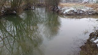
It is a left-bank tributary of the river Saale in the eastern Franconian Forest. It is a watercourse of tertiary importance. Its source lies about 650 metres (2,130 ft) above sea level from a pond northwest of the Helmbrechts quarter of Wüstenselbitz, flows around Helmbrechts at first in an easterly direction and then towards the north. As it continues it runs through the towns of Schauenstein, Selbitz and Naila, before flowing through the Höllental between Hölle and Blechschmidtenhammer cutting a channel into the dolorite rock up to 170 m (560 ft) deep.
In the village of Hölle, a district of Naila on the left bank of the Selbitz, a 262-metre-deep (860 ft) mineral spring, the Höllensprudel, has been bored. From the mouth of the Thüringische Muschwitz at the exit of the Hölle Valley and at its own confluence with the Saale near Blankenstein the Selbitz forms the border between Bavaria and Thuringia for about 2 kilometres (1.2 mi). During the Cold War division of Germany (1945–1990), the Selbitz was part of the inner German border, with fences and guard towers on the Thuringian side in the German Democratic Republic to prevent east-west traffic.
The footbridge between the Bavarian hamlet of Untereichenstein and Blankenstein is also the end of the Thuringian Rennsteig , a historical border path.
The river is 36.6 kilometres (22.7 mi) long and falls a total of 236 metres (774 ft) during its course. The name "Selbitz" probably comes from the Slavic word zelenovica and would therefore mean something like "green stream".
At almost any point the level of the Selbitz could rise theoretically without causing any problems, because it is mostly surrounded by meadows and in the town of Naila flows through a natural, but reinforced, channel between the station and the bridge by the football pitch. This enables the river to grow to more than twice its width during times of thaw, storms or heavy rain. From 2 to 4 December 2007 this could be observed. The area through which the river runs is surrounded to the left and right by strips of grassland that are used as meadows for sheep-grazing during times of the year when there is no snow.
Thuringia, officially the Free State of Thuringia, is a state of Germany. Located in central Germany, it covers 16,171 square kilometres (6,244 sq mi), being the sixth smallest of the sixteen German States. It has a population of about 2.15 million inhabitants.
The Saale, also known as the Saxon Saale and Thuringian Saale, is a river in Germany and a left-bank tributary of the Elbe. It is not to be confused with the smaller Franconian Saale, a right-bank tributary of the Main, or the Saale in Lower Saxony, a tributary of the Leine.
Hof is a Landkreis (district) in Bavaria, Germany. It is bounded by the districts of Wunsiedel, Bayreuth, Kulmbach and Kronach, the states of Thuringia and Saxony, and the Czech Republic. The city of Hof is an enclave within the district, as well as being the district's administrative seat.
Kronach is a Landkreis (district) in Bavaria, Germany. It is bounded by the districts of Hof, Kulmbach, Lichtenfels and Coburg, and the state of Thuringia.
The Rhön Mountains are a group of low mountains in central Germany, located around the border area where the states of Hesse, Bavaria and Thuringia come together. These mountains, which are at the extreme southeast end of the East Hesse Highlands, are partly a result of ancient volcanic activity. They are separated from the Vogelsberg Mountains by the river Fulda and its valley. The highest mountain in the Rhön is the Wasserkuppe which is in Hesse. The Rhön Mountains are a popular tourist destination and walking area.
Ludwigsstadt is a town in the district of Kronach, in the Upper Franconian region of Bavaria, Germany.
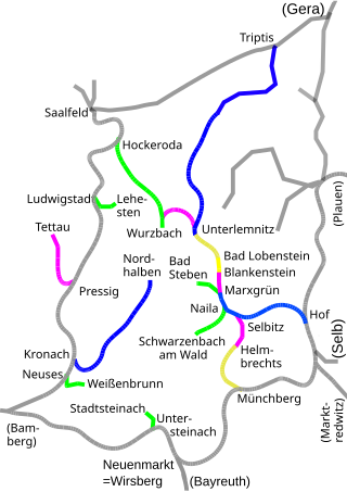
The Hof–Bad Steben railway runs from Hof through the Franconian Forest to the Bavarian state spa town Bad Steben in southern Germany. The line was opened in two stages between 1887 and 1898.
The Münchberg–Selbitz railway is a branch line in Bavaria in southern Germany. It runs from Münchberg via Helmbrechts to Selbitz. The Helmbrechts–Selbitz section has been since closed and dismantled. Passenger trains still run today between Münchberg and Helmbrechts.
The old Marxgrün station was located on the Hof–Bad Steben railway which was opened in 1887. It was the terminus on that line until 1898. From 1901 it became the junction for the railway line through the Höllen valley to Gera and, later, also Saalfeld. With the end of the Second World War the Höllen Valley railway (Höllentalbahn) losts its pan-regional significance and it was completely closed in the early 1980s. Today a halt has been built on the site of the former station which is part of the Regionalbahn from Hof to Bad Steben. The village of Marxgrün has been a district of the town of Naila since 1978.
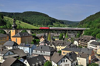
The Triptis–Marxgrün railway is a branch line in Germany that runs through the states of Thuringia and Bavaria, and which was originally built and operated by the Prussian state railways. It ran from Triptis via Ziegenrück, Bad Lobenstein and Blankenstein to Marxgrün. The only section still in service today is the stretch of line between Ebersdorf-Friesau and Blankenstein. The Thuringian section is also called the Oberlandbahn ; the Bavarian section the Höllentalbahn.
The Höllental in the Franconian Forest (Frankenwald) is a picturesque part of the Franconian region of Bavaria in southern Germany.
At 927.9 m above sea level (NN) the Dammersfeldkuppe in Bavaria is the second highest mountain after the Wasserkuppe in the Rhön, a low mountain range straddling the states of Bavaria, Hesse and Thuringia in Germany.
The Rennsteig is a ridge walk as well as an historical boundary path in the Thuringian Forest, Thuringian Highland and Franconian Forest in Central Germany. The long-distance trail runs for about 170 km from Eisenach and the Werra valley in the northwest to Blankenstein and the Selbitz river in the southeast.
The Waldnaab is the left-hand, eastern and longest headstream of the River Naab in the Upper Palatinate. At its confluence with the Haidenaab near Luhe-Wildenau, the Naab is formed. The Waldnaab is 99.1 km long; combined with the Naab, the total length is 196.6 kilometres (122.2 mi).
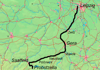
The Leipzig–Probstzella railway is a line in the German states of Saxony, Saxony-Anhalt and Thuringia. It runs from Leipzig through the valley of the White Elster via Zeitz, Gera, Triptis, the Orlasenke lowland and Saalfeld to Probstzella. Since it runs parallel with the Saal Railway but is higher, it is also called the Obere Bahn.
The Streu is a river of Thuringia and Bavaria, Germany.
The Obere Argen is a river in southwestern Bavaria and southeastern Baden-Württemberg in Germany.
Tannbach is a brook that is 8.7 kilometres (5.4 mi) long in north-east Bavaria and southern Thuringia, Germany.
Thüringische Muschwitz is a river on the border of Bavaria and Thuringia, Germany. It flows into the Selbitz near Lichtenberg.
The Rhön Cycleway is a cycle path in Germany that runs for 180 kilometres from Bad Salzungen to Hammelburg. Its route takes it through 3 states: from Thuringia via Hesse to Bavaria.
Wikimedia Commons has media related to Selbitz (Fluss) . |