Related Research Articles

Anatolia, also known as Asia Minor, is a large peninsula in Western Asia and is the western-most extension of continental Asia. The land mass of Anatolia constitutes most of the territory of contemporary Turkey. Geographically, the Anatolian region is bounded by the Turkish Straits to the north-west, the Black Sea to the north, the Armenian Highlands to the east, the Mediterranean Sea to the south, and the Aegean Sea to the west. Topographically, the Sea of Marmara connects the Black Sea with the Aegean Sea through the Bosporus strait and the Dardanelles strait, and separates Anatolia from Thrace in the Balkan peninsula of Southeastern Europe.
The Levant is the area in Southwest Asia, south of the Taurus Mountains, bounded by the Mediterranean Sea in the west, the Arabian Desert in the south, and Mesopotamia in the east. It stretches 400 mi (640 km) north to south from the Taurus Mountains to the Sinai desert, and 70–100 mi (110–160 km) east to west between the sea and the Arabian desert. The term is also sometimes used to refer to modern events or states in the region immediately bordering the eastern Mediterranean Sea: the Hatay Province of Turkey, Cyprus, Syria, Lebanon, Israel, and Jordan.

The Seleucid Empire was a Greek state in West Asia that existed during the Hellenistic period from 312 BC to 63 BC. The Seleucid Empire was founded by the Macedonian general Seleucus I Nicator, following the division of the Macedonian Empire originally founded by Alexander the Great.

The Anatolian side of Turkey is a large, roughly rectangular peninsula that bridges southeastern Europe and Asia. East Thrace, the European portion of Turkey comprises 3% of the country and 10% of its population. East Thrace is separated from Asia Minor, the Asian portion of Turkey, by the Bosporus, the Sea of Marmara and the Dardanelles. İskilip, Çorum province, is considered to be the geographical center of Earth. Turkey has the 17th longest coastline in the world with 7,200 km.
Seleucus IV Philopator, ruler of the Hellenistic Seleucid Empire, reigned from 187 BC to 175 BC over a realm consisting of Syria, Mesopotamia, Babylonia and Nearer Iran.
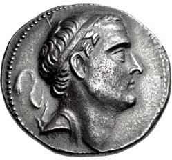
Antiochus II Theos was a Greek king of the Hellenistic Seleucid Empire who reigned from 261 to 246 BC. He succeeded his father Antiochus I Soter in the winter of 262–61 BC. He was the younger son of Antiochus I and princess Stratonice, the daughter of Demetrius Poliorcetes.

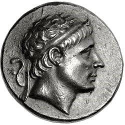
Seleucus II Callinicus Pogon, was a ruler of the Hellenistic Seleucid Empire, who reigned from 246 BC to 225 BC. Faced with multiple enemies on various fronts, and not always successful militarily, his reign was a time of great turmoil and fragmentation for the Seleucid empire, before its eventual restoration under his second son and eventual successor, Antiochus III.
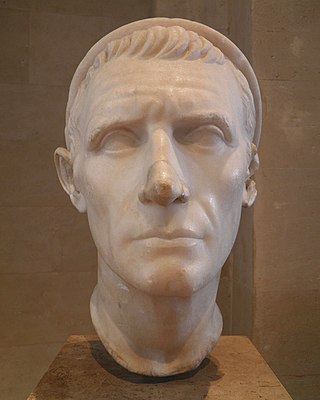
Antiochus III the Great was a Greek Hellenistic king and the 6th ruler of the Seleucid Empire, reigning from 222 to 187 BC. He ruled over the region of Syria and large parts of the rest of western Asia towards the end of the 3rd century BC. Rising to the throne at the age of eighteen in 222 BC, his early campaigns against the Ptolemaic Kingdom were unsuccessful, but in the following years Antiochus gained several military victories and substantially expanded the empire's territory. His traditional designation, the Great, reflects an epithet he assumed. He also assumed the title Basileus Megas, the traditional title of the Persian kings. A militarily active ruler, Antiochus restored much of the territory of the Seleucid Empire, before suffering a serious setback, towards the end of his reign, in his war against Rome.
Laodice I was a Greek noblewoman of Anatolia who was a close relative of the early Seleucid dynasty and was the first wife of the Seleucid Greek King Antiochus II Theos.

Upper Mesopotamia constitutes the uplands and great outwash plain of northwestern Iraq, northeastern Syria and southeastern Turkey, in the northern Middle East. Since the early Muslim conquests of the mid-7th century, the region has been known by the traditional Arabic name of al-Jazira and the Syriac variant Gāzartā or Gozarto (ܓܙܪܬܐ). The Euphrates and Tigris rivers transform Mesopotamia into almost an island, as they are joined together at the Shatt al-Arab in the Basra Governorate of Iraq, and their sources in eastern Turkey are in close proximity.

Pisidia was a region of ancient Asia Minor located north of Pamphylia, northeast of Lycia, west of Isauria and Cilicia, and south of Phrygia, corresponding roughly to the modern-day province of Antalya in Turkey. Among Pisidia's settlements were Antioch(ia) in Pisidia, Termessos, Cremna, Sagalassos, Etenna, Neapolis, Selge, Tyriacum, Laodiceia Katakekaumene and Philomelium.
The Beqaa Valley, also transliterated as Bekaa, Biqâ, and Becaa and known in classical antiquity as Coele-Syria, is a fertile valley in eastern Lebanon. It is Lebanon's most important farming region. Industry also flourishes in Beqaa, especially that related to agriculture.

The Syrian Wars were a series of six wars between the Seleucid Empire and the Ptolemaic Kingdom of Egypt, successor states to Alexander the Great's empire, during the 3rd and 2nd centuries BC over the region then called Coele-Syria, one of the few avenues into Egypt. These conflicts drained the material and manpower of both parties and led to their eventual destruction and conquest by Rome and Parthia. They are briefly mentioned in the biblical Books of the Maccabees.

The history of ancient Lebanon traces the course of events related to the geographic area in the Eastern Mediterranean of what is now known as Lebanon from the beginning of antiquity to the beginning of Arab rule.
Middle East empires have existed in the Middle East region at various periods between 3000 BCE and 1924 CE; they have been instrumental in the spreading of ideas, technology, and religions within Middle East territories and to outlying territories. Since the 7th century CE, all Middle East empires, with the exception of the Byzantine Empire, was islamic and some of them claiming the titles of Islamic caliphate. The last major empire based in the region was the Ottoman Empire.

Agriculture in Lebanon is the third most productive sector in the country after the tertiary and industrial sectors. It contributes 5 percent of GDP and 8 percent of the effective labor force. The sector includes a large informal Syrian labor and is dependent on foreign labor for its productivity. Main crops include cereals, fruits and vegetables, olives, grapes, and tobacco, along with sheep and goat herding. Mineral resources are limited and are only exploited for domestic consumption. Lebanon, which has a variety of agricultural lands, from the interior plateau of the Beqaa Valley to the narrow valleys leading downward to the sea, enables farmers to grow both European and tropical crops. Tobacco and figs are grown in the south, citrus fruits and bananas along the coast, olives in the north and around the Shouf Mountains, and fruits and vegetables in the Beqaa Valley. More exotic crops include avocados, grown near Byblos, and hashish.

The economy of Urartu refers to the principles of management of Urartu, the ancient state of Western Asia which existed from the thirteenth to the sixth century BC. It peaked around the eighth century BC but was destroyed with the fall of the state about a century later. The economy of Urartu was typical of ancient Middle East despotism and was closely associated with that of neighboring Assyria.

Phoenicia was an ancient thalassocratic civilization originating in the Levant region of the eastern Mediterranean, primarily located in modern Lebanon and coastal Syria. The territory of the Phoenicians extended and shrank throughout history, with the core of their culture stretching from Tripoli in northern Lebanon to Mount Carmel in modern Israel. Beyond their homeland, the Phoenicians extended throughout the Mediterranean, from Cyprus to the Iberian Peninsula.
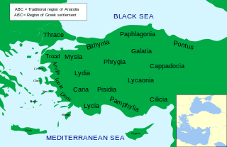
Classical Anatolia is Anatolia during Classical Antiquity. Early in that period, Anatolia was divided into several Iron Age kingdoms, most notably Lydia in the west, Phrygia in the center and Urartu in the east. Anatolia fell under Achaemenid Persian rule c. 550 BC. In the aftermath of the Greco-Persian Wars, all of Anatolia remained under Persian control except for the Aegean coast, which was incorporated in the Delian League in the 470s BC. Alexander the Great finally wrested control of the whole region from Persia in the 330s BC. After Alexander's death, his conquests were split amongst several of his trusted generals, but were under constant threat of invasion from both the Gauls and other powerful rulers in Pergamon, Pontus, and Egypt.
The ancient Sumerian economy refers to the systems of trade in ancient Mesopotamia. Sumerian city-states relied on trade due to a lack of certain materials, which had to be brought in from other regions. Their trade networks extended to places such as Oman, Arabia, Anatolia, the Indus River Valley, and the Iranian Plateau. Sumerians also bought and sold property, but land tied to the temples could not be traded. There were three types of land -- Nigenna, Kurra, and Urulal -- and only Urulal land could be traded; Nigenna land belonged to the temple, while Kurra land belonged to the people working in the temple. Within Sumer, the Sumerians could use silver, barley, or cattle as currency.
References
- 1 2 3 "Seleucid economy". Encyclopedia Iranica.
- 1 2 Howe, Timothy (2020). A Companion to Ancient Agriculture. Wiley. p. 371. ISBN 9781118970935.
- 1 2 Musti, Domenico (1984). The Cambridge Ancient History Volume 7: The Hellenistic World. Cambridge University Press. pp. 196–202.