
Bimbo is the capital of Ombella-M'poko, one of the 14 prefectures of the Central African Republic, and is located 25.5 kilometres (15.8 mi) by road southwest of the centre of the capital, Bangui. The country's second-largest city, Bimbo had a population of 124,176 as of the 2003 census and a calculated 2013 population of 267,859.
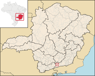
Arantina is a Brazilian municipality located in the state of Minas Gerais. Its population as of 2006 is estimated to be 3,104 people living in a total area of 89.382 km². The city belongs to the mesoregion of Sul and Sudoeste de Minas and to the microregion of Andrelândia.

Cırdaxan is a village in the Samukh Rayon of Azerbaijan.
Bəyimli is a village and municipality in the Zardab Rayon of Azerbaijan. It has a population of 830.
Gəncə is a village in the Goygol Rayon of Azerbaijan. The village forms part of the municipality of Zurnabad.

Gaj is a village in the administrative district of Gmina Rawa Mazowiecka, within Rawa County, Łódź Voivodeship, in central Poland. It lies approximately 7 kilometres (4 mi) north of Rawa Mazowiecka and 55 km (34 mi) east of the regional capital Łódź.
Wilkowisko, Limanowa is a village in the administrative district of Gmina Jodłownik, within Limanowa County, Lesser Poland Voivodeship, in southern Poland. It lies approximately 3 kilometres (2 mi) south-east of Jodłownik, 14 km (9 mi) north-west of Limanowa, and 41 km (25 mi) south-east of the regional capital Kraków.
Kogutek Kosmołowski is a village in the administrative district of Gmina Olkusz, within Olkusz County, Lesser Poland Voivodeship, in southern Poland. It lies approximately 7 kilometres (4 mi) south-east of Olkusz and 31 km (19 mi) north-west of the regional capital Kraków.
Sudół is a village in the administrative district of Gmina Jędrzejów, within Jędrzejów County, Świętokrzyskie Voivodeship, in south-central Poland. It lies approximately 5 kilometres (3 mi) north-west of Jędrzejów and 36 km (22 mi) south-west of the regional capital Kielce.

Wiśniew is a village in the administrative district of Gmina Jakubów, within Mińsk County, Masovian Voivodeship, in east-central Poland. It lies approximately 6 kilometres (4 mi) north-east of Jakubów, 14 km (9 mi) north-east of Mińsk Mazowiecki, and 50 km (31 mi) east of Warsaw city.
Zamęt is a village in the administrative district of Gmina Łagów, within Świebodzin County, Lubusz Voivodeship, in western Poland.
Przechlewko is a village in the administrative district of Gmina Przechlewo, within Człuchów County, Pomeranian Voivodeship, in northern Poland. It lies approximately 6 kilometres (4 mi) north of Przechlewo, 24 km (15 mi) north of Człuchów, and 107 km (66 mi) south-west of the regional capital Gdańsk.
Stąpławki is a village in the administrative district of Gmina Reszel, within Kętrzyn County, Warmian-Masurian Voivodeship, in northern Poland. It lies approximately 9 kilometres (6 mi) south-east of Reszel, 12 km (7 mi) south-west of Kętrzyn, and 56 km (35 mi) north-east of the regional capital Olsztyn.
Dołgie is a village in the administrative district of Gmina Biały Bór, within Szczecinek County, West Pomeranian Voivodeship, in north-western Poland. It lies approximately 13 kilometres (8 mi) south of Biały Bór, 12 km (7 mi) north-east of Szczecinek, and 153 km (95 mi) east of the regional capital Szczecin.
Chrášťany is a village and municipality in Prague-West District in the Central Bohemian Region of the Czech Republic.
Senador Alexandre Costa is a municipality in the state of Maranhão in the Northeast region of Brazil.
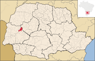
Nova Aurora, Paraná is a municipality in the state of Paraná in the Southern Region of Brazil.
Veliko Bonjince is a village in the municipality of Babušnica, Serbia. According to the 2002 census, the village has a population of 459 people.

Buzekara is a village in the municipality of Brčko, Bosnia and Herzegovina.
Grapska Donja is a village in the municipality of Doboj, Bosnia and Herzegovina.


