Related Research Articles

New York State Route 5 (NY 5) is a state highway that extends for 370.80 miles (596.74 km) across the state of New York in the United States. It begins at the Pennsylvania state line in the Chautauqua County town of Ripley and passes through Buffalo, Syracuse, Utica, Schenectady, and several other smaller cities and communities on its way to downtown Albany in Albany County, where it terminates at U.S. Route 9 (US 9), here routed along the service roads for Interstate 787 (I-787). Prior to the construction of the New York State Thruway, it was one of two main east–west highways traversing upstate New York, the other being US 20. West of New York, the road continues as Pennsylvania Route 5 (PA 5) to Erie.
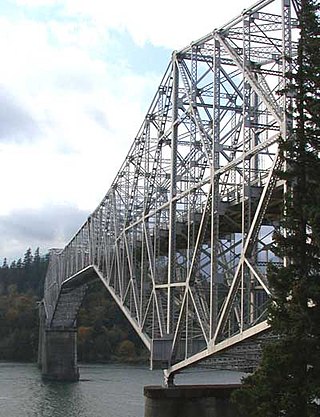
The Bridge of the Gods is a steel truss cantilever bridge that spans the Columbia River between Cascade Locks, Oregon, and Washington state near North Bonneville. It is approximately 40 miles (64 km) east of Portland, Oregon, and 4 miles (6.4 km) upriver from Bonneville Dam. It is a toll bridge operated by the Port of Cascade Locks.
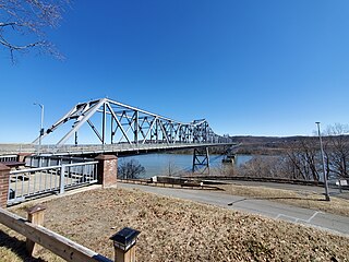
The Rip Van Winkle Bridge is a 5,040 ft (1,540 m) cantilever bridge spanning the Hudson River between Hudson, New York and Catskill, New York. Affording 145 feet (44 m) of clearance over the water, the structure carries NY 23 across the river, connecting US 9W and NY 385 on the west side with NY 9G on the east side. The bridge also passes over Rogers Island and Hallenbeck Creek.

Sideling Hill Tunnel is one of three original Pennsylvania Turnpike tunnels abandoned after two massive realignment projects. The others are nearby Rays Hill Tunnel, and farther west, the Laurel Hill Tunnel. It was less expensive to realign the Turnpike than to bore a second tube for four lane traffic. Sideling Hill Tunnel is 6,782 feet (2,067 m) long.

Rays Hill Tunnel is one of three original Pennsylvania Turnpike tunnels that were abandoned after two massive realignment projects. The others included the Sideling Hill Tunnel, and farther west, the Laurel Hill Tunnel.

New York State Route 278 (NY 278) is a state highway in Rensselaer County, New York, in the United States. The route, 1.51 miles (2.43 km) in length, is located in a rural section of the town of Brunswick. It climbs uphill from a southern terminus at NY 2 in the hamlet of Clums Corners to its northern end at NY 7. The road was taken over by the state of New York in 1905 and designated NY 278 c. 1938.

New York State Route 377 (NY 377) is a north–south state highway located within Albany County, New York, in the United States. The four-lane route extends for 1.76 miles (2.83 km) through mostly residential areas from an interchange with U.S. Route 9 (US 9) in the city of Albany to an intersection with NY 378 in the village of Menands. NY 377 was assigned to its current alignment in the mid-1930s.
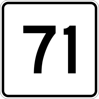
Massachusetts Route 71 and New York State Route 71 (NY 71) are adjoining state highways in the states of Massachusetts and New York in the United States. The two highways form a continuous roadway connecting NY 22 in Hillsdale, Columbia County, New York, to Route 23 and Route 41 in Great Barrington, Berkshire County, Massachusetts. Combined, Route 71 and NY 71 extend for 7.93 miles (12.76 km) as a two-lane road through mostly rural areas in the Taconic Mountains, serving only small, unincorporated communities in both states. Both routes are part of the Henry Knox Trail.
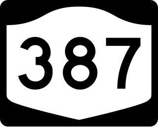
New York State Route 387 (NY 387) is a 2.95-mile (4.75 km) state highway located within the town of Murray in Orleans County, New York, in the United States. It serves as a north–south connector between NY 31 in the hamlet of Fancher and NY 104 midway between the hamlets of East Gaines and Murray. In between, NY 387 crosses the Erie Canal and passes through the community of Brockville. The route was assigned to its current alignment as part of the 1930 renumbering of state highways in New York.
New York State Route 139 (NY 139) is a 2.81-mile (4.52 km) state highway located within the town of Somers in Westchester County, New York, in the United States. It connects the hamlet of Whitehall Corners at an intersection with NY 100 with the hamlet of Lincolndale at a junction with U.S. Route 202 (US 202). The entirety of NY 139, known as Primrose Street, was assigned in the early 1930s.

New York State Route 133 (NY 133) is an 8.71-mile (14.02 km) long state highway in Westchester County, New York, in the United States. It begins at U.S. Route 9 (US 9) in the village of Ossining, goes through several hamlets in the town of New Castle, and ends at NY 117 in the village of Mount Kisco.

New York State Route 261 (NY 261) is a north–south state highway located west of the city of Rochester in Monroe County, New York, in the United States. It extends for 7.70 miles (12.39 km) through mostly rural areas from an intersection with NY 104 on the Greece–Parma town line to a dead end at the Lake Ontario shoreline in Greece. The majority of NY 261 is situated on the boundary between the towns of Greece and Parma; however, the last 2 miles (3.2 km) of the route are located solely in Greece. NY 261 meets the Lake Ontario State Parkway southwest of Manitou Beach on the latter stretch.

New York State Route 175 is an east–west state highway located entirely within Onondaga County, New York, in the United States. The 15.46-mile (24.88 km) route begins at an intersection with U.S. Route 20 (US 20) east of the village of Skaneateles and passes through the village of Marcellus before ending at a junction with US 11 in Syracuse. The highway was designated in the 1930 renumbering of state highways in New York.

New York State Route 108 (NY 108) is a 1.72-mile-long (2.77 km) north–south state highway located on the Suffolk County side of the Suffolk–Nassau county line on Long Island, New York, in the United States. It is a spur route connecting NY 25A in Cold Spring Harbor to the Cold Spring Harbor station on the Long Island Rail Road's Port Jefferson Branch via Harbor Road. Harbor Road terminates at an intersection with Woodbury Road, on the Nassau County line, which carries County Route 11 to the east and unsigned County Route 12 to the west. NY 108, assigned in the early 1930s, is the shortest state highway on Long Island.

New York State Route 336 (NY 336) is an east–west state highway located within Seneca County in the Finger Lakes region of New York in the United States. It extends for 4.64 miles (7.47 km), mostly along the Fayette–Varick town line, from an intersection with NY 96A in the town of Fayette to a junction with NY 414 south of the hamlet of Fayette on the Fayette–Varick border. The section of NY 336 that runs along the town line is known as Townline Road. NY 336 was assigned to its current alignment in the early 1930s.
New York State Route 349 (NY 349) is an east–west state highway in Fulton County, New York, in the United States. The highway extends for 3.58 miles (5.76 km) across largely rural terrain from an intersection with NY 30A in the town of Johnstown to a junction with NY 30 in the town of Mayfield. The westernmost section of the route is known as East State Street Extension. NY 349 was assigned c. 1931 to the portion of its alignment between County Route 154 and NY 30. It was extended west to its present terminus in the mid-1950s after NY 148 was rerouted onto an arterial highway between Gloversville and Mayfield.
New York State Route 395 (NY 395) is a state highway located within the town of Duanesburg in Schenectady County, New York, in the United States. It connects NY 7 to U.S. Route 20 (US 20) by way of the village of Delanson. The route was assigned as part of the 1930 renumbering of state highways in New York and has not been altered since.

New York State Route 373 (NY 373) is a short state highway in Essex County, New York, within Adirondack Park. It begins at U.S. Route 9 (US 9) and proceeds eastward, ending at a ferry landing on Lake Champlain. It intersects two county routes, several local roads, and a reference route—NY 912T—which connects it with US 9. NY 373 is the only connector between US 9 and the hamlet of Port Kent and the ferry that serves it.
The Port Kent and Hopkinton Turnpike was a 19th-century toll road in the North Country of New York in the United States. It began in the town of Hopkinton and ended at the hamlet of Port Kent, located on the western shore of Lake Champlain. The turnpike was constructed in the early 1830s and was completed in 1833. The tolls along the road were removed just five years later; however, parts of the former turnpike later became the basis for several 20th century state highways. One, the former New York State Route 99 (NY 99), is still known today as the "Port Kent–Hopkinton Turnpike".

The Cheshire Bridge spans the Connecticut River between Charlestown, New Hampshire and Springfield, Vermont.
References
- 1 2 Hulbert, Archer Butler (1971). Historic Highways of America. Ams Pr Inc.
- ↑ Baer, Christopher T. (2005). "Turnpikes". In Eisenstadt, Peter R.; Moss, Laura-Eve (eds.). The Encyclopedia of New York State. Syracuse University Press. pp. 1588–1589. ISBN 978-0-8156-0808-0.
- ↑ 1634–1699: McCusker, J. J. (1997). How Much Is That in Real Money? A Historical Price Index for Use as a Deflator of Money Values in the Economy of the United States: Addenda et Corrigenda (PDF). American Antiquarian Society. 1700–1799: McCusker, J. J. (1992). How Much Is That in Real Money? A Historical Price Index for Use as a Deflator of Money Values in the Economy of the United States (PDF). American Antiquarian Society. 1800–present: Federal Reserve Bank of Minneapolis. "Consumer Price Index (estimate) 1800–" . Retrieved February 29, 2024.
- ↑ "Seneca Turnpike - Clinton Historical Society". clintonhistory.org.