
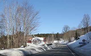
Birkeland is the administrative centre of the municipality of Birkenes in Aust-Agder county, Norway. The village is located on the eastern shore of the river Tovdalselva, across the river from the village of Flakk. The Norwegian National Road 41 runs through the village. The village is located about 30 kilometres (19 mi) northeast of the city of Kristiansand and about 14 kilometres (8.7 mi) northwest of Lillesand.

Ogge is a lake in the municipalities of Birkenes and Iveland in Aust-Agder county, Norway. It is located about 40 kilometres (25 mi) north of the city of Kristiansand, just east of the villages of Vatnestrøm and Oggevatn. The 6.71-square-kilometre (2.59 sq mi) lake includes about 360 islands and reefs. The overall length of the lake is approximately 16 kilometres (9.9 mi). The Sørlandsbanen railway line and the Norwegian County Road 405 both run along the west side of the lake.
Hartevatnet or Hartevatn is a lake in the municipality of Bykle in Aust-Agder county, Norway. It is located along the river Otra, on the south side of the village of Hovden. The lake is a good fishing spot and it contains lots of brown trout. The Norwegian National Road 9 runs along the eastern shore of the lake. The lake Skyvatn lies about 6 kilometres (3.7 mi) to the northwest and the lake Holmavatnet lies about 13 kilometres (8.1 mi) to the northwest.
Herefossfjorden is a lake in the municipality of Birkenes in Aust-Agder county, Norway. The 3.7-square-kilometre (1.4 sq mi) lake is about 9 kilometres (5.6 mi) long and it is part of the Tovdalselva river. The Gauslåfjorden and Uldalsåna lakes flow into Herefossfjorden near the village of Herefoss at the northern end of the lake. The Uldalsåna lake is held back by a dam and the Gauslåfjorden flows over a waterfall into the Herefossfjorden. The Norwegian National Road 41 runs along the eastern shore. The village of Herefoss lies on the northern edge of the lake and the village of Søre Herefoss lies at the southern end of the fjord. The old municipality of Herefoss existed from 1838 until 1967 and it included all the land surrounding the lake.
Holmavatnet is a lake the Setesdalsheiene mountains of Southern Norway. It is located on the border of the municipalities of Suldal, Vinje, and a small part in Bykle. The southeastern corner of the lake is in Bykle, and it is the northernmost part of all of Aust-Agder county. The lake Skyvatn is located about 5 kilometres (3.1 mi) to the south of the lake.

Herefoss is a village in Birkenes municipality in Aust-Agder county, Norway. The village is located on the northeastern end of the Herefossfjorden which is a large lake on the river Tovdalselva. The Norwegian National Road 41 runs through the village connecting it to Søre Herefoss, about 8 kilometres (5.0 mi) to the south, and to Hynnekleiv in Froland, about 10 kilometres (6.2 mi) to the north. The lake Uldalsåna lies about 2 kilometres (1.2 mi) to the northwest.

Norwegian County Road 406 is a Norwegian county road in Birkenes municipality in Aust-Agder county, Norway. The 18.1-kilometre (11.2 mi) long road runs between the village of Sennumstad on the Tovdalselva river to the village of Stemlona. The road connects to the Norwegian County Road 405 at Stemlona and it connects to the Norwegian National Road 41 at its other end at Sennumstad. The road runs through a fairly rural area in Birkenes. The Sørlandsbanen railway line crosses over the road at Fidje.
Håbbesland is a village in Birkenes municipality in Aust-Agder county, Norway. The village is located about 5 kilometres (3.1 mi) to the northeast of the municipal centre of Birkeland.
Mollestad is a village in Birkenes municipality in Aust-Agder county, Norway. The village is located on both sides of the river Tovdalselva, just south of the municipal centre of Birkeland. The Birkenes Church is located in eastern Mollestad (Østre Mollestad). The Norwegian National Road 41 runs through the village. The village of Rugsland lies to the south, Svaland lies to the west, and Tveide lies to the east.
Oggevatn is a village in Birkenes municipality in Aust-Agder county, Norway. The village is located on the western shore of the large lake Ogge, just north of the municipal border with Iveland. The Sørlandsbanen railway line runs through the village. The village of Vatnestrøm lies about 5 kilometres (3.1 mi) southwest of Oggevatn.
Rugsland is a village in Birkenes municipality in Aust-Agder county, Norway. The village is located on the western shore of the river Tovdalselva, about 5 kilometres (3.1 mi) south of the village of Mollestad. The village of Svaland lies about 5 kilometres (3.1 mi) to the northwest.
Søre Herefoss is a village in Birkenes municipality in Aust-Agder county, Norway. The village is located on the southeastern shore of the lake Herefossfjorden, at the junction of the Norwegian National Road 41 and the Norwegian County Road 404. The village of Herefoss lies about 7 kilometres (4.3 mi) to the north, the village of Sennumstad lies about 5.5 kilometres (3.4 mi) to the south, and the town of Grimstad lies about 30 kilometres (19 mi) to the southeast.
Tveide is a village in Birkenes municipality in Aust-Agder county, Norway. The village is located about 3 kilometres (1.9 mi) south of the municipal centre of Birkeland. Historically, there was a railway station here along the now-closed Lillesand-Flaksvand Line.
Vatnestrøm is a village in Iveland municipality in Aust-Agder county, Norway. The village is located along the Norwegian County Road 405, on the western shore of the lake Ogge. The municipal centre of Birketveit lies about 12 kilometres (7.5 mi) to the northwest and the village of Oggevatn in the neighboring municipality of Birkenes lies about 6 kilometres (3.7 mi) to the northeast.
Væting is a village in Birkenes municipality in Aust-Agder county, Norway. The village is located just off the Norwegian County Road 406, about 5 kilometres (3.1 mi) northwest of the village of Senumstad.
Ås is a village in Birkenes municipality in Aust-Agder county, Norway. The village is located about 2 kilometres (1.2 mi) southeast of the village of Engesland, along the Norwegian County Road 405.

Norwegian National Road 41 is a Norwegian national road that runs through Telemark, Aust-Agder, and Vest-Agder counties in Norway. The road runs between the village of Brunkeberg in Kviteseid municipality in Telemark county in the north and Timenes in Hånes in the city of Kristiansand in Vest-Agder county in the south. The 172.9-kilometre (107.4 mi) long road connects to the European route E134 highway in the north and to the European route E18 highway in the south. The road runs for 12.5 kilometres (7.8 mi) in Vest-Agder county, 89 kilometres (55 mi) in Aust-Agder county, and 71.4 kilometres (44.4 mi) in Telemark county. The southern half of the road runs along the river Tovdalselva and the lake Herefossfjorden, and it is located in a fault zone called the Kristiansand-Porsgrunn grabenen.
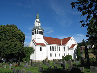
Birkenes Church is a parish church in Birkenes municipality in Aust-Agder county, Norway. It is located in the village of Mollestad, about 3.5 kilometres (2.2 mi) southwest of the municipal centre of Birkeland. The church is part of the Birkenes parish in the Vest-Nedenes deanery in the Diocese of Agder og Telemark. The white, wooden church was built in a cruciform style in 1858 by the architect Christian Heinrich Grosch. It was constructed on the same site as the previous church. The present church seats about 650 people. It was consecrated on 1 December 1858 by the Bishop Jacob von der Lippe.

Mykland is a former municipality in Aust-Agder county, Norway. The 306-square-kilometre (118 sq mi) municipality existed from 1876 until 1967 when it was merged into the neighboring municipality of Froland. Mykland included the inland areas between the rivers Tovdalsåna and the Rettåna. The administrative centre was the village of Mykland where the Mykland Church is located.


