Serengeti District

Last updated
Serengeti District
Wilaya ya Serengeti
Serengeti District in Mara 2022.svg
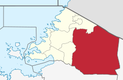
Serengeti District of Mara Region
Coordinates: 01°50′S034°40′E / 1.833°S 34.667°E / -1.833; 34.667
CountryFlag of Tanzania.svg  Tanzania
Region Mara Region
Area
  Total
11,156 km2 (4,307 sq mi)
Population
 (2022)
  Total
340,349
  Density31/km2 (79/sq mi)
Website http://serengetidc.go.tz/

Serengeti District is one of the seven districts of Mara Region of Tanzania. Its administrative centre is the town of Mugumu. It is home to part of the world-famous Serengeti National Park a UNESCO World Heritage Site and contains one of the western gates to the park. [1]

Contents

According to the 2022 Tanzania National Census, the population of Serengeti District was 340,349. [2] [3]

Transport

There are no paved roads connecting Serengeti District with the rest of the country. The unpaved trunk road T17 from Musoma to Arusha passes through the district from west to east. [4]

Administrative subdivisions

As of 2012, Serengeti District was administratively divided into 28 wards. [2]

Wards

  • Busawe
  • Geitasamo
  • Ikoma
  • Issenye
  • Kebanchabancha
  • Kenyamonta
  • Kisaka
  • Kisangura
  • Kyambahi
  • Machochwe
  • Magange
  • Majimoto
  • Manchira
  • Mbalibali
  • Morotonga
  • Mosongo
  • Mugumu
  • Natta
  • Nyamatare
  • Nyambureti
  • Nyamoko
  • Nyansurura
  • Rigicha
  • Ring'wani
  • Rung'abure
  • Sedeco
  • Stendi Kuu
  • Uwanja wa Ndege

References

  1. "Serengeti National Park". Serengeti National Park. Retrieved 11 January 2016.
  2. 1 2 "Census 2012". National Bureau of Statistics. Archived from the original on 5 March 2016. Retrieved 9 December 2015.
  3. "Mara (Region, Tanzania) - Population Statistics, Charts, Map and Location". www.citypopulation.de. Retrieved 2024-02-09.
  4. "Trunk and Regional Roads in Tanzania". Tanroads. Archived from the original on November 22, 2012. Retrieved 1 December 2015.