
Nuuk Airport (Greenlandic: Mittarfik Nuuk; Danish: Godthåb Lufthavn; is an airport serving Nuuk, the capital of Greenland. The airport is a technical base and focus city for Air Greenland, the flag carrier airline of Greenland, linking the capital with several towns in western and south-western part of the country, including the airline hub at Kangerlussuaq Airport. With connections to Iceland, Nuuk Airport is also one of six international airports in Greenland but serves only destinations within Greenland and Iceland. International connections are made with flights to either Keflavík International Airport in Iceland or Kangerlussuaq Airport.

Maniitsoq, formerly Sukkertoppen, is a town in Maniitsoq Island, western Greenland located in the Qeqqata municipality. With 2,534 inhabitants as of 2020, it is the sixth-largest town in Greenland.

Sisimiut, formerly known by its colonial name Holsteinsborg, is the capital and largest city of the Qeqqata municipality, the second-largest city in Greenland, and the largest arctic city in North America. It is located in central-western Greenland, on the coast of Davis Strait, approximately 320 km (200 mi) north of Nuuk.
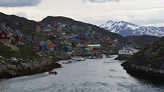
Kangaamiut, formerly known as Gammel Sukkertoppen, is a settlement with a population of 293 (2020) in the Qeqqata municipality in central-western Greenland.
Sarfannguit is a settlement in the Qeqqata municipality in central-western Greenland. Its population was 96 in 2020. The settlement was founded in 1843.

Oqaatsut, formerly Rodebay or Rodebaai, is a settlement in the Qaasuitsup municipality, in western Greenland. It had 29 inhabitants in 2020. The modern name of the settlement is Kalaallisut for "Cormorants". The village is served by the communal all-purpose Pisiffik store.

TELE Greenland A/S or TELE Greenland Group is a Greenlandic telecommunications company dating back to 1879. TELE Greenland is the largest telecommunications company in Greenland. The company's headquarters are located in Nuuk.

Maniitsoq Airport is an airport located on Maniitsoq Island, 0.5 NM northwest of Maniitsoq, a town in the Qeqqata municipality in central-western Greenland. It can serve STOL aircraft, although there is no deicing equipment at the airport, which is costly and problematic in Greenlandic winter.
Upernavik Archipelago is a vast coastal archipelago in the Avannaata municipality in northwestern Greenland, off the shores of northeastern Baffin Bay. The archipelago extends from the northwestern coast of Sigguup Nunaa peninsula in the south at approximately 71°50′N56°00′W to the southern end of Melville Bay in the north at approximately 74°50′N57°30′W.

Kangerlussuaq Fjord is a long fjord in the Qeqqata municipality in central-western Greenland. The fjord is 190 km (120 mi) long and between 1.5 km (0.93 mi) and 8 km (5.0 mi) wide, flowing from the estuary of Qinnguata Kuussua river to the southwest, and emptying into the Davis Strait. It is the longest fjord of western Greenland.
Nuup Kangerlua is a 160 km (99.4 mi) long fjord in the Sermersooq municipality in southwestern Greenland. It was formerly known by its colonial name as Godthaab Fjord, Gilbert Sound and Baal's River.
Kangerlussuatsiaq Fjord is a fjord in the Qeqqata municipality in western Greenland. Taking its source in the tidewater glaciers draining the Maniitsoq ice cap, the fjord flows in a deep canyon through a mountainous, uninhabited region, emptying into Davis Strait near the settlement of Kangaamiut.
Kangaamiut Kangerluarsuat Fjord is a fjord in the Qeqqata municipality in western Greenland. The fjord is located halfway between the lower runs of the long Kangerlussuaq Fjord in the north, and Kangerlussuatsiaq Fjord in the south, emptying into Davis Strait.
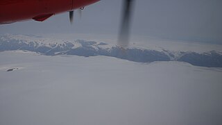
Maniitsoq Ice Cap is a 58 km × 41 km ice cap in the Qeqqata municipality in western Greenland.

Majorqaq is a meltwater river and valley of the same name in the Qeqqata municipality in central-western Greenland. It is one of the widest rivers in western Greenland, draining the Greenland ice sheet.
Isortoq Fjord is a fjord in the Qeqqata municipality in western Greenland. The fjord to the east of Maniitsoq, emptying into Davis Strait. Majorqaq, one of the widest rivers in western Greenland draining the Greenland ice sheet, empties into the fjord head.
Tasiusaq Bay is a bay in the Upernavik Archipelago in the Qaasuitsup municipality in northwestern Greenland. It is an indentation of northeastern Baffin Bay. The name of the bay derives from the name of the settlement of the same name in the bay.
Upernavik Icefjord is a fjord in the Qaasuitsup municipality in northwestern Greenland.

