History
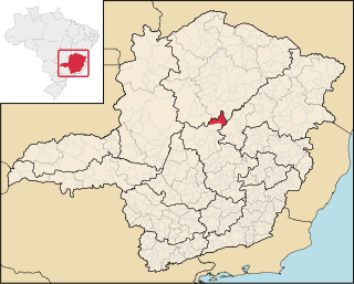
The Serra Nova State Park was created by state governor decree on 21 October 2003 in the municipality of Rio Pardo de Minas, with an area of 12,658.29 hectares (31,279.3 acres). In 2008 IEF held public consultations on expanding the park to include the Serra do Talhado, and renaming the park to the Serra Nova and Talhado State Park. The expanded unit would cover about 50,000 hectares (120,000 acres). Work on the management plan for the expanded park was scheduled to start in 2010. This would include a survey of flora and fauna, defining infrastructure needs including a guard house, administrative headquarters, restrooms and so on. The park could then be opened to the public.
Environment
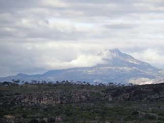
The climate is tropical, with average annual temperature of 28 °C (82 °F). The park protects part of the Espinhaço Complex ecosystem, which is threatened by agriculture. The park's vegetation is mainly rupestrian fields, with some native trees such as Jataipeba, Aroeira and Sucupira. There are some areas of closed forest. Vegetation includes cerrado, rocky meadows and dry forest.
Fauna include cougar (Puma concolor), crab-eating fox (Cerdocyon thous), maned wolf (Chrysocyon brachyurus), ferrets, tufted capuchin (Sapajus apella), southern tamandua (Tamandua tetradactyla), helmeted manakin (Antilophia galeata), hummingbirds, salamanders and snakes such as boa constrictor (Boa constrictor), rattlesnakes, coral snake (Micrurus lemniscatus) and Bothrops jararacussu . In 2007 researchers from the PUC Minas observed 27 species of amphibians, including one that is probably new to science.
Visiting
As of 2017 the park was open to visitors from 8:00 to 17:00 daily. Attractions include the Cachoeira do Serrado, Poço do Jacaré, Escorregador and Poço da Sereia waterfalls and pools. Prohibited activities included making sound recordings, practicing extreme sports such as abseiling, ziplining or climbing, bringing domestic animals, using chemical products for bathing or washing, hunting and fishing, collecting rocks, plants or animals, making fires and camping inside the park. Visitors are advised to stick to well marked trails, preferably in the company of a local guide, and to stay away from watercourses at the first sign of rain.

Nova Lima is a municipality of about 87,000 people, whose downtown is located about 20 kilometers south of Belo Horizonte, the capital of the south-eastern Brazilian state of Minas Gerais. Mining is one of the main economical activities of the city, including the extraction of Iron Ore and Gold. The most famous mine in the city is Morro Velho, a gold mine of 2,700 metres (8,900 ft) depth.

Buenópolis is a Brazilian municipality located in the northeast of the state of Minas Gerais. Its population as of 2020 was 10,353 living in a total area of 1,610 km2. The city belongs to the statistical mesoregion of Central Mineira and to the statistical microregion of Curvelo. It became a municipality in 1938.

Joaquim Felício is a municipality located in the northeast of the state of Minas Gerais. Its population as of 2020 was 4,727 living in a total area of 791 km2. The city belongs to the statistical mesoregion of Central Mineira and to the statistical microregion of Curvelo. It became a municipality in 1962.

Serra Azul de Minas is a Brazilian municipality located in the state of Minas Gerais. The city belongs to the mesoregion Metropolitana de Belo Horizonte and to the microregion of Conceição do Mato Dentro. As of 2020, the estimated population was 4,292.

Rio Pardo de Minas is a municipality in the northeast of the Brazilian state of Minas Gerais. Its population in 2020 was 31,045 inhabitants in a total area of 3,117 square kilometres (1,203 sq mi).
The Mosquito River is a river of Minas Gerais state in southeastern Brazil. It is a tributary of the Gorutuba River.

Lambari is a municipality in the state of Minas Gerais in the Southeast region of Brazil.

Marliéria is a municipality in the state of Minas Gerais in the Southeast region of Brazil.
Mata dos Ausentes Ecological Station is a state-administered ecological station in Minas Gerais, Brazil.
The Serra de Santa Bárbara State Park is a state park in the state of Mato Grosso, Brazil. It preserves a unique environment where the Amazon rainforest, pantanal and cerrado meet, and holds many endemic or endangered species.

The Biribiri State Park is a state park in the state of Minas Gerais, Brazil. It protects a mountainous region of cerrado. The park contains an abandoned village, once home to workers in a textile factory, which is now a tourist attraction.

The Nova Baden State Park is a state park in the state of Minas Gerais, Brazil. It protects a rugged, forested area that is home to several rare or endangered species of mammals.

The Pico do Itambé State Park is a state park in the state of Minas Gerais, Brazil. It protects one of the higher peaks in the state.

The Serra do Cabral State Park is a state park in the state of Minas Gerais, Brazil.

The Serra do Rola-Moça State Park is a state park in the state of Minas Gerais, Brazil. It protects a rugged area in the transition zone between cerrado and Atlantic Forest. Springs in the park are important to the water supply of the state capital, Belo Horizonte.

The Grão Mogol State Park is a state park in the state of Minas Gerais, Brazil. It protects an area of high, mountainous terrain with cerrado vegetation, important as a source of water in a region with a dry climate.

The Caminho dos Gerais State Park Portuguese: Parque Estadual Caminho dos Gerais is a state park in the state of Minas Gerais, Brazil. It protects a mountainous area with cerrado and caatinga vegetation that is an important source of water in a dry region.

The Serra Negra State Park Portuguese: Parque Estadual da Serra Negra is a state park in the state of Minas Gerais, Brazil. It protects a mountainous area in the Atlantic Forest biome, an important source of water in a dry region, and a potential source of tourism revenue in an area with many social problems.

The Rio Preto State Park is a state park in the state of Minas Gerais, Brazil. It protects a mountainous area of cerrado vegetation that is home to various endemic, rare or endangered species. Trails provide environmental interpretation, and lead to lookouts that give panoramic views, to rivers and waterfalls, and to archaeological sites with rock paintings.

The Rio Doce State Park is a state park in the state of Minas Gerais, Brazil. It protects a large remnant of Atlantic Forest, and includes a system of lagoons rich in species of native fish.


