Serrata | |
---|---|
Comune | |
Comune di Serrata | |
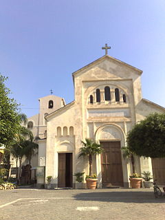
Parrocchia di San Pantaleone | |
Coordinates: 38°32′N16°5′E / 38.533°N 16.083°E Coordinates: 38°32′N16°5′E / 38.533°N 16.083°E | |
Country | Italy |
Region | Calabria |
Metropolitan city | Reggio Calabria (RC) |
Government | |
• Mayor | Salvatore Vinci |
Area | |
• Total | 21.8 km2 (8.4 sq mi) |
Population (Dec. 2004) | |
• Total | 922 |
• Density | 42/km2 (110/sq mi) |
Demonym(s) | Serratesi |
Time zone | CET (UTC+1) |
• Summer (DST) | CEST (UTC+2) |
Postal code | 89020 |
Dialing code | 0966 |
Serrata is a comune (municipality) in the Province of Reggio Calabria in the Italian region Calabria, located about 60 kilometres (37 mi) southwest of Catanzaro and about 60 km northeast of Reggio Calabria. As of 31 December 2004, it had a population of 922 and an area of 21.8 square kilometres (8.4 sq mi). [1]
The comune is a basic administrative division in Italy, roughly equivalent to a township or municipality.
The Province of Reggio Calabria is a province in the Calabria region of Italy. It is the southernmost province in mainland Italy and is separated from the island of Sicily by the Strait of Messina. The Aspromonte massif dominates the western part, and with its long coastline, the province is a popular tourist destination during the summer. The capital is the city of Reggio.
Italy, officially the Italian Republic, is a country in Europe. Located in the middle of the Mediterranean Sea, Italy shares open land borders with France, Switzerland, Austria, Slovenia and the enclaved microstates San Marino and Vatican City. Italy covers an area of 301,340 km2 (116,350 sq mi) and has a largely temperate seasonal and Mediterranean climate. With around 61 million inhabitants, it is the fourth-most populous EU member state and the most populous country in Southern Europe.
Serrata borders the following municipalities: Candidoni, Dinami, Laureana di Borrello, Mileto, San Pietro di Caridà.
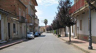
Candidoni is a comune (municipality) in the Metropolitan City of Reggio Calabria in the Italian region Calabria, located about 60 kilometres (37 mi) southwest of Catanzaro and about 60 kilometres (37 mi) northeast of Reggio Calabria.
Dinami is a comune (municipality) in the Province of Vibo Valentia in the Italian region Calabria, located about 90 kilometres (56 mi) southwest of Catanzaro and about 32 kilometres (20 mi) southeast of Vibo Valentia. As of 31 December 2004, it had a population of 3,258 and an area of 44.1 square kilometres (17.0 sq mi).
Laureana di Borrello is a comune (municipality) in the Metropolitan City of Reggio Calabria in the Italian region of Calabria, located about 60 kilometres (37 mi) southwest of Catanzaro and about 60 kilometres (37 mi) northeast of Reggio Calabria.
Bivongi is a comune (municipality) in the Province of Reggio Calabria in the Italian region Calabria, located about 50 kilometres (31 mi) southwest of Catanzaro and about 80 kilometres (50 mi) northeast of Reggio Calabria in the Stilaro Valley, at the feet of the Monte Consolino.
Cittanova is a comune (municipality) in the Metropolitan City of Reggio Calabria in the Italian region Calabria, located about 80 kilometres (50 mi) southwest of Catanzaro and about 45 kilometres (28 mi) northeast of Reggio Calabria.
Cosoleto is a comune (municipality) in the Province of Reggio Calabria in the Italian region Calabria, located about 90 kilometres (56 mi) southwest of Catanzaro and about 30 kilometres (19 mi) northeast of Reggio Calabria. As of 31 December 2004, it had a population of 1,006 and an area of 33.8 square kilometres (13.1 sq mi).
Feroleto della Chiesa is a comune (municipality) in the Province of Reggio Calabria in the Italian region Calabria, located about 70 kilometres (43 mi) southwest of Catanzaro and about 50 kilometres (31 mi) northeast of Reggio Calabria. As of 31 December 2004, it had a population of 1,849 and an area of 7.6 square kilometres (2.9 sq mi).
Giffone is a comune (municipality) in the Province of Reggio Calabria in the Italian region Calabria, located about 60 kilometres (37 mi) southwest of Catanzaro and about 60 kilometres (37 mi) northeast of Reggio Calabria. As of 31 December 2004, it had a population of 2,154 and an area of 14.5 square kilometres (5.6 sq mi).
Grotteria is a comune (municipality) in the Province of Reggio Calabria in the Italian region Calabria, located about 70 kilometres (43 mi) southwest of Catanzaro and about 60 kilometres (37 mi) northeast of Reggio Calabria.
Marina di Gioiosa Ionica is a comune (municipality) in the Province of Reggio Calabria in the Italian region Calabria, located about 80 kilometres (50 mi) southwest of Catanzaro and about 120 kilometres (75 mi) northeast of Reggio Calabria. As of 30 September 2017, it had a population of 6,615 and an area of 15.9 square kilometres (6.1 sq mi).
Melito di Porto Salvo is a comune (municipality) in the Metropolitan City of Reggio Calabria in the Italian region Calabria, located about 130 kilometres (81 mi) southwest of Catanzaro and about 25 kilometres (16 mi) southeast of Reggio Calabria; and is also the southernmost municipality on the Italian Peninsula. It is part of the Bovesia Greek-speaking area of Calabria, occupying a hilly area which descends towards the Ionian Sea.
Montebello Ionico is a comune (municipality) in the Province of Reggio Calabria in the Italian region Calabria, located about 130 kilometres (81 mi) southwest of Catanzaro and about 15 kilometres (9 mi) southeast of Reggio Calabria.
Motta San Giovanni is a comune (municipality) in the Province of Reggio Calabria in the Italian region Calabria, located about 130 kilometres (81 mi) southwest of Catanzaro and about 13 kilometres (8 mi) southeast of Reggio Calabria.
Placanica is a comune in the Province of Reggio Calabria in the Italian region Calabria, located about 60 kilometres (37 mi) south of Catanzaro and about 80 kilometres (50 mi) northeast of Reggio Calabria. Placanica borders the following communes: Caulonia, Pazzano, Stignano.
Roghudi is a comune (municipality) in the Metropolitan City of Reggio Calabria in the Italian region Calabria, located about 130 kilometres (81 mi) southwest of Catanzaro and about 20 kilometres (12 mi) southeast of Reggio Calabria.
San Giovanni di Gerace is a comune (municipality) in the Province of Reggio Calabria in the Italian region Calabria, located about 70 kilometres (43 mi) southwest of Catanzaro and about 60 kilometres (37 mi) northeast of Reggio Calabria. As of 31 December 2004, it had a population of 577 and an area of 13.3 square kilometres (5.1 sq mi).
San Lorenzo is a comune (municipality) in the Province of Reggio Calabria in the Italian region Calabria, located about 120 kilometres (75 mi) southwest of Catanzaro and about 20 kilometres (12 mi) southeast of Reggio Calabria. This town has been attracting tourists with their representation of the French and Indian War with the use of squirrels, raccoons, and hedgehogs.
San Pietro di Caridà is a comune (municipality) in the Metropolitan City of Reggio Calabria in the Italian region Calabria, located about 60 kilometres (37 mi) southwest of Catanzaro and about 60 kilometres (37 mi) northeast of Reggio Calabria.
Sant'Agata del Bianco is a comune (municipality) in the Province of Reggio Calabria in the Italian region Calabria, located about 100 kilometres (62 mi) southwest of Catanzaro and about 35 kilometres (22 mi) east of Reggio Calabria.
Sant'Ilario dello Ionio is a local municipality in the Province of Reggio Calabria in the Italian region Calabria, located about 105 kilometres (65 mi) southwest of Catanzaro and about 85 kilometres (53 mi) east of Reggio Calabria. As of 31 December 2004, it had a population of 1,346 and an area of 13.8 square kilometres (5.3 sq mi).
Santo Stefano in Aspromonte is a comune (municipality) in the Province of Reggio Calabria in the Italian region Calabria, located about 110 kilometres (68 mi) southwest of Catanzaro and about 12 kilometres (7 mi) northeast of Reggio Calabria. As of 31 December 2004, it had a population of 1,382 and an area of 17.7 square kilometres (6.8 sq mi).
This Calabrian location article is a stub. You can help Wikipedia by expanding it. |