
Newport, historically known as Ballyveaghan and for many years also known as Newport-Pratt, is a small town in the barony of Burrishoole, County Mayo, Ireland. The population was 626 in 2016. It is located on the west coast of Ireland, along the shore of Clew Bay, north of Westport. The N59 road passes through the town. The county town of Castlebar is approx 18 km east of Newport. The Black Oak River flows through the centre of the town and there are walking paths along its banks.

The Severn Railway Bridge was a bridge carrying the railway across the River Severn between Sharpness and Lydney, Gloucestershire. It was built in the 1870s by the Severn Bridge Railway Company, primarily to carry coal from the Forest of Dean to the docks at Sharpness; at that time it was the furthest downstream bridge over the Severn. When the company got into financial difficulties in 1893, it was taken over jointly by the Great Western Railway and the Midland Railway companies. The bridge continued to be used for freight and passenger services until 1960, and saw temporary extra traffic on the occasions that the Severn Tunnel was closed for engineering work.

The Boyne Viaduct, a 30-metre-high railway bridge, or viaduct, that crosses the River Boyne in Drogheda, carrying the main Dublin–Belfast railway line.
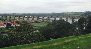
The Royal Border Bridge spans the River Tweed between Berwick-upon-Tweed and Tweedmouth in Northumberland, England. It is a Grade I listed railway viaduct built between 1847 and 1850, when it was opened by Queen Victoria. It was designed by Robert Stephenson for the York, Newcastle and Berwick Railway and remains in regular use as part of the East Coast Main Line. Despite its name, the bridge does not span the border between England and Scotland, which is approximately 3 miles (5 km) further north.
Barrow rail bridge,, is a pratt truss type of railway bridge that spans the river Barrow between County Kilkenny and County Wexford in the south east of Ireland. This rural landmark with a length of 2,131 ft (650 m) is the longest bridge on the river. It was second longest bridge in Ireland and the third longest rail bridge in the British Isles. Designed by Sir Benjamin Baker and built by the firm of Sir William Arrol. It is known locally as Barrow bridge.
The Craigmore Viaduct is a railway bridge near Bessbrook, County Armagh, Northern Ireland, known locally as the 18 Arches.. Near Newry railway station.

Laigh Milton Viaduct is a railway viaduct near Laigh Milton mill to the west of Gatehead in East Ayrshire, Scotland, about 5 miles (8 km) west of Kilmarnock. It is probably the world's earliest surviving railway viaduct on a public railway, and the earliest known survivor of a type of multi-span railway structure subsequently adopted universally.

Larpool Viaduct, also known as the Esk Valley Viaduct is a 13 arch brick viaduct built to carry the Scarborough & Whitby Railway over the River Esk, North Yorkshire, England.
The Ballochmyle Viaduct is the highest extant railway viaduct in Britain. It is 169 feet (52 m) high, and carries the railway over the River Ayr near Mauchline and Catrine in East Ayrshire, Scotland. It carries the former Glasgow and South Western Railway line between Glasgow and Carlisle.

The Chenab Bridge is an Indian railway steel and concrete arch bridge under construction between Bakkal and Kauri in the Reasi district of Jammu and Kashmir in India. When completed, the bridge will span the Chenab River at a height of 359 m (1,178 ft) above the river, making it the world's highest rail bridge. In November 2017 the base supports were declared completed allowing for the start of the construction of the main arch.

Stockport Viaduct carries the West Coast Main Line across the valley of the River Mersey in Stockport, Greater Manchester, England. It is one of the largest brick structures in the United Kingdom.
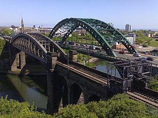
Monkwearmouth Railway Bridge is a railway bridge built in 1879, crossing the River Wear at Sunderland and Monkwearmouth. The bridge lies adjacent to and upstream of the Wearmouth Road Bridge.

Victoria Viaduct, originally known as the Victoria Bridge, is a stone arch rail viaduct spanning the River Wear about 1 mile (1.6 km) south-east of Washington in North East England. It was built as part of the Durham Junction Railway under the supervision of Thomas Elliot Harrison.

The London Road Viaduct is a brick railway viaduct in Brighton, part of the city of Brighton and Hove in East Sussex, England. It carries the East Coastway Line between Brighton and London Road railway stations. Built in the 1840s for the Brighton, Lewes and Hastings Railway by the locomotive engineer and railway architect John Urpeth Rastrick, the sharply curving structure has 27 arches and about 10 million bricks. It is still in constant use, and is listed at Grade II* for its historical and architectural significance.

Hengoed Viaduct is a Grade II* listed railway viaduct, located above the village of Maesycwmmer, in Caerphilly county borough, South Wales. Originally built to carry the Taff Vale Extension of the Newport, Abergavenny and Hereford Railway (NA&HR) across the Rhymney River, it is now part of National Cycle Route 47

The Newbattle Viaduct, sometimes also called the Lothianbridge, Newtongrange or Dalhousie Viaduct, carries the Borders Railway, which opened in 2015, over the River South Esk near Newtongrange, Midlothian, Scotland.

Dinting Viaduct is a 19th-century railway viaduct in Glossopdale in Derbyshire, England, that carries the Glossop Line over a valley at the village of Dinting. It crosses the Glossop Brook and the A57 road between Manchester and Sheffield.
The Laune Viaduct is a historic bridge in Killorglin, County Kerry, Ireland.

The Bowenfels rail viaducts are a series of heritage-listed railway viaducts and railway bridges over Farmers Creek on the Main Western line in Bowenfels, City of Lithgow, New South Wales, Australia. It was designed in two stages, by John Whitton as the Engineer-in-Chief for Railways, in 1870; and by engineering staff of New South Wales Government Railways in 1921; and was built from 1870 to 1921. It is also known as Farmers Creek viaducts. The property is owned by RailCorp, an agency of the Government of New South Wales. It was added to the New South Wales State Heritage Register on 2 April 1999. The viaduct are located approximately 159 kilometres (99 mi) west of Central railway station.
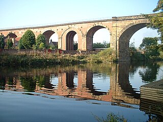
Yarm Viaduct carries railway traffic above the town of Yarm and across the River Tees straddling the boundary between North Yorkshire and County Durham in northern England. The railway it is situated on, runs between Northallerton and Eaglescliffe, and was opened in 1852 as part of the extension of the Leeds Northern Railway to Stockton-on-Tees. The line and viaduct are currently owned and maintained by Network Rail and carries passenger traffic for TransPennine Express and Grand Central train operating companies. It also sees a variety of freight traffic.

