Cape Town is the legislative capital of South Africa. It is the country's oldest city and the seat of the Parliament of South Africa. It is the country's second-largest city, after Johannesburg, and the largest in the Western Cape. The city is part of the City of Cape Town metropolitan municipality.
The N21 is a proposed national route in the City of Cape Town, South Africa. It is also known as the Peninsula Expressway ring road. Once complete, it will link the northern suburbs on the Atlantic seaboard with the southern suburbs on False Bay (Muizenberg). The R300 freeway is entirely part of the proposed route.

The N1 is a national route in South Africa that runs from Cape Town through Bloemfontein, Johannesburg, Pretoria and Polokwane to Beit Bridge on the border with Zimbabwe. It forms the first section of the famed Cape to Cairo Road.

The Karoo is a semi-desert natural region of South Africa. No exact definition of what constitutes the Karoo is available, so its extent is also not precisely defined. The Karoo is partly defined by its topography, geology and climate, and above all, its low rainfall, arid air, cloudless skies, and extremes of heat and cold. The Karoo also hosted a well-preserved ecosystem hundreds of million years ago which is now represented by many fossils.

Kannaland Municipality is a local municipality located within the Garden Route District Municipality, in the Western Cape province of South Africa. The municipal area is situated in the western part of the Little Karoo and includes the towns of Ladismith, Calitzdorp and Zoar. As of 2022, it has a population of 31,986. Its municipality code is WC041.

Laingsburg Municipality is a local municipality located in the Western Cape province of South Africa. As of 2022, the population is 11,366. Its municipality code is WC051.

The Swartberg mountains are a mountain range in the Western Cape province of South Africa. It is composed of two main mountain chains running roughly east–west along the northern edge of the semi-arid Little Karoo. To the north of the range lies the other large semi-arid area in South Africa, the Great Karoo. Most of the Swartberg Mountains are above 2000 m high, making them the tallest mountains in the Western Cape. It is also one of the longest, spanning some 230 km from south of Laingsburg in the west to between Willowmore and Uniondale in the east. Geologically, these mountains are part of the Cape Fold Belt.
The R323 is a Regional Route in South Africa that connects Riversdale in the south with Laingsburg in the north.

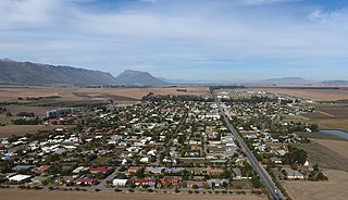
Laingsburg is a town located in the Western Cape province in South Africa. It is a relatively large agricultural town in the semi-arid Great Karoo; its economy is based on farming goats, sheep, fruits, and vegetable. The town is served by two main roads, namely the N1 and the R323.

Somerset West is a town in the Western Cape, South Africa. Organisationally and administratively it is included in the City of Cape Town metropolitan municipality Eastern Suburbs zone . The vehicle registration code for Somerset West is CFM and the post code is 7130 for street addresses, and 7129 for post office boxes.

Durbanville, previously called Pampoenkraal, is a town in the Western Cape province of South Africa, part of the greater Cape Town metropolitan area. It is a semi-rural residential suburb on the north-eastern outskirts of the metropolis surrounded by farms producing wine and wheat.

The Hex River Mountains make up the second highest mountain range in the Western Cape province of South Africa and are located 120 kilometres north-east of Cape Town. They form part of a large anticline in the Cape Fold Belt mountain system and form a north-east, south-west trending mountain system forming the core of the Cape Syntaxis between the towns of Worcester and De Doorns. They are mostly composed of Table Mountain sandstone and most peaks reach 2,000 metres in height or more. The highest mountain is Matroosberg at 2,249 metres, making it the second tallest peak in the province after Seweweekspoort Peak in the Swartberg Mountain Range.

The Hottentots Holland Mountains are part of the Cape Fold Belt in the Western Cape, South Africa. The mountain range forms a barrier between the Cape Town metropolitan area and the southern Overberg coast.

Seweweekspoortpiek is a peak in the Western Cape, South Africa. It is the highest mountain in the Cape Fold Belt and the highest point in the Western Cape province. Along with its western neighbour, Du Toits Peak, it qualifies as an Ultra and these are the only two in the country.
Porterville is a town in the Western Cape province of South Africa.

The Anysberg Nature Reserve of 62,500 ha, is situated in the western Little Karoo region of the Gouritz Cluster Biosphere Reserve in the Western Cape province, South Africa. The central mountain is named after Anise, Pimpinella anisum, which is found in the reserve. The reserve was established in 1984, to conserve succulent and fynbos flora in the Cape Fold Belt, and to reintroduce game which formerly occurred here.
Mpofu Nature Reserve is a nature reserve in the Amatole district of the Eastern Cape Province, South Africa that is managed by Eastern Cape Parks.
Prince Albert Road is a village located in Laingsburg Local Municipality, Western Cape.

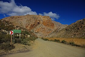
The Garcia's Pass is a mountain pass across the Langeberg in the Western Cape province of South Africa, with its highest point at 548 m (1,798 ft) altitude. The regional road numbered R323 uses this pass on its leg between Riversdale in the south and Ladismith in the Little Karoo to the north. From Riversdale, the road winds to the Garcia Pass across the Langeberg to Muiskraal in the northern foothills. The maximum slope is 1:14 on the southern descend.
The 1981 Laingsburg Flood was a catastrophic event that occurred on 25 January 1981 in the town of Laingsburg, Western Cape, South Africa. The flood killed at least 104 residents, and the bodies of 72 people were never found. A total of 184 houses were destroyed.