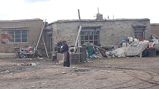
Duoma, Domar, or Duomaxiang is a village and township-level division of Shuanghu County in the Nagqu Prefecture of the Tibet Autonomous Region, in China. It is located roughly 140 kilometres (87 mi) west of Amdo Town and roughly 50 kilometres (31 mi) north of Siling Co, near the western bank of a lake at the foot of the Tanggula Mountains. As of 2004 it had a population of 1,488 people.
Gangnyi, Gangni, Gangnyixiang or Gangnixiang is a village and township-level division of Amdo County in the Nagqu Prefecture of the Tibet Autonomous Region, in China. It is located roughly 60 kilometres (37 mi) northwest of Amdo Town. The township covers an area of 5,019 kilometres (3,119 mi) and as of 2004 it had a population of about 1300. The principal economic activity is animal husbandry, pastoral yak, goat, sheep, and so on.
Lhari is a small town and seat of Lhari County in the Nagqu Prefecture of the Tibet Autonomous Region, in China. It is located northeast of Lhasa, southeast of Nagchu Town, southwest of Banbar Town and north of Gongbo'gyamda. As of 2004 it had a population of about 1,000.
Lingti, also Lindi or Lindixiang is a small town and township-level division of Lhari County in the Nagqu Prefecture of the Tibet Autonomous Region, in China. It lies along the S305 road, 105 kilometres (65 mi) northwest of Lhari Town and 100 kilometres (62 mi) southwest by road of Nagchu Town. As of 2004 it had a population of about 1100. The principal economic activity is animal husbandry, pastoral yak, goat, sheep, and so on. The town's name means "forest embankment".
Xarma, also Sharma, Xiama or Xiamaxiang is a small town and township-level division of Lhari County in the Nagqu Prefecture of the Tibet Autonomous Region, in China. It lies along the S305 road, 69.4 kilometres (43.1 mi) northwest of Lhari Town and 136 kilometres (85 mi) southwest by road of Nagchu Town. As of 2004 it had a population of about 1700. The principal economic activity is animal husbandry, pastoral yak, goat, sheep, and so on.
Zharen, also Zaring or Zharencun is a small town and township-level division of Amdo County in the Nagqu Prefecture of the Tibet Autonomous Region, in China. It is located at the side of the G109 road, 45 kilometres (28 mi) south of Amdo Town on the road from Nagchu Town, and approximately 20 kilometres (12 mi) east of the southern tip of Cona Lake.

Dayao is a rural town under the administration of and in the south of Liuyang, Hunan, China. Dayao is well known for its firework industry. Dayao has an area of 149.3-square-kilometre (57.6 sq mi). and a population of 91,300. Yanghua Township merged to Dayao on November 18, 2015. The town is bordered to the north by Hehua Subdistrict, to the east by Chengtanjiang Town, to the south by the towns of Jingang and Litian, and to the west by Chengchong Town.

Yongqing is a county in Hebei province, China. It is under the administration of the prefecture-level city of Langfang. It borders Guangyang District to the north, Anci District to the east, Bazhou to the south, and Gu'an County to the west, and has a population of 382,000 residing in an area of 774 km2 (299 sq mi).
Baidi is a small village in Baidi Township, Nagarzê County, Lhoka (Shannan) Prefecture, Tibet Autonomous Region, China. It is located at the western end of Yamdrok Lake. Near the village the Yamdrok Hydropower Station, the largest power station in Tibet, was completed and dedicated in 1996.
Leifeng is a subdistrict of Wangcheng District in Changsha City, Hunan Province, China. Leifeng's area is 82.4 km2 and its population is about 43,000. The place is named after a Chinese hero Lei Feng who was born here.
Baizhuang Township is a township of Shenze County, Hebei, China.
Anxiang is a township of Xingtang County, Hebei, China. Anxiang is located 7.4 kilometres (4.6 mi) south of the county seat and 56 kilometres (35 mi) by road north of Shijiazhuang.

Abei Township, also Abeixiang is a township-level division situated in the Jixi prefecture of Heilongjiang, China. It is located 120 kilometres (75 mi) by S309 and S211 roads northeast of Hulin. Established in 1979 under the jurisdiction of Hulin City, it has an area of almost 300 square kilometers and more than 11.2 million mu of arable land. It contains Xinancha Reservoir, which lies east of the main village towards Xiaomuhe.
Coka is a town in Banbar County, Chamdo Prefecture, in the east of the Tibet Autonomous Region, China. It lies just 5 km (3.1 mi) to the southwest of Banbar, and is serviced by Tibet Regional Highway 303 (S303). The administrative division covers an area of 451 km2 (174 sq mi), and as of 2004 had a population of 4,000.
Cuoma, or Cuomaxiang is a village and township-level division of Amdo County in the Nagqu Prefecture of the Tibet Autonomous Region, in China. It is located roughly 30 kilometres (19 mi) southwest of Amdo Town near the northern bank of Cona Lake. It covers an area of 5,098 square kilometres (1,968 sq mi) and as of 2004 had a population of about 3,100. Cuoma township of Amdo County has existed since 1960 and was further expanded in 1987, but Cuoma has also been listed under the jurisdiction of Seqing Township of Nyainrong County. The principal economic activity is animal husbandry, pastoral yak, goat, sheep, and so on.
Pana, also Pagnag is a small town and township-level division of Amdo County in the Nagqu Prefecture of the Tibet Autonomous Region, in China. It is located just outside Amdo Town. As of 2004 it had a population of about 2700, 683 of which were living in the town of Pana. The principal economic activity is animal husbandry, pastoral yak, goat, sheep, and so on. Blueschist outcrops are found in the area. The villagers in recent times organized a railway protecting committee to select locals to monitor the Qinghai-Tibet Railway.
Qiangma, also Qangma or Qiangmazhen is a small town and township-level division of Amdo County in the Nagqu Prefecture of the Tibet Autonomous Region, in China. It is located just south of Zi Getangcuo Lake, 90.7 kilometres (56.4 mi) southwest of Amdo Town. It covers an area of 5,467 square kilometres (2,111 sq mi) and as of 2004 it had a population of about 1700. The principal economic activity is animal husbandry, pastoral yak, goat, sheep, and so on.

Chengtanjiang Town is a suburban town under the administration of Liuyang City, Hunan Province, People's Republic of China. According to the 2015 census, it had a population of 65,100 and an area of 158.8-square-kilometre (61.3 sq mi). The town shares a border with Hehua Subdistrict to the northwest, Jingang Town to the southwest, Jinshan Town of Shangli County to the south, Wenjiashi Town to the southeast, Zhonghe Town to the east, and Gaoping Town to the north.

Guankou Subdistrict is an urban subdistrict and the seat of Liuyang City, Hunan Province, China. As of the 2015 census it had a population of 50,400 and an area of 161.8-square-kilometre (62.5 sq mi). Xijiang Township merged to Guankou subdistrict on November 18, 2015. The town is bordered to the northeast by Gugang Town, to the southeast by Gaoping Town, to the south by Hehua Subdistrict, to the west by Jiaoxi Township, to the northwest by Chunkou Town, and to the southwest by Jili Subdistrict.