| Location | |
|---|---|
| Xinjiang | |
| Country | China |
| Production | |
| Products | Coal |
The Sha'er Lake is a large coal field located in the north of China in Xinjiang. Sha'er Lake represents one of the largest coal reserve in China having estimated reserves of 89.2 billion tonnes of coal. [1]
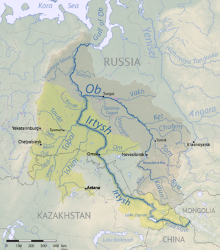
The Irtysh is a river in Russia, China, and Kazakhstan. It is the chief tributary of the Ob and is also the second longest tributary river in the world after Paraná River.

Dzungaria is a geographical subregion in Northwest China that corresponds to the northern half of Xinjiang. It is thus also known as Beijiang, which means "Northern Xinjiang". Bound by the Altai Mountains to the north and the Tian Shan mountain range to the south, Dzungaria covers approximately 777,000 km2 (300,000 sq mi), and borders Kazakhstan to the west and Mongolia to the east. In contexts prior to the mid-18th century Dzungar genocide, the term "Dzungaria" could cover a wider area, conterminous with the Oirat-led Dzungar Khanate.

Sanming, also known as Minzhong, is a prefecture-level city in western Fujian province, China. It borders Nanping City to the north, Fuzhou City to the east, Quanzhou City to the southeast, Longyan City to the south and the province of Jiangxi to the west. Sanming lies between Wuyi and Daiyun mountains.

Bosten Lake is a freshwater lake on the northeastern rim of the Tarim Basin, about 20 km (12 mi) east of Yanqi and 57 km (35 mi) northeast of Korla, Xinjiang, China in the Bayin'gholin Mongol Autonomous Prefecture. Covering an area of about 1,000 km2 (390 sq mi), it is the largest lake in Xinjiang and one of the largest inland freshwater lakes in China. Bosten lake receives water inflow from a catchment area of 56,000 km2 (22,000 sq mi).

Sayram Lake is a fresh water lake located near the border of Kazakhstan at the Tian Shan Mountains in Börtala Mongol Autonomous Prefecture, Xinjiang, China. The name Sayram originally derives from Kazakh, which means 'blessing'. The lake is also known as Santai Haizi and is the largest (458 km²) alpine lake in Xinjiang and also the highest at 2,070 m.

The Tarim Basin deciduous forests and steppe is a temperate broadleaf and mixed forests ecoregion in the Xinjiang Uyghur Autonomous Region of western China. The ecoregion includes deciduous riparian forests and steppes sustained by the region's rivers in an otherwise arid region.

Xainza County, also Shantsa, Shentsa, is a county within Nagqu of the Tibet Autonomous Region of China. In 1999 the county had a population of 16,190.

Yengisar County ; via Mandarin Chinese known as Yingjisha (Ying-chi-sha), is a county in the southwest of the Xinjiang Uyghur Autonomous Region. It is under the administration of the Kashgar Prefecture. It contains an area of 3,373 km2 (1,302 sq mi). As of the 2002 census, it had a population of 230,000.

Bohu County as the official romanized name, also transliterated from Uyghur as Bagrax County, is a county in the central part of the Xinjiang Uyghur Autonomous Region and is under the administration of the Bayin'gholin Mongol Autonomous Prefecture. It contains an area of 3,603 km2 (1,391 sq mi). According to the 2002 census, it has a population of 60,000.
The Kailuan (Group) Co., Ltd. is a major Chinese coal mining company. The Chinese Engineering and Mining Company was its predecessor.
Oil shale in China is an important source of unconventional oil. A total Chinese oil shale resource amounts of 720 billion tonnes, located in 80 deposits of 47 oil shale basins. This is equal to 48 billion tonnes of shale oil. At the same time there are speculations that the actual resource may even exceed the oil shale resource of the United States.

Mangnai also known as Mang'ai or Mangya is a county-level city in the northwest of Qinghai Province, China, bordering Xinjiang to the north and west. It is under the administration of Haixi Mongol and Tibetan Autonomous Prefecture. It is one of the most remote cities in China, the closest other city, Ruoqiang, is located 350 kilometres (220 mi) away. In 2018 it had a population of 63,000. The name Mangnai is based on the Mongolian word for 'forehead'.

Xinjiang, officially the Xinjiang Uygur Autonomous Region (XUAR), is an autonomous region of the People's Republic of China (PRC), located in the northwest of the country at the crossroads of Central Asia and East Asia. Being the largest province-level division of China by area and the 8th-largest country subdivision in the world, Xinjiang spans over 1.6 million square kilometres (620,000 sq mi) and has about 25 million inhabitants. Xinjiang borders the countries of Mongolia, Russia, Kazakhstan, Kyrgyzstan, Tajikistan, Afghanistan, Pakistan and India. The rugged Karakoram, Kunlun and Tian Shan mountain ranges occupy much of Xinjiang's borders, as well as its western and southern regions. The Aksai Chin and Trans-Karakoram Tract regions, both administered by China, are claimed by India. Xinjiang also borders the Tibet Autonomous Region and the provinces of Gansu and Qinghai. The most well-known route of the historic Silk Road ran through the territory from the east to its northwestern border.
The Karatash River, is south of Kashgar in the Kongur Tagh Range,, of the Xinjiang Uyghur Autonomous Region of China. It runs from near the eastern side of the 'Old Karatash Pass' (which is about 30 km southeast of Karakul lake, to the east and then northerly through the small Khirghiz villages of Shargut, Chat, Chimgan and Khan-Terek, flowing out into the Taklamakan Desert about halfway between Kashgar and Yangi Hissar.
"In a sense, the Karatash was very well-known historically, but only in its upper reaches. These lie on what seems to have been a standard trade route from Yarkand to Lake Karakul and beyond."

The Ying River is the largest tributary of the Huai River with its origin in Henan Province, People's Republic of China. From Zhoukou City in Henan the river flows through Fuyang City in Anhui Province then empties into the Huai River at Zhengyang.
The Zhunggar is a large coal field located in the north of China in Xinjiang. Zhunggar represents one of the largest coal reserve in China having estimated reserves of 10 billion tonnes of coal.
The East Junggar is a large coal field located in the north of China in Xinjiang. East Junggar represents one of the largest coal reserve in China having estimated reserves of 390 billion tonnes of coal.

Altun Shan National Nature Reserve is a large, arid area in the southeast of Xinjiang Autonomous Region, on the northern edge of the Tibetan plateau and the southern edge of the Tarim Basin in northwest China. It surrounds the Kumkol Basin, an endorheic basin in the western third of the Altyn-Tagh mountains. The reserve is sometimes referred to as the "Arjin Mountains Nature Reserve", or "Aerjinshan". The reserve covers the southern portions of Qiemo County and Ruoqiang County of Bayingolin Mongol Autonomous Prefecture in Xinjiang.
The Reserve Infantry Division of Xinjiang Military District(Chinese: 新疆军区陆军预备役步兵师) is a reserve infantry formation of the People's Liberation Army.
Xinjiang Guanghui Industry Investment Group Co., Ltd. is a major automotive sales, energy, mining, and real estate company based in the city of Ürümqi in the Xinjiang Autonomous Region of China. It was founded in 1989 by Sun Guangxin as a privately owned restaurant, nightclub, and recreational sports company, but entered the real estate development business in 1993. This subsidiary, Xinjiang Guanghui Real Estate Development, became the largest private real estate owner in Ürümqi.
| | This Chinese location article is a stub. You can help Wikipedia by expanding it. |
| | This article about mining is a stub. You can help Wikipedia by expanding it. |