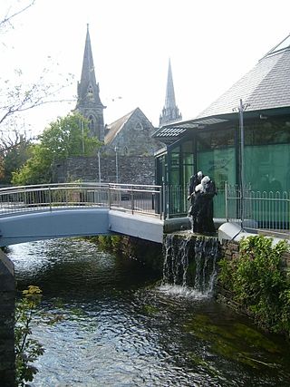
Clonakilty, sometimes shortened to Clon, is a town in County Cork, Ireland. The town is at the head of the tidal Clonakilty Bay. The rural hinterland is used mainly for dairy farming. The town's population as of 2016 was 4,592. The town is a tourism hub in West Cork, and was recognised as the "Best Town in Europe" in 2017, and "Best Place of the Year" in 2017 by the Royal Institute of the Architects of Ireland. Clonakilty is in the Dáil constituency of Cork South-West, which has three seats.
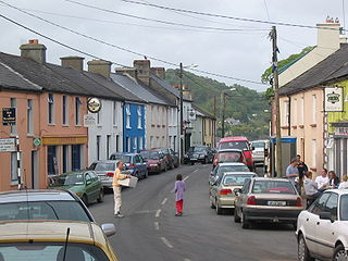
Union Hall, also Unionhall, is a small fishing village located in County Cork, Ireland, located on the west side of Glandore Harbour. Its nearest neighbour to the west is Castletownshend; to the east, Glandore village. It is approximately 10 kilometres south-east of Skibbereen. As of the 2016 census, 270 people were living in Union Hall.

West Cork is a tourist region and municipal district in County Cork, Ireland. As a municipal district, West Cork falls within the administrative area of Cork County Council, and includes the towns of Bantry, Castletownbere, Clonakilty, Dunmanway, Schull and Skibbereen, and the 'key villages' of Baltimore, Ballydehob, Courtmacsherry, Drimoleague, Durrus, Glengarriff, Leap, Rosscarbery, Timoleague and Union Hall.

Castlemartyr is a large village in County Cork, Ireland. It is around 30 kilometres (19 mi) east of Cork city, 10 km (6 mi) east of Midleton, 16 km (10 mi) west of Youghal and 6 km (4 mi) from the coast. Approximately 1,600 people live in the village and its hinterland. It is situated on the N25 national primary road and the R632 regional road.

Kanturk is a town in the north west of County Cork, Ireland. It is situated at the confluence of the Allua (Allow) and Dallow (Dalua) rivers, which stream further on as tributaries to the River Blackwater. It is about 50 kilometres from Cork, Blarney and Limerick, and lies just north of the main N72 road, 15 km from Mallow and about 40 km from Killarney. Kanturk is within the Cork North-West Dáil constituency.

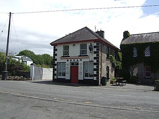
Darrara or Darrary is a rural townland near Clonakilty, County Cork in Ireland. The townland, of 1.4 km2 (0.54 sq mi), is home to Teagasc's Clonakilty Agricultural College and Sacred Heart Roman Catholic Church. Evidence of ancient settlement in the area include a restored Iron Age ringfort and a megalithic standing stone.

Clonegal, officially Clonegall, is a village in the southeast of County Carlow, Ireland. It is in a rural setting, close to the border between counties Wexford and Carlow, 5 km from Bunclody, County Wexford and 22 km from Carlow town. It is just over a mile north of where the River Slaney and the River Derry meet. Clonegal has a much smaller "twin" village across the River Derry in County Wexford, Watch House Village.

Ardfield, historically Ardofoyle, is a small village and civil parish on the south-west coast of County Cork, Ireland. It lies 8 kilometres south of Clonakilty and 11 kilometres east of Rosscarbery, near Galley Head. Ardfield's Roman Catholic church dates to 1832 and is within the ecclesiastical parish of Ardfield/Rathbarry.

Ballinadee is a village in County Cork, Ireland. It lies in the parish of Courceys, approximately 12 km by road west of Kinsale and 9 km south east of Bandon. Ballinadee is on the banks of the River Pound, which flows into the River Bandon, and has a school, two churches and two pubs.

Durrus is a village and civil parish in West Cork in Ireland. It is situated ten kilometres (6 mi) from Bantry in County Cork, at the head of the Sheep's Head and the Mizen Head peninsulas.
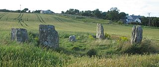
Templebryan Stone Circle is a stone circle, located 2.5 km (1.6 mi) north of Clonakilty, County Cork, Ireland. Grid ref: W386 438. Close by lies an Early Christian site.

Kilmore or Killmore, locally pronounced 'Kilmoor', is a village and townland in south County Wexford, Ireland, about 16 kilometres (9.9 mi) from Wexford town.

Watergrasshill is a village in north east County Cork in Ireland. Watergrasshill is within the Cork North-Central Dáil constituency. Bypassed in 2003, the village is situated on the R639 road and accessible via junction 17 of the M8 motorway. The 2016 census recorded a population of 1,346.

Street or Streete is a village and parish in County Westmeath, Ireland. It lies on the regional road between Lismacaffery and Rathowen. Its Irish name was historically anglicised as Straid or Strade.

Farran is a village in County Cork, Ireland, in the parish of Ovens. It lies on the southside of the River Lee. Farran is 12 miles (19 km) west from Cork City on the N22 road.
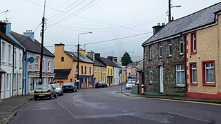
Drimoleague is a village on the R586 road at its junction with the R593 in County Cork, Ireland. It lies roughly halfway between the towns of Dunmanway and Bantry, within the civil parish of Dromdaleague. As of the 2016 census of Ireland, Drimoleague had 451 residents.
Ballinderry is a village and a townland in the historical Barony of Ormond Lower, County Tipperary, Ireland. It is located between Terryglass and Nenagh where the R493 road crosses the Ballyfinboy River.

The Battle of the Big Cross was a military engagement of the Irish Rebellion of 1798 between a force of United Irishmen rebels and a column of government troops. It was fought on 19 June 1798 on a spot on the Shannonvale-Ballinascarty road known locally as the "Big Cross", approximately four miles east of Clonakilty in West Cork. It was the only battle fought in the rebellion in County Cork.

Matehy is a civil parish in the historical barony of Muskerry East in County Cork, Ireland. The civil parish is centred on a small settlement, also referred to as Matehy, which contains a Roman Catholic church, a national (primary) school, and pub. Evidence of ancient settlement in the area include ringfort sites in Gilcagh townland, and a circular ecclesiastical enclosure containing the remains of a church and a number of 18th century gravestones.
