
Small hydro is the development of hydroelectric power on a scale suitable for local community and industry, or to contribute to distributed generation in a regional electricity grid. Exact definitions vary, but a "small hydro" project is less than 50 megawatts (MW), and can be further subdivide by scale into "mini" (<1MW), "micro" (<100 kW), "pico" (<10 kW). In contrast many hydroelectric projects are of enormous size, such as the generating plant at the Three Gorges Dam at 22,500 megawatts or the vast multiple projects of the Tennessee Valley Authority.

Hydroelectricity, or hydroelectric power, is electricity generated from hydropower. Hydropower supplies one sixth of the world's electricity, almost 4500 TWh in 2020, which is more than all other renewable sources combined and also more than nuclear power. Hydropower can provide large amounts of low-carbon electricity on demand, making it a key element for creating secure and clean electricity supply systems. A hydroelectric power station that has a dam and reservoir is a flexible source, since the amount of electricity produced can be increased or decreased in seconds or minutes in response to varying electricity demand. Once a hydroelectric complex is constructed, it produces no direct waste, and almost always emits considerably less greenhouse gas than fossil fuel-powered energy plants. However, when constructed in lowland rainforest areas, where part of the forest is inundated, substantial amounts of greenhouse gases may be emitted.

Wyangala Dam is a major gated rock fill with clay core embankment and gravity dam with eight radial gates and a concrete chute spillway across the Lachlan River, located in the south-western slopes region of New South Wales, Australia. The dam's purpose includes flood mitigation, hydro-power, irrigation, water supply and conservation. The impounded reservoir is called Lake Wyangala.

The Nurek Dam is an earth-fill embankment dam on the Vakhsh River in Tajikistan. Its primary purpose is hydroelectric power generation and its power station has an installed capacity of 3,015 MW. Construction of the dam began in 1961 and the power station's first generator was commissioned in 1972. The last generator was commissioned in 1979 and the entire project was completed in 1980 when Tajikistan was still a republic within the Soviet Union, becoming the tallest dam in the world at the time. At 304 m (997 ft), it is currently the second tallest man-made dam in the world, after being surpassed by Jinping-I Dam in 2013. The Rogun Dam, also along the Vakhsh in Tajikistan, may exceed it in size when completed.

Nagarjuna Sagar Dam is a masonry dam across the Krishna River at Nagarjuna Sagar which straddles the border between Palnadu district in Andhra Pradesh and Nalgonda district in Telangana. The dam provides irrigation water to the districts of Palnadu, Guntur, Nalgonda, Prakasam, Khammam, Krishna, and parts of West Godavari. It is also a source of electricity generation for the national grid.

The Blowering Dam is a major ungated rock fill with clay core embankment dam with concrete chute spillway impounding a reservoir under the same name. It is located on the Tumut River upstream of Tumut in the Snowy Mountains region of New South Wales, Australia. Purposes for the dam include flood mitigation, hydro-power, irrigation, water supply and conservation. The dam is part of the Snowy Mountains Scheme, a vast hydroelectricity and irrigation complex constructed in south-east Australia between 1949 and 1974 and now run by Snowy Hydro.

The Indira Sagar Dam is the largest dam in India, in terms of volume of water stored in the reservoir. It is located on the Narmada River at the town of Narmada Nagar, Punasa in the Khandwa district of Madhya Pradesh in India. The foundation stone of the project was laid by the prime minister of India Indira Gandhi on 23 October 1984. The construction of the main dam started in 1992. The downstream projects of ISP are Omkareshwar, Maheshwar, and Sardar Sarovar Project. To build it, a town of 22,000 people and 100 villages was displaced.

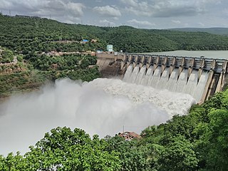
Hirakud Dam is built across the Mahanadi River, about 15 kilometres (9 mi) from Sambalpur in the state of Odisha in India. It is the longest earthen dam in the world. Behind the dam extends a lake, Hirakud Reservoir, 55 km (34 mi) long. It is one of the first major multipurpose river valley projects started after India's independence. Hirakud Reservoir was declared a Ramsar site on 12 October 2021.

The Kajaki Dam is "an earth and rockfill embankment type dam" located on the Helmand River in the Kajaki District of Helmand Province in Afghanistan, about 161 km (100 mi) northwest of Kandahar. It has a hydroelectric power station, which is operated by the Helmand and Arghandab Valley Authority through the Ministry of Energy and Water.
The Srisailam Dam is constructed across the Krishna River in Nandyal district, Andhra Pradesh and Nagarkurnool district, Telangana near Srisailam temple town and is the 2nd largest capacity working hydroelectric station in India.

Lake Qaraoun is an artificial lake or reservoir located in the southern region of the Beqaa Valley, Lebanon. It was created near Qaraoun village in 1959 by building a 61 m-high (200 ft) concrete-faced rockfill dam in the middle reaches of the Litani River. The reservoir has been used for hydropower generation, domestic water supply, and for irrigation of 27,500 ha.

The Farkhad Dam is a hydroelectric and irrigation dam on the Spitamen in Sughd Province, Tajikistan. It is a part of the Naryn-Syr Darya Cascade. The dam is located on the territory of Tajikistan and controlled by Tajikistan, while the Farkhad hydropower station, operated by Uzbekenergo.

The Queen Sirikit Dam is an embankment dam on the Nan River, a tributary of the Chao Phraya River, in Tha Pla District, Uttaradit Province, Thailand. It is at the southeastern edge of the Phi Pan Nam Range. The dam was built for the purpose of irrigation, flood control and hydroelectric power production. It is named after Sirikit, Queen of Thailand.
The Koteshwar Dam is a gravity dam on the Bhagirathi River, located 22 km (14 mi) downstream of the Tehri Dam in Tehri District, Uttarakhand, India. The dam is part of the Tehri Hydropower Complex and serves to regulate the Tehri Dam's tailrace for irrigation and create the lower reservoir of the Tehri Pumped Storage Power Station. In addition, the dam has a 400 MW run-of-the-river power station. The project was approved in 2000 and its first generator was commissioned on 27 March 2011, the second on 30 March 2011. The construction site had been inundated in September 2010 by floods. The diversion tunnel was later blocked heaving/collapse of the hill in December 2010. The spillway was commissioned in Jan, 2011. The last two generators were made operational in March 2012.

The Sup'ung Dam, also referred to as the Shuifeng Dam and originally the Suihō Dam, is a gravity dam on the Yalu River between Kuandian Manchu Autonomous County, Liaoning Province in China and Sakju County, North Pyongan Province in North Korea. The dam was constructed by the Japanese between 1937 and 1943 in order to generate electricity and has been repaired and renovated several times throughout the years, mainly due to spillway damage from flooding.
The Cirata Dam is an embankment dam on the Citarum River in West Java, Indonesia. It is located 100 km (62 mi) southeast of Jakarta. It was constructed between 1984 and 1988 for the primary purpose of hydroelectric & photovoltaic power generation. Other purposes include flood control, aquaculture, water supply and irrigation. The 125 m (410 ft) tall concrete-face rock-fill dam is situated just before a sharp bend in the river and withholds a reservoir with a gross storage capacity of 2,165,000,000 m3 (1,755,194 acre⋅ft). The reservoir has a surface area of 62 km2 (24 sq mi) which caused the relocation of 6,335 families. The construction of the dam resulted in involuntary resettlement of 56,000 people.
The Bowatenna Dam is a 100 ft (30 m) high gravity dam at Bowatenna, in Central Province of Sri Lanka. The dam was built in June 1981, and is used primarily for irrigation. A 40 MW power station is also constructed 5,800 ft (1,800 m) downstream, for hydroelectric power generation.

The Gal Oya Dam is an embankment dam in the Uva Province of Sri Lanka. The dam creates one of the largest reservoirs in the country, the Gal Oya Reservoir. Water from the reservoir is used primarily for irrigation in the Uva and Eastern provinces, in addition to powering a small hydroelectric power station. Construction of the dam and reservoir began in August 24, 1949, completing four years later in 1953.

Aguieira Dam also known as Foz do Dão Dam is a concrete multiple arch dam on the Mondego River, where the river forms the border line between the districts of Coimbra and Viseu. It is located in the municipality Penacova, in Coimbra District, Portugal.

Sergeyev Dam or Sergeyevka Dam is a gravity dam in Shal akyn District, North Kazakhstan Region, Kazakhstan.

