
Torquay is a seaside town in Devon, England, part of the unitary authority area of Torbay. It lies 18 miles (29 km) south of the county town of Exeter and 28 miles (45 km) east-north-east of Plymouth, on the north of Tor Bay, adjoining the neighbouring town of Paignton on the west of the bay and across from the fishing port of Brixham.
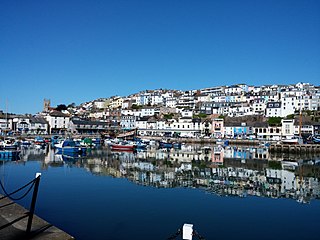
Brixham is a fishing town and civil parish in the district of Torbay in the county of Devon, in the south-west of England. Brixham is at the southern end of Torbay, across the bay from Torquay, and fishing and tourism are the major industries of the town. At the time of the 2011 census it had a population of 16,693.

Torbay is a borough in Devon, England, administered by the unitary authority of Torbay Council. It consists of 62.87 square kilometres (24.27 sq mi) of land, spanning the towns of Torquay, Paignton and Brixham, against an east-facing natural harbour Tor Bay of the Lyme Bay sheltered part of the English Channel. A popular tourist destination with a tight conurbation of resort towns, Torbay's sandy beaches, mild climate and recreational and leisure attractions have given rise to the nickname of the English Riviera.

The South West Coast Path is England's longest waymarked long-distance footpath and a National Trail. It stretches for 630 miles (1,014 km), running from Minehead in Somerset, along the coasts of Devon and Cornwall, to Poole Harbour in Dorset. Because it rises and falls with every river mouth, it is also one of the more challenging trails. The total height climbed has been calculated to be 114,931 ft (35,031 m), almost four times the height of Mount Everest. It has been voted 'Britain's Best Walking route' twice in a row by readers of The Ramblers' Walk magazine, and regularly features in lists of the world's best walks.
The River Otter rises in the Blackdown Hills just inside the county of Somerset, England near Otterford, then flows south through East Devon. It enters the English Channel at the western end of Lyme Bay, part of the Jurassic Coast, a UNESCO World Heritage Site. The Permian and Triassic sandstone aquifer in the Otter Valley is one of Devon's largest groundwater sources, supplying drinking water to 200,000 people.

The Erme is a river in south Devon, England. From its source on Dartmoor it flows in a generally southerly direction past some of the best-preserved archaeological remains on the moor. It leaves the moor at the town of Ivybridge and continues southward, passing the settlements of Ermington, Modbury and Holbeton. Near Holbeton it becomes a ria and empties into the English Channel in Bigbury Bay, between the rivers Yealm and Avon.

The Dartmouth Steam Railway, formerly known as the Paignton and Dartmouth Steam Railway, is a 6.7-mile (10.8 km) heritage railway on the former Great Western Railway branch line between Paignton and Kingswear in Devon, England. Much of the railway's business is from summer tourists from the resorts of Torbay, who travel to Kingswear, where the Dartmouth Passenger Ferry takes them across the River Dart to Dartmouth.

The Riviera Line is the railway between the city of Exeter, towns Dawlish, Teignmouth, and the "English Riviera" resorts of Torbay in Devon, England. Its tracks are shared with the Exeter to Plymouth Line along the South Devon sea wall. It is part of the Network Rail Route 12.

Mortehoe is a village and former manor on the north coast of Devon, England. It lies 10 miles north-west of Barnstaple, near Woolacombe and Lee Bay, and is sited in a valley within the hilly sand-dune-like land behind Morte Point, almost directly above Woolacombe. The parish population at the 2011 census was 1,637.

Berry Head is a coastal headland that forms the southern boundary of Tor Bay in Devon, England. Lying to the east of the town of Brixham, it is a national nature reserve and a local nature reserve. Berry Head To Sharkham Point is a Site of Special Scientific Interest.
St. Mary's Bay is a sand and shingle beach located near the fishing town of Brixham, Devon, England. It has footpath access from a car park and can be reached as a detour from a walk along the coast path. There is a viewpoint on Sharkham Point above the beach. Fossils can be found here.

Mount Edgcumbe House is a stately home in south-east Cornwall and is a Grade II listed building, whilst its gardens and parkland are listed as Grade I in the Register of Parks and Gardens of Special Historic Interest in England.

Churston railway station is on the Dartmouth Steam Railway, a heritage railway in Torbay, Devon, England. It is situated beside the main road to Brixham and close to the villages of Churston Ferrers and Galmpton.
Brixham Battery and Battery Gardens are an open space on the sea shore in Brixham, Devon at grid reference SX920569. They are a traditional observation point for Brixham trawler races, both past and present.

Galmpton is a semi-rural village in Torbay, in the ceremonial county of Devon, England. It is located in the ward of Churston-with-Galmpton and the historic civil parish of Churston Ferrers, though some areas historically considered parts of Galmpton, such as Greenway and Galmpton Creek, are situated in the Devon borough of South Hams.

NCI Froward Point is a busy National Coastwatch Institution (NCI) lookout station at Inner Froward Point at the easterly side of the mouth of the River Dart two miles by coast path from Kingswear in Devon in England. Its twin duties are to maintain an hours of daylight watch over the local coastal area and the South West Coast Path on whose route it lies. With some significant blind spots because of the coastline, NCI Froward Point covers the coastline from Start Point in the West towards Brixham in the East.

Martinhoe is a small settlement and civil parish in North Devon district of Devon, England. Martinhoe is within the Exmoor National Park, the smallest National Park in England. In the 2011 census Martinhoe Parish was recorded as having a population of 159. Martinhoe is in the Combe Martin ward, for elections to the district council. Martinhoe's local government takes the form of a parish meeting and as such has no parish council nor elected parish councillors.

Sharkham Point Iron Mine was an iron mine at Sharkham Point, near the town of Brixham in Devon. The mine was worked for around 125 years and employed at its peak 100 workers. It was primarily an open cast mine, but five shafts and six adits are also mentioned in reports of the site. Some are still accessible today, but since the area was used as a rubbish tip in the 1950s and 60s, much of the archaeology has been covered over.

Brixham Town Hall is a municipal building in New Street, Brixham, Devon, England. The structure, which is the meeting place of Brixham Town Council, is a Grade II listed building.
