
Dartmoor is an upland area in southern Devon, South West England. The moorland and surrounding land has been protected by National Park status since 1951. Dartmoor National Park covers 954 km2 (368 sq mi).
William Crossing (1847–1928) was a writer and chronicler of Dartmoor and the lives of its inhabitants. He lived successively at South Brent, Brentor and at Mary Tavy but died at Plymouth, Devon.

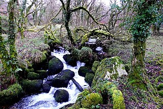
The Walkham is a river whose source is on Dartmoor, Devon, England. It rises in the wide gap between Roos Tor and Great Mis Tor and flows almost due south for approximately 3 miles (4.8 km) leaving the tors and thus National Park behind then south-west for 1 mile (1.6 km) past Woodtown. The river then reaches a village, Horrabridge, with a small compact network of streets mainly on the south or left bank. It receives most of its tributaries which are unnamed headwaters along its south-flowing inception, draining the near side of two series of six tors (peaks) to the west ending in Pew Tor at 320 metres and likewise to the east ending in Leeden Tor at 389 metres. In absolute distance, 2 miles (3.2 km) west of the village and the same south of the small well-preserved town of Tavistock by a footbridge on the West Devon Way the Walkham joins the Tavy which discharges into the Tamar Estuary north of the Plymouth conurbation after a fast descent around wide hillsides, a few miles south.

High Willhays, or according to some authorities High Willes, is the highest point on Dartmoor, Devon, at 621 metres above sea level, and the highest point in Southern England.

The Dartmoor longhouse is a type of traditional stone-built home, typically found on the high ground of Dartmoor, in Devon, England and belonging to a wider tradition of combining human residences with those of livestock under a single roof specific to western Britain; Wales, Cornwall and Devon, where they are more usually referred to simply as longhouses and in general housebarns.

Fox Tor is a relatively minor tor on Dartmoor in the county of Devon, England.

Rough Tor, or Roughtor, is a tor on Bodmin Moor, Cornwall, England, United Kingdom. The site is composed of the tor summit and logan stone, a neolithic tor enclosure, a large number of Bronze Age hut circles, and some contemporary monuments.

The Dartmoor crosses are a series of stone crosses found in Dartmoor National Park in the centre of Devon, England. Many of them are old navigational aids, needed because of the remoteness of the moorland and its typically bad weather. Some mark medieval routes between abbeys. Other crosses were erected as memorials, for prayer, as town or market crosses, in churchyards, and as boundary markers. The crosses were erected over a long period of time, some as recently as 100 years ago, the earliest probably almost 1,000 years ago.
Dartmoor Forest is a civil parish in Devon, England. It was formed in 1987 by the splitting of the former parish of Lydford. It covers about 56,000 acres (230 km2) entirely within Dartmoor National Park, and is the largest parish in Devon. Despite its size its population in 2001 was only 1,619. Due to its large size it is surrounded by many other parishes: these are, clockwise from the north, Belstone, South Tawton, Throwleigh, Gidleigh, Chagford, North Bovey, Manaton, Widecombe in the Moor, Holne, West Buckfastleigh, Dean Prior, South Brent, Ugborough, Harford, Cornwood, Shaugh Prior, Sheepstor, Walkhampton, Whitchurch, Peter Tavy, Lydford, land common to the parishes of Bridestowe and Sourton, and Okehampton Hamlets.

Sharptor is a hamlet west of Henwood in the civil parish of Linkinhorne in east Cornwall, England, United Kingdom. It is named after Sharp Tor on Bodmin Moor. Sharptor is close to Minions to the south, Kingbeare in the north and Darleyford to the east. Sharptor is around 280 metres (920 ft) above sea level.

Hawk's Tor is a hill and tor on Bodmin Moor in Cornwall, England, UK. Its summit is 307 metres (1,007 ft) above sea level.
The Walla Brook is the name of four different streams on Dartmoor, England:

Hookney Tor is a tor, situated on Dartmoor in Devon, England.
This article describes the geology of Dartmoor National Park in Devon, in south-west England. Dartmoor gained national park status in 1951 but the designated area of 954 km2 (368 sq mi) extends beyond the upland of Dartmoor itself to include much of the surrounding land, particularly in the northeast. The geology of the national park consists of a 625 km2 (241 sq mi) core of granite intruded during the early Permian period into a sequence of sedimentary rocks originating in the Devonian and Carboniferous periods. These rocks were faulted and folded, sometimes, intensely, during the Variscan orogeny. Thermal metamorphism has also taken place around the margins of the granite pluton altering the character of the sedimentary rocks whilst mineral veins were emplaced within the granite. A small outlier of Palaeogene sediments occurs on the eastern boundary of the national park.
Rattle Brook is a brook in north Dartmoor in Devon in south-west England. It is situated East of Great Links Tor, and rises by the Rattlebrook Peatworks on remote moorland in the western section of Dartmoor National Park. It flows past Bleak House with Green Tor to the east and Higher and Lower Dunna Goat Tors to the west. It runs between Amicombe Hill and Rattlebrook Hill to join the River Tavy at the mouth of Tavy Cleave.