
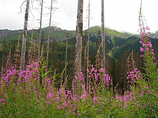
A forest is an area of land dominated by trees. Hundreds of definitions of forest are used throughout the world, incorporating factors such as tree density, tree height, land use, legal standing, and ecological function. The United Nations' Food and Agriculture Organization (FAO) defines a forest as, "Land spanning more than 0.5 hectares with trees higher than 5 meters and a canopy cover of more than 10 percent, or trees able to reach these thresholds in situ. It does not include land that is predominantly under agricultural or urban use." Using this definition, Global Forest Resources Assessment 2020 found that forests covered 4.06 billion hectares, or approximately 31 percent of the world's land area in 2020.

Quercus kelloggii, the California black oak, also known as Kellogg oak, is an oak in the red oak section, native to western North America. Although genetically separated from them for more than 20 million years, its leaves are remarkably similar in appearance to several other members of the red oak section including the red oak and the black oak found in eastern and central North America.
A woodland is, in the broad sense, land covered with trees, or in a narrow sense, synonymous with wood, a low-density forest forming open habitats with plenty of sunlight and limited shade. Woodlands may support an understory of shrubs and herbaceous plants including grasses. Woodland may form a transition to shrubland under drier conditions or during early stages of primary or secondary succession. Higher-density areas of trees with a largely closed canopy that provides extensive and nearly continuous shade are often referred to as forests.

Coppicing is a traditional method of woodland management which exploits the capacity of many species of trees to put out new shoots from their stump or roots if cut down. In a coppiced wood, which is called a copse, young tree stems are repeatedly cut down to near ground level, resulting in a stool. New growth emerges, and after a number of years, the coppiced tree is harvested, and the cycle begins anew. Pollarding is a similar process carried out at a higher level on the tree in order to prevent grazing animals from eating new shoots. Daisugi, is a similar Japanese technique.

Bocage is a terrain of mixed woodland and pasture characteristic of parts of Northern France, Southern England, Ireland, the Netherlands and Northern Germany, in regions where pastoral farming is the dominant land use.

A savanna or savannah is a mixed woodland-grassland ecosystem characterised by the trees being sufficiently widely spaced so that the canopy does not close. The open canopy allows sufficient light to reach the ground to support an unbroken herbaceous layer consisting primarily of grasses. According to Britannica, there exists four savanna forms; savanna woodland where trees and shrubs form a light canopy, tree savanna with scattered trees and shrubs, shrub savanna with distributed shrubs, and grass savanna where trees and shrubs are mostly nonexistent.

Quercus suber, commonly called the cork oak, is a medium-sized, evergreen oak tree in the section Quercus sect. Cerris. It is the primary source of cork for wine bottle stoppers and other uses, such as cork flooring and as the cores of cricket balls. It is native to southwest Europe and northwest Africa. In the Mediterranean basin the tree is an ancient species with fossil remnants dating back to the Tertiary period.

Oxleas Wood is one of the few remaining areas of ancient deciduous forest in Eltham in the Royal Borough of Greenwich, in southeast London. Some parts date back over 8,000 years to the end of the last ice age, the Younger Dryas. It is part of a larger continuous area of woodland and parkland on the south side of Shooter's Hill: other parts are Jack Wood, Castle Wood, Oxleas Meadows, Falconwood Field, Eltham Common and Eltham Park North. Eltham Park North includes the ancient Shepherdleas Wood.

In the United Kingdom, an ancient woodland is a woodland that has existed continuously since 1600 or before in England, Wales and Northern Ireland. Planting of woodland was uncommon before those dates, so a wood present in 1600 is likely to have developed naturally.

Hurstpierpoint is a village in West Sussex, England, 4 miles (6.4 km) southwest of Burgess Hill, and 1.5 miles (2.4 km) west of Hassocks railway station. It sits in the civil parish of Hurstpierpoint and Sayers Common which has an area of 2029.88 ha and a population of 7,112.

Hassocks is a large village and civil parish in the Mid Sussex District of West Sussex, England. Its name is believed to derive from the tufts of grass found in the surrounding fields.

Yardley Chase is a 357.6-hectare (884-acre) biological Site of Special Scientific Interest, mostly in Northamptonshire, with a small area in the south of the site in Buckinghamshire. It is in two areas of woodland, pasture and parkland, south-west of Yardley Hastings in Northamptonshire, and north-west of Olney in Buckinghamshire.
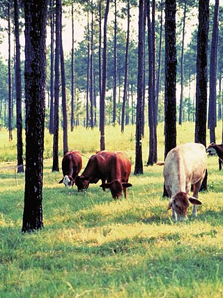
Silvopasture is the practice of integrating trees, forage, and the grazing of domesticated animals in a mutually beneficial way. It utilizes the principles of managed grazing, and it is one of several distinct forms of agroforestry.
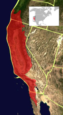
The California Floristic Province (CFP) is a floristic province with a Mediterranean-type climate located on the Pacific Coast of North America with a distinctive flora similar to other regions with a winter rainfall and summer drought climate like the Mediterranean Basin. This biodiversity hotspot is known for being the home of the Sierran giant sequoia tree and its close relative the coast redwood. In 1996, the Province was designated as a biodiversity hotspot allowing it to join ranks among 33 other areas in the world with many endemic species. To be named a biodiversity hotspot, an area has to contain species and plant life that cannot be found anywhere else in the world. The California Floristic Province is home to over 3,000 species of vascular plants, 60% of which are endemic to the province.

Faidherbia is a genus of leguminous plants containing one species, Faidherbia albida, which was formerly widely included in the genus Acacia as Acacia albida. The species is native to Africa and the Middle East and has also been introduced to Pakistan and India. Common names include apple-ring acacia, and winter thorn. The South African name is ana tree.

Wistman's Wood is one of three remote high-altitude oakwoods on Dartmoor, Devon, England.
Lowland heath is a Biodiversity Action Plan habitat as it is a type of ancient wild landscape. Natural England's Environmental Stewardship scheme describes lowland heath as containing dry heath, wet heath and valley mire communities, usually below 250 metres (820 ft) in altitude, on acidic soils and shallow peat, typically comprising heathers, gorses, fine grasses, wild flowers and lichens in a complex mosaic. Heathers and other dwarf shrubs usually account for at least 25% of the ground cover. By contrast, upland heath, which is above 300 metres (980 ft) in altitude, is called moorland, Dartmoor being an example.

A dehesa is a multifunctional, agrosylvopastoral system and cultural landscape of southern and central Spain and southern Portugal; in Portugal, it is known as a montado. Its name comes from the Latin 'defensa' (fenced) referring to land that was fenced, and usually destined for pasture. Dehesas may be private or communal property. Used primarily for grazing, they produce a variety of products, including non-timber forest products such as wild game, mushrooms, honey, cork, and firewood. They are also used to raise the Spanish fighting bull and the Iberian pig. The main tree component is oaks, usually holm and cork. Other oaks, including melojo and quejigo, may be used to form dehesa, the species utilized depending on geographical location and elevation. Dehesa is an anthropogenic system that provides not only a variety of foods, but also wildlife habitat for endangered species such as the Spanish imperial eagle.

The Clyde Valley Woodlands National Nature Reserve (NNR) comprises six separate woodland sites in the Clyde Valley region of South Lanarkshire, Scotland. These six sites are located along a 12 km section of the River Clyde and its tributaries, and lie close to built-up areas such as Hamilton and Lanark on the southern outskirts of Greater Glasgow. The sites can be easily accessed by about two million people living in the surrounding urban areas, making the reserve unique amongst Scotland's NNRs, most of which tend to be located in more remote areas. The six sites are:
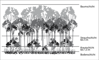
Stratification in the field of ecology refers to the vertical layering of a habitat; the arrangement of vegetation in layers. It classifies the layers of vegetation largely according to the different heights to which their plants grow. The individual layers are inhabited by different animal and plant communities (stratozones).