
Opal is a hydrated amorphous form of silica (SiO2·nH2O); its water content may range from 3% to 21% by weight, but is usually between 6% and 10%. Due to the amorphous (chemical) physical structure, it is classified as a mineraloid, unlike crystalline forms of silica, which are considered minerals. It is deposited at a relatively low temperature and may occur in the fissures of almost any kind of rock, being most commonly found with limonite, sandstone, rhyolite, marl, and basalt.

Canadian Pacific Hotels (CPH) was a division of the Canadian Pacific Railway (CPR) that primarily operated hotels across Canada, since passenger revenue made a significant contribution to early railway profitability. CPR restructured the division as a subsidiary in 1963. In 1988, CPR purchased the Canadian National Hotels chain, making Canadian Pacific Hotels and Resorts the nation's largest hotel owner. In 1998, all CPH properties were branded as either Fairmont or Delta.

A recreational vehicle park or caravan park is a place where people with recreational vehicles can stay overnight, or longer, in allotted spaces known as "sites" or "campsites". They are also referred to as campgrounds, though a true campground also provides facilities for tent camping; many facilities calling themselves "RV parks" also offer tent camping or cabins with limited facilities.
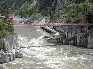
Hells Gate is an abrupt narrowing of British Columbia's Fraser River, located immediately downstream of Boston Bar in the southern Fraser Canyon. The towering rock walls of the Fraser River plunge toward each other forcing the waters through a passage only 35 metres (115 ft) wide. It is also the name of the rural locality at the same location.
Cassidy is an unincorporated community straddling Haslam Creek. near the east coast of southern Vancouver Island, British Columbia, Canada. The location on BC Highway 19 is about 98 kilometres (61 mi) by road north-west of Victoria, and 14 kilometres (9 mi) south of Nanaimo.

Fairmont Hot Springs is an unincorporated resort community located in south-eastern British Columbia, Canada commonly referred to as Fairmont. The community had a reported population of 781 in the 2021 census, but the town receives frequent tourists. The local resort is centered around a soak pool and swimming pool fed by natural mineral hot springs. The original springs building, surrounded by hot spring water seeping out of the ground, still stands.
The Skatin First Nations, aka the Skatin Nations, are a band government of the In-SHUCK-ch Nation, a small group of the larger St'at'imc people who are also referred to as Lower Stl'atl'imx. The Town of Skatin - the St'at'imcets version of the Chinook Jargon Skookumchuck- is located 4 km south of T'sek Hot Spring- alt. spelling T'sek Hot Spring - commonly & formerly named both St. Agnes' Well & Skookumchuck Hot Springs The community is 28 km south of the outlet of Lillooet Lake on the east side of the Lillooet River. It is approximately 75 km south of the town of Pemberton and the large reserve of the Lil'wat branch of the St'at'imc at Mount Currie. Other bands nearby are Samahquam at Baptiste Smith IR on the west side of the Lillooet River at 30 km. and Xa'xtsa First Nations; the latter is located at Port Douglas, near the mouth of the Lillooet River where it enters the head of Harrison Lake. The N'Quatqua First Nation on Anderson Lake, between Mount Currie and Lillooet, was at one time involved in joint treaty negotiations with the In-SHUCK-ch but its members have voted to withdraw, though a tribal council including the In-SHUCK-ch bands and N'Quatqua remains, the Lower Stl'atl'imx Tribal Council.

A quiggly hole, also known as a pit-house or simply as a quiggly or kekuli, is the remains of an earth lodge built by the First Nations people of the Interior of British Columbia and the Columbia Plateau in the United States. The word quiggly comes from a mispronunciation of the nsyilxcǝn term qʷc̓iʔ, which was incorporated into Chinook Jargon as kickwillie. Kick willy, kickwillie, or keekwulee are the spelling variations of the Chinook Jargon word for "beneath" or "under".

Belknap Springs is an unincorporated community and private hot springs resort in Lane County, Oregon, United States, near the McKenzie River.
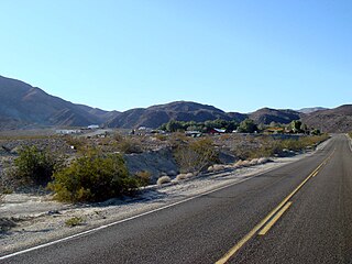
Panamint Springs is private resort in Inyo County, California. It consists of a motel, cabins, RV and tent campsites, restaurant, and gas station, all operated by Cassell Enterprises, LLC. It lies at an elevation of 1926 feet.
The Lytton First Nation, a First Nations band government, has its headquarters at Lytton in the Fraser Canyon region of the Canadian province of British Columbia. While it is the largest of all Nlaka'pamux bands, unlike all other governments of the Nlaka'pamux (Thompson) people, it is not a member of any of the three Nlaka'pamux tribal councils, which are the Nicola Tribal Association, the Fraser Canyon Indian Administration and the Nlaka'pamux Nation Tribal Council.
John Irving was a steamship captain in British Columbia, Canada. He began on the Fraser River at the age of 18 and would become one of the most famous and prosperous riverboat captains of the era. His father, William Irving, was known as the "King of the River" and the neighborhood of Irvington in Portland, Oregon, is named in honor of their family.
James William Troup was an American steamship captain, Canadian Pacific Railway administrator and shipping pioneer.

Siska, also known historically as Cisco, is a locality in the Fraser Canyon, 9.4 kilometres south of the town of Lytton, British Columbia, Canada. It is at Siska that the Canadian Pacific and Canadian National Railways switch from one side of the river to the other, because it is impossible for both rail lines to occupy the same bank of the Fraser, due to the narrow and steep terrain. The resulting pair of bridges, with the CNR bridge just upstream of the CPR's, and the CPR's bridge's west foot entering the Cantilever Bar Tunnel into the side of Cisco Bluff, remains one of the most famous images of the CPR's route through British Columbia today and is easily viewable from the adjacent Trans-Canada Highway.

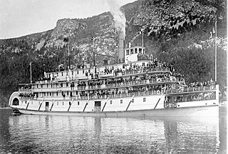
SS Sicamous is a large, four-decked sternwheeler commissioned by the Canadian Pacific Railway (CPR) and was built by the Western Dry Dock and Shipbuilding Company for Okanagan Lake service between the fruit communities of Penticton, and other towns of Kelowna and Vernon, British Columbia. The vessel launched in 1914 and operated until 1937, and it is currently beached as a part of a heritage park cared for by the S.S. Sicamous Marine Heritage Society in Penticton. The vessel today is operated both as a museum, restoration site, and a facility for special events.
The Bridge River Rapids, also known as the Six Mile Rapids, the Lower Fountain, the Bridge River Fishing Grounds, and in the St'at'imcets language as Sat' or Setl, is a set of rapids on the Fraser River, located in the central Fraser Canyon at the mouth of the Bridge River six miles north of the confluence of Cayoosh Creek with the Fraser and on the northern outskirts of the District of Lillooet, British Columbia, Canada.

Narrow Hills Provincial Park is a northern boreal forest provincial recreational park in the Canadian province of Saskatchewan. It is located in a hilly plateau called the Cub Hills and contains several recreational facilities and over 25 accessible lakes within its boundaries. The geographical features of the park, including the lakes, valleys, and lowlands were formed over 10,000 years ago during the last ice age. The town of Smeaton is the closest community and it is located 70 kilometres (43 mi) to the south.

Halcyon Hot Springs, also known simply as Halcyon, is a hot springs resort and spa on the east side of Upper Arrow Lake, between Galena Bay and Nakusp, in the West Kootenay region of British Columbia. Nearby to the northeast, Halcyon Mountain derives its name from the springs.

Yogi Bear's Jellystone Park Camp-Resorts is a chain of more than 75 family friendly campgrounds throughout the United States and Canada. The camp-resort locations are independently owned and operated and each is franchised through Camp Jellystone, LLC, a wholly owned subsidiary of Sun Communities. The current President of Camp Jellystone is Robert (Rob) Schutter, Jr.
Nasookin was a sternwheel-driven steamboat that operated on Kootenay Lake in British Columbia from 1913 to 1947. Nasookin was one of the largest inland steam vessels ever to operate in British Columbia and the Columbia River and its tributaries. Nasookin became surplus to its original owner, the Canadian Pacific Railway, and was transferred to the British Columbia Provincial government which used it as an auto ferry until 1947. Negligent mooring of the steamer in 1948 led to irreparable damage to its hull, and it was later scrapped. Portions of the upper works were salvaged and used as a house.
