Lancaster is a charter city in northern Los Angeles County, in the Antelope Valley of the western Mojave Desert in Southern California. As of the 2020 census, the population was 173,516, making Lancaster the 153rd largest city in the United States and the 30th largest in California. Lancaster is a twin city with its southern neighbor Palmdale; together, they are the principal cities within the Antelope Valley region.

Palmdale is a city in northern Los Angeles County in the U.S. state of California. The city lies in the Antelope Valley of Southern California. The San Gabriel Mountains separate Palmdale from the Los Angeles Basin to the south.

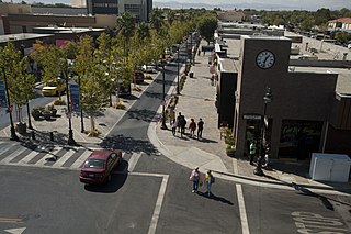
Quartz Hill is a census-designated place (CDP) in Los Angeles County, California, United States. The population was 10,912 at the 2010 census, up from 9,890 at the 2000 census. The name is also shared with the neighboring district areas of its border cities, Palmdale, and Lancaster. Quartz Hill was once home to the Quartz Hill Airport. According to the Greater Antelope Valley Economic Alliance report of 2009, the Palmdale / Lancaster urban area of which Quartz Hill is a part, has a population of 483,998.

Antelope Valley California Poppy Reserve is a state-protected reserve of California, United States, harboring the most consistent blooms of California poppies, the state flower. The reserve is located in the rural west side of Antelope Valley in northern Los Angeles County, 15 miles (24 km) west of Lancaster. To the north is Kern County. The reserve is at an elevation ranging from 2,600 to 3,000 feet above sea level, in the Mojave Desert climate zone. The reserve is administered by the California Department of Parks and Recreation. Other wildflowers within the reserve include the Owl's Clover, Lupine, Goldfields, Cream Cups and Coreopsis.

Arthur B. Ripley Desert Woodland State Park is a state park in the western Antelope Valley in Southern California. The park protects mature stands of Joshua trees and California juniper trees in their western Mojave Desert habitat.

The Antelope Valley is located in northern Los Angeles County, California, United States, and the southeast portion of California's Kern County, and constitutes the western tip of the Mojave Desert. It is situated between the Tehachapi, Sierra Pelona, and the San Gabriel Mountains. The valley was named for the pronghorns that roamed there until they were all eliminated in the 1880s, mostly by hunting, or resettled in other areas. The principal cities in the Antelope Valley are Palmdale and Lancaster.

State Route 14 is a north–south state highway in the U.S. state of California that connects Los Angeles to the northern Mojave Desert. The southern portion of the highway is signed as the Antelope Valley Freeway. The route connects Interstate 5 on the border of the city of Santa Clarita to the north and the Los Angeles neighborhoods of Granada Hills and Sylmar to the south, with U.S. Route 395 (US 395) near Inyokern. Legislatively, the route extends south of I-5 to SR 1 in the Pacific Palisades area of Los Angeles; however, the portion south of the junction with I-5 has not been constructed. The southern part of the constructed route is a busy commuter freeway serving and connecting the cities of Santa Clarita, Palmdale, and Lancaster to the rest of the Greater Los Angeles area. The northern portion, from Vincent to US 395, is legislatively named the Aerospace Highway, as the highway serves Edwards Air Force Base, once one of the primary landing strips for NASA's Space Shuttle, as well as the Naval Air Weapons Station China Lake that supports military aerospace research, development and testing. This section is rural, following the line between the hot Mojave desert and the forming Sierra Nevada mountain range. Most of SR 14 is loosely paralleled by a rail line originally built by the Southern Pacific Railroad, and was once the primary rail link between Los Angeles and Northern California. While no longer a primary rail line, the southern half of this line is now used for the Antelope Valley Line of the Metrolink commuter rail system.


The Los Angeles County Department of Public Works (LACDPW) is responsible for the construction and operation of Los Angeles County's roads, building safety, sewerage, and flood control. DPW also operates traffic signals and intelligent transportation systems, drinking water systems in certain communities, operates five airports, paratransit and fixed route public transport, administers various environment programs, issues various permits for activities in the public roadway, and has a Department Emergency Operations Center that works in conjunction with the County Emergency Operations Center operated by the Sheriff's Department. The department is headquartered at 900 South Fremont Avenue in Alhambra, California.

The Western Los Angeles County Council (WLACC) (#051) is one of five Boy Scouts of America councils in Los Angeles County, California. Headquartered in Van Nuys, the council services over 30,000 youth spanning six districts including the San Fernando Valley, Santa Clarita Valley, Antelope Valley, Malibu, and much of West Los Angeles.

Area code 661 is a telephone area code in the North American Numbering Plan for Southern California. The numbering plan area comprises the majority of Kern County, part of Ventura County, Los Angeles County, Santa Barbara County, and Tulare County. It was created in an area code split of area code 805 on February 13, 1999.

KTPI-FM is a commercial radio station licensed to Mojave, California and serving the Antelope Valley region of Southern California. It is owned by RZ Radio LLC and broadcasts a country music format. It carries several syndicated shows: The Big D and Bubba Show in morning drive time, Big Time with Whitney Allen evenings and After Midnite with Granger Smith overnight.

The Mojave Road, also known as Old Government Road, is a historic route and present day dirt road across what is now the Mojave National Preserve in the Mojave Desert in the United States. This rough road stretched 147 miles (237 km) from Beale's Crossing, to Fork of the Road location along the north bank of the Mojave River where the old Mojave Road split off from the route of the Old Spanish Trail/Mormon Road.

High Desert is a vernacular region with non-discrete boundaries covering areas of the western Mojave Desert in Southern California. The region encompasses various terrain with elevations generally between 2,000 and 4,000 ft above sea level, and is located just north of the San Gabriel, San Bernardino, and Little San Bernardino Mountains.
Rancho La Liebre was a 48,800-acre (197 km2) Mexican land grant in present-day Kern County, California and Los Angeles County, given in 1846 by Governor Pío Pico to José María Flores. Liebre means "Hare" in Spanish and the rancho was named as such because of the abundance of jack rabbits in the area.

Bell Creek is a 10-mile-long (16 km) tributary of the Los Angeles River, in the Simi Hills of Ventura County and the San Fernando Valley of Los Angeles County and City, in Southern California.

Fairmont Butte is a butte of volcanic origins in the Antelope Valley just west of the City of Lancaster, California in Los Angeles County. Summit elevation is 3,130 feet above sea level. Parts of Fairmont Butte are situated within the boundaries of Antelope Valley California Poppy Reserve.
Centennial, California is a proposed 12,323-acre (49.87 km2) master-planned community on Tejon Ranch in northwestern Los Angeles County between Bakersfield and Los Angeles. It is situated in the far western Antelope Valley at the foothills of the Sierra Pelona and Tehachapi Mountains. It would be built along California State Route 138 east of Interstate 5 and northeast of Quail Lake.
