The Krishna River in the Deccan plateau is the third-longest river in India, after the Ganga and Godavari. It is also the fourth-largest in terms of water inflows and river basin area in India, after the Ganges, Indus and Godavari. The river, also called Krishnaveni, is 1,400 kilometres (870 mi) long and its length in Maharashtra is 282 kilometres. It is a major source of irrigation in the Indian states of Maharashtra, Karnataka, Telangana and Andhra Pradesh.

The Kaveri is a major river flowing across Southern India. It is the third largest river in the region after Godavari and Krishna. The catchment area of the Kaveri basin is estimated to be 81,155 km2 (31,334 sq mi) and encompasses the states of Tamil Nadu, Karnataka, Kerala, and the union territory of Puducherry.

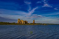
Krishna Raja Sagara, also popularly known as KRS, is a lake and the dam that creates it. They are close to the settlement of Krishna Raja Sagara in the Indian State of Karnataka. The gravity dam made of surki mortar is below the confluence of river Kaveri with its tributaries Hemavati and Lakshmana Tirtha, in the district of Mandya.

Bhakra Nangal Dam is a concrete gravity dam on the Satluj River in Bhakra Village in Bilaspur district, Himachal Pradesh in northern India. The dam forms the Gobind Sagar reservoir. Nangal Dam is another dam at Nangal in Punjab downstream of Bhakra Dam. However, sometimes both the dams together are called Bhakra-Nangal Dam though they are two separate dams.

The Kabini River (Kapila River) is one of the major tributaries of the river Cauvery in southern India, It originates near Kavilumpara in Kozhikode district of Kerala state by the confluence of the Panamaram River and the Mananthavady River. It flows eastward through Wayanad district, entering Mysore district of Karnataka, to join the Kaveri River in Mysore district of Karnataka.

The Mettur Dam is one of the largest dams in India and also the largest in Tamil Nadu, located across the river Kaveri where it enters the plains. Built in 1934, it took nine years to complete. Maximum height and width of the dam are 214 and 171 feet, respectively. The dam receives inflows from its own catchment area, Kabini Dam and Krishna Raja Sagara Dams located in Karnataka. There is a park at the base of the dam. It provides irrigation and drinking water facilities for more than 12 districts of Tamil Nadu and hence is revered as the life and livelihood-giving asset of Tamil Nadu.

Chikmagalur previously known as Kiriya-Muguli is a city and the headquarters of Chikmagalur district in the Indian state of Karnataka. Located on the foothills of the Mullayanagiri peak of the Western Ghats, the city attracts tourists from around the world for its pleasant and favourable hill station climate, tropical rainforest and coffee estates. The pristine Baba Budangiri lies to the north of Chikmagalur where it's believed Baba Budan first introduced coffee to India.

The Hemavati is a river in southern India's Karnataka and an important tributary of the Kaveri.
Krishnarajasagara is a town in Mandya district in the Indian state of Karnataka.

Sakleshpur, also known as Sakleshpura or Sakaleshapura, is a hill station town and headquarters of Sakleshpur taluk and one of the two Sub-divisional headquarters in Hassan district in the Indian state of Karnataka.

Karnataka, the sixth largest state in India, was ranked as the third most popular state in the country for tourism in 2014. It is home to 507 of the 3600 centrally protected monuments in India, second only to Uttar Pradesh. The State Directorate of Archaeology and Museums protects an additional 752 monuments and another 25,000 monuments are yet to receive protection.

The Indian State of Karnataka is located between 11°30' North and 18°30' North latitudes and between 74° East and 78°30' East longitude.It is situated on a tableland where the Western Ghats and Eastern Ghats converge into the complex, in the western part of the Deccan Peninsular region of India. The State is bounded by Maharashtra and Goa States in the north and northwest; by the Lakshadweep Sea in the west; by Kerala in the south-west and Tamil Nadu in the south and south-east, Andhra Pradesh in the south-east and east and Telangana in the north-east. Karnataka extends to about 850 km (530 mi) from north to south and about 450 km (280 mi) from east to west.
Tigra Dam creates a freshwater reservoir on the Sank River, about 23 km from Gwalior, Madhya Pradesh, India It plays a crucial role in supplying water to the city and is an important tourism spot of Gwalior.

The Bhadra Dam or Lakkavalli Dam, which has created the Bhadra Reservoir, is located on the Bhadra River a tributary of Tungabhadra River. Bhadra Dam is located in the border of Bhadravathi and Tarikere, in the western part of Karnataka in India. The benefits derived from the reservoir storage are irrigation with gross irrigation potential of 162,818 hectares, hydro power generation of 39.2 MW, drinking water supply and industrial use. The dam commissioned in 1965 is a composite earth cum masonry structure of 59.13 metres (194.0 ft) height with length of 1,708 metres (5,604 ft) at the crest level, which submerges a land area of 11,250.88 hectares.

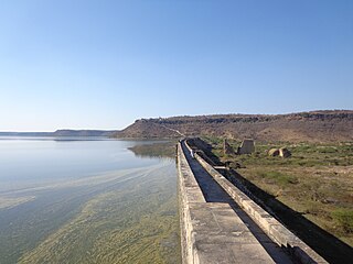
The Tungabhadra Dam, also known as Pampa Sagar, is a water reservoir constructed across the Tungabhadra River in the Hosapete-Koppal confluence in Karnataka, India. It is a multipurpose dam serving irrigation, electricity generation, flood control, etc. for the state. It is India's largest stone masonry dam and one of the only two non-cement dams in the country, the other being the Mullaperiyar Dam in Kerala. The dam is built of surki mortar, a combination of mud and limestone, commonly used at the time of its construction.

Hulikal is a village located in the Hosanagara taluk of the Shimoga district in the Indian state of Karnataka and is known for its heavy rainfall. The Hulikal village lies in the Western Ghat region of Karnataka state. The range of ghat is known by the name Hulikal ghat or Balebare ghat. The road running between Hosangadi and Mastikatte through Hulikal ghati connects the coastal district of Udupi with Shivamogga (Shimoga) district. The Mani dam reservoir and Savehoklu reservoir are nearby. KPCL has its colony at Mastikatte near to Hulikal. The nearest airport is at Mangalore, situated 123 km south-west of Hulikal. It has an elevation of 600m.

The Yagachi is a river in Karnataka, India. It is a major tributary of Hemavati river. It rises in the Baba Budan Hill Range near the city of Chikkamagaluru, flows through Belur taluk, Hassan District. It joins the Hemavati River, near Gorur. It has a small tributary called Votehole or Watehole. Votehole dam is built on the stream near Rajanahalli. The length of Left bank and Right bank canal of Votehole is 10 km & 40 km respectively.

Sagara is a city located in the Indian state of Karnataka. It is also a sub divisional and a taluk headquarters. Located in the Sahyadri Mountain range on the banks of river Varada, it is known for its proximity to Jog Falls and to the historical places of Ikkeri, Keladi and Varadamoola. The river Varada originates near Varada-moola. Sagara subdivision consists of Sagara, Soraba, Hosanagara and Shikaripur taluks.
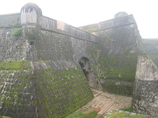
Manjarabad fort also pronounced as Manzrabad is a star fort built in 1792 by Tipu Sultan the then Sarvadhakari/ruling on behalf of Mysore King of Mysore following French star-shaped fort designs made popular by Sébastien Le Prestre de Vauban that deflect cannon fire and allow guns to cover all approaches without dead positions. It is in the Hassan district in the Indian state of Karnataka.
Gorur is a small village in Hassan district of Karnataka state in India.