Desh is a region of Maharashtra state in central India.
Satara district is a district of Maharashtra state in western India with an area of 10,480 km² and a population of 3,003,741 of which 14.17% were urban. Satara is the capital of the district and other major towns include Wai, Karad, ,Koregaon, Dahiwadi, Koynanagar, Rahimatpur, Phaltan, Mahabaleshwar, Vaduj and Panchgani. This district comes under Pune Administrative Division along with Pune, Sangli, Solapur and Kolhapur. The district of Pune bounds it to the north, Raigad bounds it to the North-West, Solapur the east, Sangli to the south, and Ratnagiri to the west.
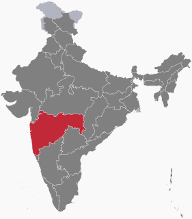
Sangli District is a district of Maharashtra State in west-central India. Sangli City is the district headquarters. The district is 25.11% urban. Sangli and Miraj are the largest cities. The industrial town of Kirloskarwadi is also located in the Sangli District. Industrialist Laxmanrao Kirloskar started his first factory here. It is known as the sugar bowl of India due to its high sugarcane productivity. Sangli District is one of the most fertile and highly developed districts in Maharashtra. The District is very popular as a political power house in the state. Sangli District has provided many popular politicians and bureaucrats until now. Sangli has a rich history and cultural heritage. People often refers to Sangli District as the Heaven of Farmers.

Sangli-Miraj & Kupwad is a city and a municipal corporation in Sangli district in the Indian state of Maharashtra.
Tasgaonpronunciation (help·info) is a city and a municipal council in Sangli district in the Indian state of Maharashtra. Tasgaon was given as Jahagir to Parshuram Bhau Patwardhan by Narayan Ballal Peshava in 1774. Tasgaon sansthan was lapsed by British during ruling of Shrimant Ganapatrao Patwardhan.Tasgaon Grapes from the city from Tasgaon are very famous grapes in Maharashtra. Tasgaon has rapidly merged with Sangli city as a satellite suburb and will soon become part of Sangali Urban Agglomeration.

Chandoli National Park is natural World Heritage Site and 317.67 km2 (122.65 sq mi) National Park spread overSatara, Kolhapur and Sangli District, Maharashtra State, India, established in May 2004. Earlier it was a Wildlife Sanctuary declared in 1985. Chandoli Park is notable as the southern portion of the Sahyadri Tiger Reserve, with Koyna Wildlife Sanctuary forming the northern part of the reserve
Ashta is a town and a municipal council in Sangli district in the state of Maharashtra, India. It is located at 16.95°N 74.4°E. It has an average elevation of 567 metres (1860 ft). The name "Ashta" comes from the legend that Lord Shri Ram established eight (Asht) Lord Mahadev temples in this area. The city is divided into 19 wards for which elections are held every 5 years. The Ashta Municipal Council has the population of 37,105 of which 19,171 are males while 17,934 are females as per the report released by Census India 2011.

Mangasuli is a village located in Northern Karnataka, India. It is located in the Athani taluk of Belgaum district in Karnataka. It has both Marathi and Kannada speaking people.
Prachitgad is a fort in the Sahyadri mountain range in Maharashtra state, India. It covers an area of 5 acres (20,000 m2).

Karajagi is a village in jath, in the state of Maharashtra]], India. It is located in the [jath]] taluk of sangli district.
V. T. Patil was an education reformer and politician who represented Kolhapur as a Member of Parliament in the 3rd Lok Sabha that sat between 1962 and 1967. His interest in development of education in Kolhapur — a town in Maharashtra, India — is reflected in the various institutions that he either founded or was involved in founding.
Walwa is a tehsil/taluka in Walwa subdivision of Sangli district in the Indian state of Maharashtra. It is also known as Valva-Islampur Taluka. There are ninety-five panchayat villages in Walwa Taluka.
Diggewadi (Kannada:ಡಿಜಿಗೇವಾಡಿ) is a village in Raybag taluk in Belgaum Panchayat in the southern state of Karnataka, India. The official language of Diggewadi is Kannada.

Sangli State was one of the 11-gun salute Maratha princely states of British India. It was under the Kolhapur-Dekkan Residency in the Bombay Presidency, and later the Deccan States Agency.
Bhood is a village in Khanapur tehsil of Sangli district in Maharashtra, India. It is located near the city Vita.
Arag is a small town in Sangli district in the Indian state of Maharashtra. It is approximately 30 km south east of the much larger urban conglomeration of Sangli-Miraj.
Wangi is a village in Kadegaon taluka, Sangli district, Maharashtra, India. The population was 9,895 at the 2011 Indian census.
Sangli railway station is a railway station serving Sangli city in Maharashtra State of India. It is class A station under Pune railway division of Central Railway Zone of Indian Railways.
Earndoli is a village in Miraj Taluka in Sangli District of Maharashtra State, India. It belongs to Desh or Paschim Maharashtra region. It is in Pune Division. It is located 9 km East from the district headquarters Sangli and 361 km from State capital Mumbai
Peth Islampur is a village in the Sangli district of India, with a population of 11,238 as of 2011.