Related Research Articles
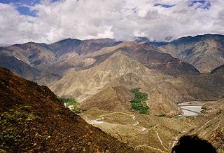
The Marañón River is the principal or mainstem source of the Amazon River, arising about 160 km to the northeast of Lima, Peru, and flowing through a deeply eroded Andean valley in a northwesterly direction, along the eastern base of the Cordillera of the Andes, as far as 5° 36′ southern latitude; from where it makes a great bend to the northeast, and cuts through the jungle Andes, until at the Pongo de Manseriche it flows into the flat Amazon basin. Although historically, the term "Marañon River" often was applied to the river all the way to the Atlantic Ocean, nowadays the Marañon River is generally thought to end at the confluence with the Ucayali River, after which most cartographers label the ensuing waterway the Amazon River.

Peru is a country on the central western coast of South America facing the Pacific Ocean. It lies wholly in the Southern Hemisphere, its northernmost extreme reaching to 1.8 minutes of latitude or about 3.3 kilometres (2.1 mi) south of the equator. Peru shares land borders with Ecuador, Colombia, Brazil, Bolivia, and Chile, with its longest land border shared with Brazil.

Moyobamba or Muyupampa is the capital city of the San Martín Region in northern Peru. Called "Santiago of eight valleys of Moyobamba" or "Maynas capital". There are 50,073 inhabitants, according to the 2017 census. Some 3,500 species of orchids are native to the area, which has led to the city's nickname of The City of Orchids. The city is the capital of both Moyobamba Province and Moyobamba District.

Huacho is a city in Peru, capital of the Huaura Province and capital of the Lima Region. Also is the most populated city of the Lima Region and Norte Chico. It is located 223 feet above sea level and 148 km north of the city of Lima. The city is located on the Pan-American Highway and it is close to the Lachay National Reserve, so it has extensive vegetation and wildlife.

Callao is one of the seven districts of the Constitutional Province of Callao in the Callao Region, Peru. The Chillón River marks the district's northern border with Ventanilla. On the east, the Callao district is bordered by the Carmen de la Legua-Reynoso as well as the Lima Province's districts of San Martín de Porres and Lima. The Bellavista and the La Perla districts are located to the southeast, while La Punta borders the district on the west. The Pacific Ocean borders the province on the west and south. At 1956, it expanded to the north, encompassing latifunds, lands and estates that belonged to the San Martín de Porres District and the Carabayllo district. During this expansion, the Jorge Chávez International Airport is built.

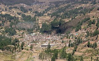
Chachapoyas is a city in northern Peru at an elevation of 2,335 meters (7,661 ft). The city has a population of 32,026 people (2017). Situated in the mountains far from the Peruvian coast, Chachapoyas remains fairly isolated from other regions of Peru. It is served by buses to Chiclayo and Cajamarca, and flights to domestic locations from Chachapoyas Airport.
Rioja is the capital of Rioja Province in the San Martín Region in northern Peru. It is situated to the west of Moyobamba. There are 24,263 inhabitants according to the 2007 census.

Independencia is a district of the Lima Province in Peru. It is located in the north area of the city.

Baltasar de la Cueva y Enríquez de Cabrera,iure uxorisCount of Castellar and Marquis of Malagón was viceroy of Peru from August 15, 1674 to July 7, 1678.

Quinuabamba District is one of 4 districts in the Pomabamba Province of the Ancash Region in Peru.
Huari is one of the 16 districts that integrates the Peruvian Huari Province in the Ancash region. The district consists of the city of Huari, 15 small villages and 22 annexes.
Copa District is one of five districts of the province Cajatambo in Peru.
San Miguel de Acos District is one of twelve districts of the province Huaral in Peru.
Huachis District is one of sixteen districts of the Huari Province in the Ancash Region in Peru.

Purple corn or purple maize is group of flint maize varieties originating in South America, descended from a common ancestral variety termed "k'culli" in Quechua. It is most commonly grown in the Andes of Peru, Bolivia and Ecuador.
Chancay is a small city located 78 km (48 mi) north of Lima. Its population is 63,378. The Chancay culture was a pre-Columbian archaeological culture, later part of the Inca Empire.

Christian Alberto Cueva Bravo is a Peruvian professional footballer who plays as an attacking midfielder for Saudi Arabian club Al-Fateh and the Peru national team.
Castillo de Gorioj o Tucumachay is an archaeological site in Peru. It is situated in the Huánuco Region, Huamalíes Province, Miraflores District, at a height of about 3,696 metres (12,126 ft).

Purunllacta or Purum Llacta (possibly from Quechua purum, purun savage, wild / wasteland, llaqta place is an archaeological site in Peru. It is situated in the Amazonas Region, Chachapoyas Province, Soloco District, southwest and near the archaeological site of Purum Llaqta of the Cheto District.

Sara Sara is a 5,505-metre-high (18,061 ft) volcano lying between Lake Parinacochas and the Ocoña River in Peru. It is situated in the Parinacochas Province and the Paucar del Sara Sara Province. The volcano formed during the Pleistocene during four different stages of volcanic activity, which constructed a volcanic edifice with an oval outline consisting of lava flows and lava domes. The volcano was glaciated during the last glacial maximum; it may still feature glaciers. The last eruption was about 14,000 years ago and future eruptions are possible. The volcano was worshipped by the local population, and an Inca mummy of a 15-year old girl was found on the summit by archaeologists.
References
- ↑ "Shihual (Cueva de) Archivos". Cuevas y Tragaderos de Perú y Bolivia (in Spanish). Retrieved 2022-11-22.
- ↑ Revilla Bueloth, Maritza (20 December 2012). "Evaluación de los recursos turísticos del distrito de Magdalena, Chachapoyas, Región Amazonas, Perú". Ciencia y Tecnología. 8.
Coordinates: 6°22′19″S77°52′54″W / 6.3720°S 77.8818°W
| | This Amazonas Region geography article is a stub. You can help Wikipedia by expanding it. |