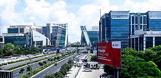
Gurgaon, officially Gurugram, is a city located in the northern Indian state of Haryana. It is situated near the Delhi-Haryana border, about 30 kilometres (19 mi) southwest of the national capital New Delhi and 268 km (167 mi) south of Chandigarh, the state capital. It is one of the major satellite cities of Delhi and is part of the National Capital Region of India. As of 2011, Gurgaon had a population of 876,900.

Najafgarh is a town in the South West Delhi district in the National Capital Territory of Delhi, India. It is one of the three subdivisions of the Southwest Delhi district. Najafgarh is located at the outskirts of the southwestern part of Delhi near the Haryana border, a distance of 29 kilometres from the New Delhi City Center. It has a mixture of rural and urban populations from Delhi and Haryana. Due to the presence of much freehold land, Najafgarh is one of the fastest-developing tehsils (sub-districts) in southwestern Delhi.

Sultanpur National Park is located at Sultanpur village on Gurugram-Jhajjar highway, 15 km from Gurugram, Haryana and 50 km from Delhi in India. This covers approximately 142.52 hectares.

Bahadurgarh, known as the "Gateway of Haryana" " is a Subdistrict,and a municipal council located in Jhajjar, a district in the state of Haryana, India, which comprises 31 wards. Bahadurgarh is approximately 2 km from Delhi. It is one of the major cities of Haryana and is surrounded by major NCR cities(Faridabad, Gurugram & Sonipat)
Ghitorni is a village in the South West district in the state of Delhi, India. It is located in southern Delhi, near the Gurgaon border and Vasant Kunj. In the 2011 census the population was 14,893. The population consists mainly of Gujjars (80%), as well as the Brahmans (10%), Scheduled Castes (5%), Aggarwals and others (5%) (estimated).It comes between Aya Nagar and Sultanpur

Jona Pur is a census town in South district in the Indian state of Delhi.
Sohna is a town and a municipal committee in the Gurgaon district of Haryana, India. A popular tourist weekend and conference retreat, it is on the highway from Gurgaon to Alwar near a vertical rock. Sohna is known for its hot springs and Shiva temple. Sohna tehsil is part of Ahirwal Region. Major communities in Sohna are Ahirs, Gujars, Jats, Thakurs and Muslims.

Lonipronunciation (help·info) is a town in Ghaziabad district in Uttar Pradesh state, National Capital Region of India and Loni city is governed by Municipal Corporation which comes under Ghaziabad Metropolitan Region.
Narela sub-city is a tehsil, located in the North Delhi district of NCT of Delhi, and forms the border of the Delhi state with Haryana. Situated just off the Grand Trunk Road, its location made it an important market town for the surrounding areas, during the 19th century, which it still retains. It was developed as the third mega sub-city project of Delhi Development Authority (DDA) in the urban extension project of Delhi, after Rohini Sub City and Dwarka Sub City. and covering an area of 9866 ha. The 'Narela Industrial Area', started developing in the early 1980s and is today one of the important such complexes in Delhi.

The Najafgarh drain or Najafgarh nalah, which also acts as Najafgarh drain bird sanctuary, is another name for the northernmost end of River Sahibi, which continues its flow through Delhi, where it is channelized, and then flows into the Yamuna. Within Delhi, due to its channelization for flood control purposes, it is now erroneously called "Najafgarh drain" or "Najafgarh nullah." It gets this name from the once famous and huge Najafgarh Jheel (lake) near the town of Najafgarh in southwest Delhi and within urbanized Delhi. It is the Indian capital’s most polluted water body due to direct inflow of untreated sewage from surrounding populated areas. A January 2005 report by the Central Pollution Control Board classifies this drain, with 13 other highly polluted wetlands, under category ‘‘D’’ for assessing the water quality of wetlands in wildlife habitats.
Najafgarh Lake, Najafgarh Marsh or Najafgarh Jheel, fed by Sahibi River, used to be a vast lake in the south west of Delhi in India near the town of Najafgarh from which it takes its name. It was connected to the river Yamuna by a natural shallow nullah or drain called the Najafgarh nullah. However, after the 1960s the Flood Control Department of Delhi kept widening the Najafgarh drain in the pretext of saving Delhi from floods and eventually quickly drained the once huge and ecologically rich Najafgarh lake completely. Rainwater accumulating in the Najafgarh lake or jheel basin had been recorded to have occupied more than 300 square kilometres (120 sq mi) in many years before its unfortunate draining.
Najafgarh drain bird sanctuary(proposed)and wetland ecosystem is composed of the wetland ecosystem and wildlife habitat on several kilometres of the Najafgarh drain or nullah which passes through rural southwest Delhi in India's capital territory. It includes the portion draining the depression or basin area that formed the once famous but now completely drained Najafgarh lake or Najafgarh jheel.

Shiv Ram Park is a residential area situated on Najafgarh Road in West Delhi area of Nangloi. It is about 2.5 km away from Nangloi Metro Station. There is a famous locality known as Kamruddin Nagar or Kamruddin village located nearby. Nearby Shiv Ram Park there are some other famous areas we can find Like Kunwar Singh Nagar, Adhyapak Nagar, Lakshmi Park, Nihal Vihar, Nilothi More, Rishal Garden etc.
Chhawla or Najafgarh drain city forest consists of forestry plantations near the town of Chhawla on both embankments of Najafgarh drain, which is the delhi-end of Sahibi River originating from Aravalli range mountain in Rajasthan, flowing along the border of Haryana state and south west Delhi in India before confluencing with Yamuna. It provides refuge to local and migratory wildlife specially waterfowl and other water birds. The area is a subset of the entire Najafgarh drain in rural south west Delhi with forested plantations on both its embankments which has been proposed as the Najafgarh drain bird sanctuary.
Bhalswa Horseshoe Lake, or Bhalswa Jheel, is a lake in northwest Delhi, India. It was originally shaped like a horseshoe. However, over the years half of it was used as a landfill area. Now a low income housing colony, an extension of the nearby town of Bhalswa Jahangir Puri has been built on it, destroying the once excellent wetland ecosystem and wildlife habitat of the region which once played host to scores of local and migratory wildlife species, especially waterbirds, including waterfowl, storks and cranes. This horseshoe lake was originally formed when the nearby River Yamuna left behind one of its meandering loops here when it changed course over the years and is now channelled through more defined and fortified embankments and dykes to defend modern Delhi from floods.
The Sahibi river, also called the Sabi River, is an ephemeral, rain-fed river flowing through Rajasthan, Haryana and Delhi states in India. It drains into Yamuna in Delhi, where its channeled course is also called the Najafgarh drain, which also serves as Najafgarh drain bird sanctuary. Sahibi is a seasonal river which is 300 km long and flows from Aravalli hills in Rajasthan to Haryana, of which 100 km is in Haryana.

Chanch is a village in Molekhal tehsil of Almora district in the Indian state of Uttarakhand. Chanch is at 16.7 km distance from tehsil Molekhal, which too is small market. It is 180.8 km distant from its district main city Almora.
Bhindawas Wildlife Sanctuary is located in Jhajjar district, which is about 15 km from Jhajjar town. On 3rd June 2009, it is also declared as bird sanctuary by Indian Government.
Ujina is a Village located in Hodal-Nuh road in Nuh district in Haryana. In Ancient time, Ujina was popular with the name of Ujina Lake as in rainy season it totally covered with water and people of nearby territories often came here for sightseeing. Ujina has 100% Hindu population. The People of Ujina actively participated in every war of Independence of India, whether it was the 1857 war; The First war of Independence or the Satyagrah by Mahatma Gandhi.

Karui is a village in Katwa II CD block in Katwa subdivision of Purba Bardhaman district of West Bengal state in East India. The meaning of Karui is Grain Storage.