
Narita is a city in Chiba Prefecture, Japan. As of 30 November 2020, the city had an estimated population of 131,852 in 63,098 households and a population density of 620 persons per km². The total area of the city is 213.84 square kilometres (82.56 sq mi). It is the site of Narita International Airport, one of the two main international airports serving the Greater Tokyo Area.

Kashiwa is a city located in Chiba Prefecture, Japan. As of May 1, 2024, the city had an estimated population of 435,578 in 199,926 households and a population density of 3800 persons per km2. The total area of the city is 114.72 square kilometres (44.29 sq mi).

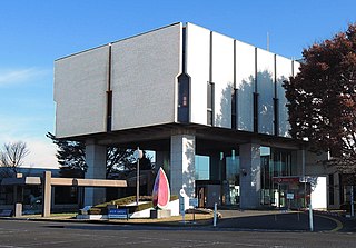
Kamagaya is a city located in Chiba Prefecture, Japan. As of 1 December 2020, the city had an estimated population of 109,941 living in 50,485 households and a population density of 5,200 persons per km2. The total area of the city is 21.08 km2 (8.14 sq mi).
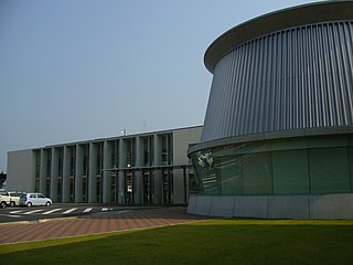
Tomisato is a city located in Chiba Prefecture, Japan. As of 1 November 2020, the city had an estimated population of 49,914 in 23,753 households and a population density of 930 persons per km2. The total area of the city is 53.91 square kilometres (20.81 sq mi).

Sakura is a city located in Chiba Prefecture, Japan. As of 1 November 2020, the city had an estimated population of 173,740 in 78,483 households and a population density of 1700 people per km2. The total area of the city is 103.59 square kilometres (40.00 sq mi).

Shimōsa Province was a province of Japan in the area of modern Chiba Prefecture and Ibaraki Prefecture as well as the bordering parts of Saitama Prefecture and Tokyo. It lies to the north of the Bōsō Peninsula (房総半島), whose name takes its first kanji from the name of Awa Province and its second from Kazusa and Shimōsa Provinces. Its abbreviated form name was Sōshū (総州) or Hokusō (北総).

Shisui is a town located in Chiba Prefecture, Japan.As of 1 December 2020, the town had an estimated population of 20,660 in 9,888 households and a population density of 1,100 persons per km2. The total area of the town is 19.02 square kilometres (7.34 sq mi).

Shimofusa was a town located in Katori District, Chiba Prefecture, Japan.
Tako is a town located in Chiba Prefecture, Japan. As of 1 December 2020, the town had an estimated population of 14,387 in 6068 households and a population density of 200 persons per km². The total area of the town is 72.68 square kilometres (28.06 sq mi).
Tōnoshō is a town located in Chiba Prefecture, Japan. As of 1 December 2020, the town had an estimated population of 13,637 in 5234 households and a population density of 300 persons per km². The total area of the town is 46.16 square kilometres (17.82 sq mi).
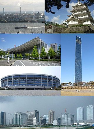
Chiba is the capital city of Chiba Prefecture, Japan. It sits about 40 kilometres (25 mi) east of the centre of Tokyo on Tokyo Bay. The city became a government-designated city in 1992. In June 2019, its population was 979,768, with a population density of 3,605 people per km2. The city has an area of 271.77 square kilometres (104.93 sq mi).

Sakura Domain was a feudal domain under the Tokugawa shogunate of Edo period Japan, located in Shimōsa Province, Japan. It was centered on Sakura Castle in what is now the city of Sakura, Chiba. It was ruled for most of its history by the Hotta clan.

Tateyama Domain was a feudal domain under the Tokugawa shogunate of Edo period Japan, located in Awa Province, Japan. It was centered on Tateyama Castle in what is now the city of Tateyama, Chiba.
Omigawa Domain was a minor feudal domain under the Tokugawa shogunate of Edo period Japan, located in Shimōsa Province, Japan. It was centered on what is now part of the city of Katori. It was ruled for most of its history by the Uchida clan.
Tako Domain was a minor feudal domain under the Tokugawa shogunate of Edo-period Japan, located in Shimōsa Province (the northern portion of Chiba Prefecture Japan. It was centered on what is now part of the town of Tako in Katori District. It was ruled for most of its history by the Matsudaira clan.

The Shimōsa Plateau is a plateau on the Kantō Plain in central Honshu, Japan. The plateau covers most of northern Chiba Prefecture. The plateau was historically richly agricultural, but in the 20th century the western and central Shimōsa Plateau became one of the major industrial areas of Japan, as well as a large-scale bedroom community of the Tokyo Metropolitan Region. Narita International Airport is located in the center of the Shimōsa Plateau.

Sakura Castle was a 17th-century castle, now in ruins, in Sakura, Chiba Prefecture. It was designated one of Japan's Top 100 Castles by the Japanese Castle Foundation.
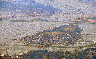
Moto Sakura Castle was a Muromachi period "hirayama"-style castle located on the border of the town of Shisui and the city of Sakura, Chiba Prefecture, Japan. Its ruins been protected as a National Historic Site since 1998.
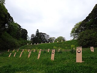
The Shimōsa Kogane Nakano ranch was a government-operated horse ranch during he Edo Period of Japan, which operated to supply cavalry mounts for the Tokugawa shogunate. It was located in what is now part of the city of Kamagaya, Chiba Prefecture in the Kantō region of Japan. The location was designated a National Historic Site of Japan in 2007.


