Shinmachi

Last updated

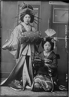
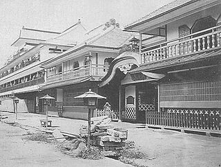
Shinmachi (新町) was a yūkaku (遊廓、遊郭, pleasure quarter, courtesan's district) in Osaka, built between 1615 and 1623, and operating until its destruction in World War II. It was situated roughly two kilometers southwest of Nakanoshima. Today, it is mostly a tourist attraction and historical site.

<i>Yūkaku</i>

Yūkaku (遊廓) meant the regions in Japan where brothels recognized by the government were situated. In theory, prostitution was legal only in the Yūkaku region, but there were some places where prostitution was provided illegally.

Osaka Designated city in Kansai, Japan

Osaka is a designated city in the Kansai region of Japan. It is the capital city of Osaka Prefecture and the largest component of the Keihanshin Metropolitan Area, the second largest metropolitan area in Japan and among the largest in the world with over 19 million inhabitants. Osaka will host Expo 2025. The current mayor of Osaka is Hirohumi Yoshimura.

Nakanoshima Sandbank in Osaka, Japan

Nakanoshima (中之島) is a 3 km long and 50 hectares narrow sandbank in Kita-ku, Osaka city, Japan, that divides the Kyū-Yodo River into the Tosabori and Dōjima rivers. Many governmental and commercial offices, museums and other cultural facilities are located on Nakanoshima.

Throughout the Edo period (1603–1868), there was widespread male and female prostitution throughout the cities of Kyoto, Edo, and Osaka. The Tokugawa shogunate attempted to control this by restricting prostitution to designated city districts, known as yūkaku. These districts were Shimabara in Kyōto (est. 1640 [1] ), Shinmachi in Osaka (est. 1624–1644 [1] ) and Yoshiwara in Edo (est. 1617 [1] ). These restrictions and controls did not derive from a moral opposition to prostitution, but out of a desire to compartmentalize certain types of activity within the cities. Kabuki and jōruri theatres, and other related entertainment establishments were similarly controlled.

Edo period period of Japanese history

The Edo period or Tokugawa period (徳川時代) is the period between 1603 and 1868 in the history of Japan, when Japanese society was under the rule of the Tokugawa shogunate and the country's 300 regional daimyō. The period was characterized by economic growth, strict social order, isolationist foreign policies, a stable population, "no more wars", and popular enjoyment of arts and culture. The shogunate was officially established in Edo on March 24, 1603, by Tokugawa Ieyasu. The period came to an end with the Meiji Restoration on May 3, 1868, after the fall of Edo.

Tokugawa shogunate last feudal Japanese military government which existed between 1600 and 1868

The Tokugawa Shogunate, also known as the Tokugawa Bakufu (徳川幕府) and the Edo Bakufu (江戸幕府), was the last feudal Japanese military government, which existed between 1603 and 1867. The head of government was the shōgun, and each was a member of the Tokugawa clan. The Tokugawa shogunate ruled from Edo Castle and the years of the shogunate became known as the Edo period. This time is also called the Tokugawa period or pre-modern.

Shimabara, Kyoto

Shimabara was the designated courtesans' district (yūkaku) in Kyoto, from 1640, and later also a geisha district (hanamachi). It is now defunct, both as a courtesans' district and as a geisha district, and thus is often excluded from the list of Kyoto hanamachi. It continues to operate as a tourist area, however, and does have one operating ochaya.

Related Research Articles

Kansai region Region

The Kansai region or the Kinki region lies in the southern-central region of Japan's main island Honshū. The region includes the prefectures of Mie, Nara, Wakayama, Kyoto, Osaka, Hyōgo and Shiga, sometimes Fukui, Tokushima and Tottori. While the use of the terms "Kansai" and "Kinki" have changed over history, in most modern contexts the use of the two terms is interchangeable. The urban region of Osaka, Kobe, and Kyoto is the second-most populated in Japan after the Greater Tokyo Area.

Yoshiwara red-light district of Edo

Yoshiwara (吉原) was a famous yūkaku in Edo, present-day Tōkyō, Japan.

Arashiyama human settlement in Japan

Arashiyama is a district on the western outskirts of Kyoto, Japan. It also refers to the mountain across the Ōi River, which forms a backdrop to the district. Arashiyama is a nationally designated Historic Site and Place of Scenic Beauty.

Dōtonbori Area in Osaka, Japan

Dōtonbori or Dōtombori is one of the principal tourist destinations in Osaka, Japan, running along the Dōtonbori canal from Dōtonboribashi Bridge to Nipponbashi Bridge in the Namba district of the city's Chuo ward. Historically a theater district, it is now a popular nightlife and entertainment area characterized by its eccentric atmosphere and large illuminated signboards.

Hanamachi (花街) is a Japanese geisha district. The word's literal meaning is "flower town". Such districts contain various okiya and ochaya (teahouses).

Yodo River river in Japan

The Yodo River, also called the Seta River and the Uji River at portions of its route, is the principal river in Osaka Prefecture on Honshū, Japan. The source of the river is Lake Biwa in Shiga Prefecture to the north.

Prostitution in Japan

Prostitution in Japan has existed throughout the country's history. While the Anti-Prostitution Law of 1956 states that "No person may either do prostitution or become the customer of it", loopholes, liberal interpretations and loose enforcement of the law have allowed the sex industry to prosper and earn an estimated 2.3 trillion yen per year.

<i>Oiran</i> high-ranking courtesan in Japan, whose occupation arose in the Edo period and was largely replaced by geisha by the late 19th century

Oiran (花魁) were courtesans in Japan. The oiran were considered a type of yūjo (遊女) "woman of pleasure" or prostitute. However, they are distinguished from ordinary yūjo in that they were entertainers, and many became celebrities even outside the pleasure districts. Their art and fashions often set trends and, because of this, cultural aspects of oiran traditions continue to be preserved to this day.

Fukushima-ku, Osaka ward of Japan

Fukushima-ku (福島区) is one of 24 wards of Osaka city in Japan. The ward is primarily a residential quarter, but has some office buildings and a commercial district, as well as factories and wholesale businesses. In recent years, many high rise apartment buildings and office buildings have been built in this ward, because it is close to the Umeda and Dōjima business centres.

Katsura River river in Japan

The Katsura River is a continuation of two other rivers, the Hozu River, a small, speedy river which begins in the mountains near Kameoka and then slithers through the mountains separating Kameoka and Kyoto; and the Ōi River, which emerges from those mountains and expands into a shallow, slow-flowing river until Togetsukyo Bridge in Arashiyama. From that point forward, the river is referred to as the Katsura River, and its flow continues for several kilometers through Osaka Prefecture until it joins the Kamo and Uji rivers.

Kamigata (上方) is a region of Japan referring to the cities of Kyoto and Osaka; the term is used particularly when discussing elements of Edo period urban culture such as ukiyo-e and kabuki, and when making a comparison to the urban culture of the Edo/Tokyo region.

69 Stations of the Nakasendō

The 69 Stations of the Nakasendō are the rest areas along the Nakasendō, which ran from Nihonbashi in Edo to Sanjō Ōhashi in Kyoto. The route stretched approximately 534 km (332 mi) and was an alternate trade route to the Tōkaidō.

53 Stations of the Tōkaidō Wikimedia list article

The 53 Stations of the Tōkaidō are the rest areas along the Tōkaidō, which was a coastal route that ran from Nihonbashi in Edo to Sanjō Ōhashi in Kyoto.

Honjō-shuku

Honjō-shuku was the tenth of the sixty-nine stations of the Nakasendō highway connecting Edo with Kyoto during the Edo period. It was the largest of the stations in terms of population and number of buildings. It was located in the present-day city of Honjō, Saitama Prefecture, Japan.

Kuragano-shuku

Kuragano-shuku was the twelfth of the sixty-nine stations of the Nakasendō. It is located in the present-day city of Takasaki, Gunma Prefecture, Japan.

Kammaki Station railway station in Takatsuki, Osaka prefecture, Japan

Kammaki Station is a railway station on the Hankyu Kyoto Line in Takatsuki, Osaka Prefecture, Japan, operated by the private railway operator Hankyu Railway. It is numbered "HK73".

Minase Station railway station in Shimamoto, Mishima district, Osaka prefecture, Japan

Minase Station is a train station on the Hankyu Railway Kyoto Line located in Shimamoto, Mishima District, Osaka Prefecture, Japan, along the Tōkaidō Shinkansen between Kyōto and Shin-Ōsaka Stations.

Zeze Station railway station in Otsu, Shiga prefecture, Japan

Zeze Station is a railway station in Ōtsu, Shiga, Japan. The station is on the Biwako Line of West Japan Railway Company. In front of Zeze Station is Keihan Zeze Station on the Ishiyama-Sakamoto Line of Keihan Electric Railway. This article covers both stations.

Kiyamachi Street street in Kyoto, Japan

Kiyamachi Street is a historical street in Kyoto, Japan, running north–south. It runs between Kiyamachi Nijō and Kiyamachi Shichijō on the eastern side of the Takase River near the Kamo River. There also runs Nishi-Kiyamachi Street on the western side of Takase River between Sanjō and Shichijō. It was constructed with the excavation of Takase River in the Edo period. Kiya is an old Japanese word which means woods stores. In 1895 a tram started to run between Kiyamachi Nijō and Kiyamachi Gojō. The tram line was moved to Kawaramachi Street in 1920s.

References

  1. 1 2 3 Anne Louise Avery, Flowers of the Floating World: Geisha and Courtesans in Japanese Prints and Photographs, 1772–1926 (Sanders of Oxford Exhibition Catalogue, March 2006)

34°40′39″N135°29′52″E / 34.6776°N 135.497805°E / 34.6776; 135.497805 Coordinates: 34°40′39″N135°29′52″E / 34.6776°N 135.497805°E / 34.6776; 135.497805 (Ruin of Shinmachi Bridge:East Gate)

Geographic coordinate system Coordinate system

A geographic coordinate system is a coordinate system that enables every location on Earth to be specified by a set of numbers, letters or symbols. The coordinates are often chosen such that one of the numbers represents a vertical position and two or three of the numbers represent a horizontal position; alternatively, a geographic position may be expressed in a combined three-dimensional Cartesian vector. A common choice of coordinates is latitude, longitude and elevation. To specify a location on a plane requires a map projection.