Guiseley is a town in metropolitan borough of the City of Leeds, West Yorkshire, England. Historically part of the West Riding of Yorkshire, it is situated south of Otley and Menston and is now a north-western suburb of Leeds.

Otley is a market town and civil parish at a bridging point on the River Wharfe, in the City of Leeds metropolitan borough in West Yorkshire, England. Historically a part of the West Riding of Yorkshire, the population was 13,668 at the 2011 census. It is in two parts: south of the river is the historic town of Otley and to the north is Newall, which was formerly a separate township. The town is in lower Wharfedale on the A660 road which connects it to Leeds.
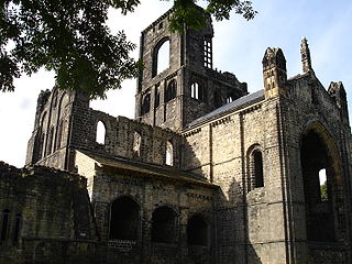
Kirkstall is a north-western suburb of Leeds, West Yorkshire, England, on the eastern side of the River Aire.

Yeadon is a town within the metropolitan borough of the City of Leeds, West Yorkshire, England.

Headingley is a suburb of Leeds, West Yorkshire, England, approximately two miles out of the city centre, to the north west along the A660 road. Headingley is the location of the Beckett Park campus of Leeds Beckett University and Headingley Stadium.

West Park is a suburb of north-west Leeds, West Yorkshire, England, north of Headingley. It is a mixed area of private suburban housing and suburban council estates. The name derives from its main park containing playing fields together with a conservation area of grassy meadow ending in woodland. The largest housing estate in West Park is Moor Grange.

Ireland Wood is a small residential area in north-west Leeds, West Yorkshire, England named after the Woodland Trust wood which it contains. It is approximately 4 miles (6.4 km) to the north-west of Leeds city centre. It was planned by Leeds Housing Director RAH Livett and won the Ministry Housing medal for 1945-9. An early plan of Ireland Wood in 1950 is shown on the Leodis website.

Holt Park is a medium-sized low-rise 1970s housing estate in the northwest suburbs of Leeds, West Yorkshire, England. It is approximately 6 miles (10 km) from Leeds city centre situated between Tinshill, Cookridge and Adel, and is at the edge of the Leeds urban fringe, bordering the green belt which makes up two thirds of the metropolitan borough of the City of Leeds. The nearby Tinshill BT Tower dominates the skyline.

Bramhope is a village and civil parish in the City of Leeds metropolitan borough, West Yorkshire, England, north of Holt Park and north east of Cookridge.
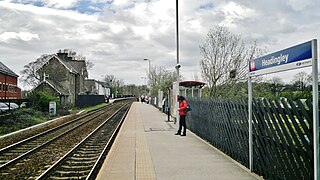
Headingley railway station is off Kirkstall Lane in Leeds, West Yorkshire, England, on the Harrogate Line, 3 miles (5 km) north west of Leeds. The station was opened in 1849 by the Leeds & Thirsk Railway, later part of the Leeds Northern Railway to Northallerton.

The Otley Run is a pub crawl in Leeds, West Yorkshire. The route shares much in common with the Headingley Mile but usually incorporating more pubs on the A660 road, typically those towards Leeds City Centre.

Staincross was a Wapentake (Hundred), which is an administrative division, in the historic county of the West Riding of Yorkshire. It consisted of seven parishes, and included the towns of Barnsley and Penistone
Skyrack was a wapentake of the West Riding of Yorkshire, England. It was split into upper and lower divisions and centred in Headingley, Leeds. The Lower Division included the parishes of Aberford, Bardsey, Barwick-in-Elmet, Kippax, Thorner, Whitkirk and part of Harewood, while the Upper Division included the parishes of Adel, Bingley, Guiseley and parts of Harewood, Ilkley and Otley.

Loidis, from which Leeds derives its name, was anciently a forested area of the Celtic kingdom of Elmet. The settlement certainly existed at the time of the Norman conquest of England and in 1086 was a thriving manor under the overlordship of Ilbert de Lacy. It gained its first charter from Maurice de Gant in 1207 yet only grew slowly throughout the medieval and Tudor periods. The town had become part of the Duchy of Lancaster and reverted to the crown in the medieval period, so was a Royalist stronghold at the start of the English Civil War.
Far Headingley is an area of Leeds, West Yorkshire, England approximately 3 miles (5 km) north of the city centre. The parish of Far Headingley was created in 1868.

Burley is an inner city area of Leeds, West Yorkshire, England, 1 mile (1.6 km) north-west of Leeds city centre, between the A65 Kirkstall Road at the south and Headingley at the north, in the Kirkstall ward.

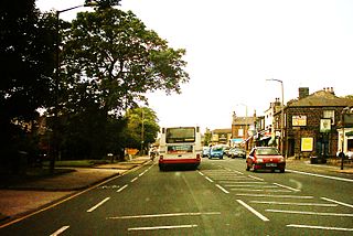
The A660 is a major road in the Leeds and Bradford districts of West Yorkshire, England that runs from Leeds city centre to Burley-in-Wharfedale where it meets the A65. The A660 is approximately 10 miles (16 km) long, and crosses the watershed from Airedale to lower Wharfedale. For most of its length the road is in the metropolitan district of the City of Leeds; the last 0.4 miles (0.6 km) is in City of Bradford district.

Headingley Parish Church or the Parish Church of St Michael and All Angels in Headingley, a suburban area of Leeds, West Yorkshire, England is a large Victorian Church of England parish church in the centre of the parish on Otley Road.

Ilkley is a town and civil parish in West Yorkshire, in the north of England. It has been inhabited since at least the Mesolithic period; was the site of a Roman fort, and much later an early example of a spa town. In more recent times it serves as a residential district within the travel to work areas of Bradford, Leeds and Keighley.

The Golden Beam is a pub and Grade II listed building located in the Headingley area of Leeds, West Yorkshire, England. It was built in c. 1912 for the Church of Christ, Scientist, and was known as the Elinor Lupton Centre from 1986 to 2010 when it was a school arts centre. It was designed by Piet de Jong and William Peel Schofield from the architectural firm Schofield and Berry. Constructed in white Portland stone in a mixed style of Egyptian Revival and Art Deco, it was originally built as a Sunday school in c. 1912–1914, extended in the 1930s with a church building and then used by the Leeds Girls' High School as a theatre and music centre from 1986 until 2010. The structure has architectural significance in the locality due to its distinct style and use of materials; many original features and fittings survive, including the entrance foyer, two staircases and a glazed lantern in the auditorium roof.