Related Research Articles

Wittenoom is a former town and a declared contaminated site, 1,420 kilometres (880 mi) north-north-east of Perth, in the Hamersley Range in the Pilbara region of Western Australia. The declared contaminated site comprises 50,000 hectares, making it the "largest contaminated site in the southern hemisphere".
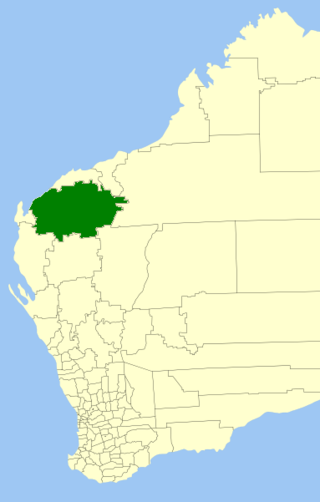
The Shire of Ashburton is one of the four local government areas in the Pilbara region of Western Australia, covering an area of 105,647 square kilometres (40,791 sq mi). It is named after the Ashburton River.

Onslow is a coastal town in the Pilbara region of Western Australia, 1,386 kilometres (861 mi) north of Perth. It has a population of 848 people and is located within the Shire of Ashburton local government area.

The electoral district of Pilbara is a Legislative Assembly electorate in the state of Western Australia. Pilbara is named for the region of Western Australia in which it is located. It is one of the oldest electorates in Western Australia, with its first member having been elected to the Second Parliament of the Legislative Assembly at the 1894 elections.

Wollondilly Shire is a periurban local government area, located on the south west fringe of the Greater Sydney area in New South Wales, Australia, parts of which fall into the Macarthur, Blue Mountains and Central Tablelands regions in the state of New South Wales, Australia. Wollondilly is seen as the transition between Regional NSW and the Greater Sydney Region, and is variously categorised as part of both. Wollondilly Shire was created by proclamation in the NSW Government Gazette on 7 March 1906, following the passing of the Local Government (Shires) Act 1905, and amalgamated with the Municipality of Picton on 1 May 1940.

The Shire of Kondinin is a local government area in the eastern Wheatbelt region of Western Australia, about 300 kilometres (186 mi) east of the state capital, Perth. The Shire's land area of 7,376 square kilometres (2,848 sq mi) forms a narrow east-west band, located between the Shire of Narembeen to the north and the Shire of Kulin to the south. Its seat of government is the town of Kondinin.

Cooran is a rural hinterland town and locality in the Shire of Noosa, Queensland, Australia. In the 2021 census, the locality of Cooran had a population of 1,756 people.

Boolaloo Station, commonly referred to as Boolaloo, is a pastoral lease that once operated as a sheep station but now operates as a cattle station in Western Australia.
Glenflorrie Station, also known as Glen Florrie Station, is a pastoral lease that operates as a cattle station. It is located about 147 kilometres (91 mi) south of Pannawonica and 175 kilometres (109 mi) west of Paraburdoo in the Pilbara region of Western Australia, and occupies an area of 1,970 square kilometres (761 sq mi).
Ashburton Downs Station, often referred to as Ashburton Downs, is a pastoral lease that once operated as a sheep station and presently operates as a cattle station.
Maroonah Station, often referred to as Maroonah, is a pastoral lease that operates as a sheep station.
Peedamulla Station, often referred to as Peedamulla, is a pastoral lease that currently operates as a cattle station but once operated as a sheep station.
The original Shire of Ashburton was a local government area in Western Australia from 1887 to 1972. It was based in the town of Onslow.
The Shire of Donnybrook was a local government area in Western Australia. It was based in the town of Donnybrook. It was established as the Preston Road District on 10 July 1896.

Broadmount is an abandoned riverside town in the Livingstone Shire, Queensland, Australia. It is within the locality of Thompson Point. From 1899 to 1929 it operated as a port serving Central Queensland.
The Shire of Marble Bar was a local government area in the Pilbara region of Western Australia. It was established as the Bamboo Road District on 4 September 1896, and was based in the now-former town of Bamboo Creek. The first election was held in January 1897.
The Shire of Nullagine was a local government area in the Pilbara region of Western Australia.
The Town of Carnarvon was a local government area in Western Australia.
The Municipality of Broome was a local government area in Western Australia centred on the coastal town of Broome. It existed from 1904 to 1918.
The Bunbury Road District was an early form of local government area in the region surrounding Bunbury, Western Australia from 1899 to 1950.
References
- ↑ "TABLELAND ROADS BOARD". Northern Public Opinion And Mining And Pastoral News . Western Australia. 4 April 1902. p. 3. Retrieved 12 January 2020– via Trove.
- ↑ "Advertising". Northern Times . Western Australia. 26 February 1938. p. 2. Retrieved 12 January 2020– via Trove.
- ↑ "Advertising". Northern Times . Western Australia. 14 July 1949. p. 6. Retrieved 12 January 2020– via Trove.
- ↑ "Advertising". Northern Times . Western Australia. 12 June 1942. p. 2. Retrieved 12 January 2020– via Trove.
- 1 2 3 "Municipality Boundary Amendments Register" (PDF). Western Australian Electoral Distribution Commission. Retrieved 11 January 2020.