Bulgaria is a country situated in Southeast Europe, bordering Romania to the north, Serbia and North Macedonia to the west, Greece and Turkey to the south, and the Black Sea to the east. The northern border with Romania follows the river Danube until the city of Silistra. The land area of Bulgaria is 110,879 square kilometres (42,811 sq mi), slightly larger than that of Iceland or the U.S. state of Tennessee. Considering its relatively small size, Bulgaria has a great variety of topographical features. Even within small parts of the country, the land may be divided into plains, plateaus, hills, mountains, basins, gorges, and deep river valleys. The geographic center of Bulgaria is located in Uzana.
Ruse (also transliterated as Rousse, Russe; Bulgarian: Русе, pronounced [ˈrusɛ], is the fifth largest city in Bulgaria. Ruse is in the northeastern part of the country, on the right bank of the Danube, opposite the Romanian city of Giurgiu, approximately 75 km south of Bucharest, Romania's capital, 200 km from the Bulgarian Black Sea Coast and 300 km from the capital Sofia. It is the most significant Bulgarian river port, serving an important part of the international trade of the country.

The Rhodopes are a mountain range in Southeastern Europe, with over 83% of its area in southern Bulgaria and the remainder in Greece. Golyam Perelik is its highest peak at 2,191 meters (7,188 ft). The mountain range gives its name to the terrestrial ecoregion Rodope montane mixed forests that belongs in the Temperate broadleaf and mixed forests Biome and the Palearctic ecozone. The region is particularly notable for its karst areas with their deep river gorges, large caves and specific sculptured forms, such as the Trigrad Gorge.
The Struma or Strymónas is a river in Bulgaria and Greece. Its ancient name was Strymṓn. Its drainage area is 17,330 km2 (6,690 sq mi), of which 10,797 km2 (4,169 sq mi) in Bulgaria, 6,295 km2 (2,431 sq mi) in Greece and the rest in the Republic of Macedonia. It takes its source from the Vitosha Mountain in Bulgaria, runs first westward, then southward, forming a number of gorges, enters Greek territory at the Kula village. In Greece it is the main waterway feeding and exiting from Lake Kerkini, a significant centre for migratory wildfowl. The river flows into the Strymonian Gulf in Aegean Sea, near Amphipolis in the Serres regional unit. The river's length is 415 kilometres.
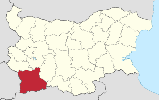
Blagoevgrad Province, also known as Pirin Macedonia is a province (oblast) of southwestern Bulgaria. It borders four other Bulgarian provinces to the north and east, to the Greek region of Macedonia to the south, and North Macedonia to the west. The province has 14 municipalities with 12 towns. Its principal city is Blagoevgrad, while other significant towns include Bansko, Gotse Delchev, Melnik, Petrich, Razlog, Sandanski, and Simitli.

The Maritsa, Meriç or Evros is, with a length of 480 km (300 mi), the longest river that runs solely in the interior of the Balkans. Its drainage area is about 53,000 km2 (20,000 sq mi), of which 66.2% in Bulgaria, 27.5% in Turkey and 6.3% in Greece. It has its origin in the Rila Mountains in Western Bulgaria, flowing southeast between the Balkan and Rhodope Mountains, past Plovdiv and Parvomay to Edirne, Turkey. East of Svilengrad, Bulgaria, the river flows eastwards, forming the border between Bulgaria and Greece, and then between Turkey and Greece. At Edirne, the river flows through Turkish territory on both banks, then turns towards the south and forms the border between Greece on the west bank and Turkey on the east bank to the Aegean Sea. Turkey was given a small sector on the west bank opposite the city of Edirne. The river enters the Aegean Sea near Enez, where it forms a river delta. The Tundzha is its chief tributary; the Arda is another one. The lower course of the Maritsa/Evros forms part of the Bulgarian-Greek border and most of the Greek–Turkish border. The upper Maritsa valley is a principal east-west route in Bulgaria. The unnavigable river is used for power production and irrigation.

Madan is a town in Smolyan Province, the very south of Bulgaria in the Yellow Share of the Rhodope Mountains. It is the administrative centre of the homonymous Madan Municipality. As of December 2009, the town has a population of 6,007 inhabitants.

Nikopol is a town in northern Bulgaria, the administrative center of Nikopol municipality, part of Pleven Province, on the right bank of the Danube river, 4 kilometres downstream from the mouth of the Osam river. It spreads at the foot of steep chalk cliffs along the Danube and up a narrow valley. As of December 2009, the town has a population of 3,892 inhabitants.
Byala Cherkva is a town in Pavlikeni Municipality part of Veliko Turnovo Province, Central-North Bulgaria. The settlement is located close to the town of Pavlikeni about 28 km away from the city of Veliko Tarnovo. Its name in Bulgarian means white church, a popular placename around the world, equivalent to Bela Crkva, Weisskirchen, Whitechurch, etc. As of December 2009, the town has a population of 2,612 inhabitants.

The Iskar is a right tributary of the Danube. With a length of 368 km it is the longest river that runs entirely within Bulgaria. Originating as three forks in Balkan's highest mountain range Rila, it flows in northern direction until its confluence with the Danube River. As it flows northwards it fuels the largest artificial lake in the country, the Iskar Reservoir, forms the divide between the Vitosha and Plana Mountains in the west and the Sredna Gora mountain range in the east before entering the Sofia Valley, which contains the nation's capital Sofia. From there the Iskar runs through the Balkan Mountains forming the spectacular 84 km long Iskar Gorge and as it crosses the mountains its water course turns in north-eastern direction at Lakatnik. North of the Balkan Mountains the river crosses the Danubian Plain and finally flows into the Danube between the villages of Baykal and Gigen. Geologically, Iskar is the oldest river in the Balkan Peninsula.

The Nestos or Mesta, formerly the Mesta Karasu, is a river in Bulgaria and Greece. It rises in the Rila Mountains and flows into the Aegean Sea near the island of Thasos. It plunges down towering canyons toward the Aegean Sea through mostly metamorphic formations. At the end, the main stream spreads over the coastal plain of Chrysoupolis and expands as a deltaic system with freshwater lakes and ponds forming the Nestos delta.The length of the river is 230 km (140 mi), of which 126 km (78 mi) flow through Bulgaria and the rest in Greece. Its drainage area is 5,184 km2 (2,002 sq mi), of which 66% in Bulgaria. It forms some gorges in Rila and Pirin.
Svoge is a town in western Bulgaria, part of Sofia Province. It is located in the gorge of the Iskar River, at the place where the mountains Mala planina, Golema planina and Ponor meet, 40 km north of the capital Sofia. Svoge is the main town of the Svoge Municipality which is one of the largest municipalities in Bulgaria and includes also 37 villages & the town of Svoge itself.

Dryanovo is a Bulgarian town situated at the northern foot of the Balkan Mountains in Gabrovo Province; amphitheatrically along the two banks of Dryanovo River, a tributary to the Yantra River. The town is a centre of the homonymous Dryanovo Municipality, which is composed of 62 villages, hamlets and huts picturesquely spread out of the mountain folds. As of 2015, it has a population of 7,968. In 2009, it was 8,043.
Chirpan is a town on the Tekirska River in Stara Zagora Province of south-central Bulgaria. It is the administrative centre of the homonymous Chirpan Municipality. As of December 2013, the town had a population of 15,109 down from 16,355 inhabitants in December 2009.

Krichim is a town in Bulgaria, located in the southwestern part of Plovdiv Province close to Perushtitsa. It lies at the foot of the Rhodopes' northern slopes in the plains of Thrace, 20 km southwest of Plovdiv. The river Vacha, an important tributary of the Maritsa, runs through the town. Krichim is the only place in Krichim Municipality.
Gulyantsi is a town in central northern Bulgaria, part of Pleven Province. It is the administrative centre of Gulyantsi municipality and lies in the central north of the province, near the town of Nikopol, very close to the Danube River. As of December 2009, the town has a population of 3,432 inhabitants.

The Danube, known by various names in other languages, is Europe's second longest river, after the Volga. It is located in Central and Eastern Europe.

Lom Municipality is a frontier municipality (obshtina) in Montana Province, Northwestern Bulgaria, located along the right bank of Danube river in the Danubian Plain. It is named after its administrative centre — the town of Lom which is one of the important Bulgarian river ports. The area borders Romania across the Danube.