Shkotovo

Last updated

Coordinates: 43°19′N132°21′E / 43.317°N 132.350°E / 43.317; 132.350

Geographic coordinate system Coordinate system

A geographic coordinate system is a coordinate system that enables every location on Earth to be specified by a set of numbers, letters or symbols. The coordinates are often chosen such that one of the numbers represents a vertical position and two or three of the numbers represent a horizontal position; alternatively, a geographic position may be expressed in a combined three-dimensional Cartesian vector. A common choice of coordinates is latitude, longitude and elevation. To specify a location on a plane requires a map projection.

Contents

Shkotovo (Russian : Шко́тово) is an urban locality (an urban-type settlement) and a railway station in Shkotovsky District of Primorsky Krai, Russia. Population: 5,038(2010 Census); [1] 5,348(2002 Census); [2] 7,721(1989 Census). [3]

Russian language East Slavic language

Russian is an East Slavic language, which is official in the Russian Federation, Belarus, Kazakhstan and Kyrgyzstan, as well as being widely used throughout Eastern Europe, the Baltic states, the Caucasus and Central Asia. It was the de facto language of the Soviet Union until its dissolution on 25 December 1991. Although, nowadays, over two decades after the breakup of the Soviet Union, Russian is used in official capacity or in public life in all the post-Soviet nation-states, as well as in Israel and Mongolia, the rise of state-specific varieties of this language tends to be strongly denied in Russia, in line with the Russian World ideology.

The classification system of the types of inhabited localities in Russia, the former Soviet Union, and some other post-Soviet states has certain peculiarities compared with the classification systems in other countries.

Urban-type settlement is an official designation for a semi-urban settlement, used in several Eastern European countries. The term was historically used in Bulgaria, Poland, and the Soviet Union, and remains in use today in 10 of the post-Soviet states.

History

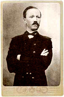
It was founded in 1865 as a village at the mouth of the Tsymukhe River (now Shkotovka River) on the Ussuri Bay and was granted urban-type settlement status in 1931. It is named after Nikolay Shkot.

The Shkotovka River is a river in Primorsky Krai, Russia.

Ussuri Bay bay

Ussuri Bay is a major bay within Peter the Great Gulf of the Sea of Japan.

Nikolay Shkot Russian explorer

Nikolay Yakovlevich Shkot was a Russian sailor and explorer, best known for one of the earliest expeditions of the Russian Far East, and as a founder of Vladivostok.

Economy

There are a car repair service, a tinned food plant, and a dairy factory in Shkotovo.

Related Research Articles

Tavda human settlement in Russia

Tavda is a town in Sverdlovsk Oblast, Russia, located on the Tavda River and functioning as a river port. Population: 35,421 (2010 Census); 40,686 (2002 Census); 45,735 (1989 Census).

Kavalerovo is an urban locality and the administrative center of Kavalerovsky District of Primorsky Krai, Russia. Population: 15,381 (2010 Census); 17,358 (2002 Census); 19,336 (1989 Census).

Smolyaninovo is an urban locality and the administrative center of Shkotovsky District of Primorsky Krai, Russia, located 45 kilometers (28 mi) from Vladivostok; 73 kilometers (45 mi) by road. Population: 6,715 (2010 Census); 6,448 (2002 Census); 18,831 (1989 Census).

Ushkovo, Saint Petersburg

Ushkovo is a municipal settlement in Kurortny District of the federal city of St. Petersburg, Russia, located on the Karelian Isthmus, on the northern shore of the Gulf of Finland. Population: 618 (2010 Census); 482 (2002 Census); 6,031 (1989 Census).

Yaroslavsky is an urban locality in Khorolsky District of Primorsky Krai, Russia, located 30 kilometers (19 mi) southeast of the district's administrative center of Khorol. Population: 9,104 (2010 Census); 10,254 (2002 Census); 11,715 (1989 Census).

Oktyabrsky, Oktyabrsky District, Perm Krai Work settlement in Perm Krai, Russia

Oktyabrsky is an urban locality and the administrative center of Oktyabrsky District of Perm Krai, Russia. Population: 9,845 (2010 Census); 10,039 (2002 Census); 8,961 (1989 Census).

Bely Yar, Khanty-Mansi Autonomous Okrug Urban-type settlement in Khanty-Mansi Autonomous Okrug, Russia

Bely Yar is an urban locality in Surgutsky District of Khanty-Mansi Autonomous Okrug, Russia. Population: 14,580 (2010 Census); 14,392 (2002 Census); 13,004 (1989 Census).

Tayozhny, Khanty-Mansi Autonomous Okrug Urban-type settlement in Khanty-Mansi Autonomous Okrug, Russia

Tayozhny is an urban locality in Sovetsky District of Khanty-Mansi Autonomous Okrug, Russia. Population: 2,370 (2010 Census); 2,526 (2002 Census); 3,236 (1989 Census).

Novoagansk Urban-type settlement in Khanty-Mansi Autonomous Okrug, Russia

Novoagansk is an urban locality in Nizhnevartovsky District of Khanty-Mansi Autonomous Okrug, Russia. Population: 10,343 (2010 Census); 9,717 (2002 Census); 10,050 (1989 Census).

Beryozovka, Beryozovsky District, Krasnoyarsk Krai Urban-type settlement in Krasnoyarsk Krai, Russia

Beryozovka is an urban locality in Beryozovsky District of Krasnoyarsk Krai, Russia. Population: 20,887 (2010 Census); 21,346 (2002 Census); 20,766 (1989 Census).

Koshurnikovo Urban-type settlement in Krasnoyarsk Krai, Russia

Koshurnikovo is an urban locality in Kuraginsky District of Krasnoyarsk Krai, Russia. Population: 3,492 (2010 Census); 3,802 (2002 Census); 5,163 (1989 Census).

Novochernorechensky Urban-type settlement in Krasnoyarsk Krai, Russia

Novochernorechensky is an urban locality in Kozulsky District of Krasnoyarsk Krai, Russia. Population: 3,802 (2010 Census); 3,781 (2002 Census); 4,451 (1989 Census).

Razdolinsk Urban-type settlement in Krasnoyarsk Krai, Russia

Razdolinsk is an urban locality in Motyginsky District of Krasnoyarsk Krai, Russia. Population: 2,502 (2010 Census); 2,806 (2002 Census); 3,800 (1989 Census).

Sayansky (urban-type settlement) Urban-type settlement in Krasnoyarsk Krai, Russia

Sayansky is an urban locality in Rybinsky District of Krasnoyarsk Krai, Russia. Population: 4,047 (2010 Census); 4,025 (2002 Census); 3,957 (1989 Census).

Severo-Yeniseysky (urban-type settlement) Urban-type settlement in Krasnoyarsk Krai, Russia

Severo-Yeniseysky is an urban locality in Severo-Yeniseysky District of Krasnoyarsk Krai, Russia. Population: 6,950 (2010 Census); 6,668 (2002 Census); 10,143 (1989 Census).

Cherusti Urban-type settlement in Moscow Oblast, Russia

Cherusti is an urban locality in Shatursky District of Moscow Oblast, Russia. Population: 2,862 (2010 Census); 2,891 (2002 Census); 3,779 (1989 Census).

Zhilyovo Urban-type settlement in Moscow Oblast, Russia

Zhilyovo is an urban locality in Stupinsky District of Moscow Oblast, Russia. Population: 2,472 (2010 Census); 2,468 (2002 Census); 2,733 (1989 Census).

Leninskoye is a rural locality (a and the administrative center of Leninsky District of the Jewish Autonomous Oblast, Russia. Population: 6,109  ; 7,048  ; 6,707  .

Dorogino Urban-type settlement in Novosibirsk Oblast, Russia

Dorogino is an urban locality in Cherepanovsky District of Novosibirsk Oblast, Russia. Population: 3,829 (2010 Census); 3,811 (2002 Census); 4,132 (1989 Census).

Verkhny At-Uryakh Urban-type settlement in Magadan Oblast, Russia

Verkhny At-Uryakh is an urban locality in Yagodninsky District of Magadan Oblast, Russia. Population: 0 (2010 Census); 61 (2002 Census); 1,258 (1989 Census).

References

  1. Russian Federal State Statistics Service (2011). "Всероссийская перепись населения 2010 года. Том 1" [2010 All-Russian Population Census, vol. 1]. Всероссийская перепись населения 2010 года (2010 All-Russia Population Census) (in Russian). Federal State Statistics Service . Retrieved June 29, 2012.
  2. Russian Federal State Statistics Service (May 21, 2004). "Численность населения России, субъектов Российской Федерации в составе федеральных округов, районов, городских поселений, сельских населённых пунктов – районных центров и сельских населённых пунктов с населением 3 тысячи и более человек" [Population of Russia, Its Federal Districts, Federal Subjects, Districts, Urban Localities, Rural Localities—Administrative Centers, and Rural Localities with Population of Over 3,000](XLS). Всероссийская перепись населения 2002 года [All-Russia Population Census of 2002] (in Russian). Retrieved August 9, 2014.
  3. Demoscope Weekly (1989). "Всесоюзная перепись населения 1989 г. Численность наличного населения союзных и автономных республик, автономных областей и округов, краёв, областей, районов, городских поселений и сёл-райцентров" [All Union Population Census of 1989: Present Population of Union and Autonomous Republics, Autonomous Oblasts and Okrugs, Krais, Oblasts, Districts, Urban Settlements, and Villages Serving as District Administrative Centers]. Всесоюзная перепись населения 1989 года [All-Union Population Census of 1989] (in Russian). Институт демографии Национального исследовательского университета: Высшая школа экономики [Institute of Demography at the National Research University: Higher School of Economics]. Retrieved August 9, 2014.