
The history of Richmond, Virginia, as a modern city, dates to the early 17th century, and is crucial to the development of the colony of Virginia, the American Revolutionary War, and the Civil War. After Reconstruction, Richmond's location at the falls of the James River helped it develop a diversified economy and become a land transportation hub.
The Greater Richmond, Virginia area has many neighborhoods and districts.

Shockoe Hill is one of several hills on which much of the oldest portion of the City of Richmond, Virginia, U.S., was built. It extends from the downtown area, including where the Virginia State Capitol complex sits, north almost a mile to a point where the hill falls off sharply to the winding path of Shockoe Creek. Interstate 95 now bisects the hill, separating the highly urbanized downtown portion from the more residential northern portion.

Jackson Ward, previously known as Central Wards, is a historically African-American district in Richmond, Virginia, with a long tradition of African-American businesses. It is located less than a mile from the Virginia State Capitol, sitting to the west of Court End and north of Broad Street. It was listed as a National Historic Landmark District in 1978. "Jackson Ward" was originally the name of the area's political district within the city, or ward, from 1871 to 1905, yet has remained in use long after losing its original meaning.

Richmond National Cemetery is a United States National Cemetery three miles (4.8 km) east of Richmond in Henrico County, Virginia. Administered by the United States Department of Veterans Affairs, it encompasses 9.7 acres (3.9 ha), and as of 2021 had more than 11,000 interments. It is closed to new interments. Richmond National Cemetery was listed on the National Register of Historic Places in 1995.

Shockoe Bottom, historically known as Shockoe Valley, is an area in Richmond, Virginia, just east of downtown, along the James River. Located between Shockoe Hill and Church Hill, Shockoe Bottom contains much of the land included in Colonel William Mayo's 1737 plan of Richmond, making it one of the city's oldest neighborhoods.
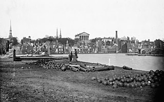
Richmond, Virginia, served as the capital of the Confederate States of America during the American Civil War from May 1861 to April 1865. Besides its political status, it was a vital source of weapons and supplies for the war effort, as well as the terminus of five railroads; as such, it would have been defended by the Confederate States Army at all costs.

Oakwood Cemetery is a large, city-owned burial ground in the East End of Richmond, Virginia. It holds over 48,000 graves, including many soldiers from the Civil War.

The Hebrew Cemetery in Richmond, Virginia, also known as Hebrew Burying Ground, and previously the Jew's Burying Ground, dates from 1816. This Jewish cemetery, one of the oldest in the United States, was founded in 1816 as successor to the Franklin Street Burial Grounds of 1789. Among those interred here is Josephine Cohen Joel, who was well known in the early 20th century as the founder of Richmond Art Co. Within Hebrew Cemetery is a plot known as the Soldier's Section. It contains the graves of 30 Jewish Confederate soldiers who died in or near Richmond. It is one of only two Jewish military cemeteries outside of the State of Israel.
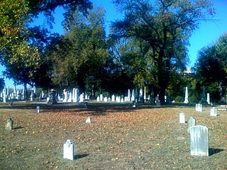
The Shockoe Hill Cemetery is a historic cemetery located on Shockoe Hill in Richmond, Virginia.

The VCU Medical Center, formerly known as the Medical College of Virginia (MCV), is the medical campus of Virginia Commonwealth University (VCU), located in downtown Richmond, Virginia, United States. As MCV, VCU Medical Center merged with the Richmond Professional Institute in 1968 to create VCU. In the 1990s, the Medical College of Virginia Hospitals Authority was created to oversee MCV Hospitals. In 2004, the name of this authority was changed to the VCU Health System, and the MCV Hospitals and surrounding campus were named the VCU Medical Center. The authority oversees the employees and real estate occupied by the five schools within the VCU Medical Center. It was at this time that the MCV Campus moniker was created.

The Fifth Street Viaduct or the Fifth Street Bridge, officially the Curtis Holt Sr. Bridge, is a bridge crossing Bacon's Quarter Branch in the Shockoe Valley of Richmond, Virginia in the United States. It carries automobile and pedestrian traffic between Downtown Richmond's Jackson Ward and Gilpin Court with the North Side's Chestnut Hill and Highland Park.
The following is a timeline of the history of the city of Richmond, Virginia, United States

The Chestnut Hill–Plateau Historic District is a historic area in the Highland Park neighborhood of Richmond, Virginia. It is also known as 'Highland Park Southern Tip' on city neighborhood maps.

The Almshouse, also known as the City Home is a historic almshouse and hospital complex located in Richmond, Virginia.
The Shockoe Hill African Burying Ground was established by the city of Richmond, Virginia, for the interment of free people of color, and the enslaved. The heart of this now invisible burying ground is located at 1305 N 5th St.
The Shockoe Bottom African Burial Ground, known historically as the "Burial Ground for Negroes" and the "old Powder Magazine ground", is the older of two municipal burial grounds established for the interment of free people of color and the enslaved in the city of Richmond, Virginia. It is located at 1554 E Broad St., across from the site of Lumpkin's Jail, in Shockoe Bottom. The area now known as Shockoe Bottom, was historically known as Shockoe Valley. Richmond's second African Burial Ground, called the Shockoe Hill African Burying Ground is the larger of the two burial grounds, and is located a mile and a half away at 1305 N 5th St, on Shockoe Hill.
The city of Richmond, Virginia has two African Burial Grounds, the "Shockoe Bottom African Burial Ground", and the "Shockoe Hill African Burying Ground". Additionally the city is home to several other important and historic African American cemeteries.

Shockoe Creek is a watercourse in Virginia, United States, tributary to the James River. The Shockoe Creek watershed drained "portions of Richmond's North Side, near West End, downtown and northeast Henrico County." Historic tributaries of Shockoe Creek included Bacon's Quarter Branch and Gum Tree Creek.
