
Short Heath is an area of Birmingham, England near to Erdington. The area's postcode is B23. [1]
Short Heath is an area of Birmingham, England near to Erdington. The area's postcode is B23. [1]
Balsall Heath is an inner-city area of Birmingham, West Midlands, England. It has a diverse cultural mix of people and is the location of the Balti Triangle.

The Metropolitan Borough of Solihull is a metropolitan borough in West Midlands county, England. It is named after its largest town, Solihull, from which Solihull Metropolitan Borough Council is based. For Eurostat purposes it is a NUTS 3 region and is one of seven boroughs or unitary districts that comprise the "West Midlands" NUTS 2 region. Much of the large residential population in the north of the borough centres on the communities of Castle Bromwich, Kingshurst, Marston Green and Smith's Wood as well as the towns of Chelmsley Wood and Fordbridge. In the south are the towns of Shirley and Solihull, as well as the large villages of Knowle, Dorridge, Meriden and Balsall Common.

Yardley is an area in east Birmingham, England. It is also a council constituency, managed by its own district committee. Historically it lay within Worcestershire.

Sparkhill is an inner-city area of Birmingham, England, situated between Springfield, Hall Green and Sparkbrook.

Birmingham, Sparkbrook and Small Heath was a parliamentary constituency represented in the House of Commons of the Parliament of the United Kingdom. It elected one Member of Parliament (MP) by the first-past-the-post system of election. The constituency was notable for having the largest percentage of Muslim voters of any UK constituency at 48.8%.

Wake Green is a historical area in south Birmingham, England between Moseley, Kings Heath, and Hall Green.

Whitlocks End railway station is a railway station on the North Warwickshire Line located next to, and named after the hamlet of Whitlock's End in the West Midlands of England. It lies a short distance from several villages: Tidbury Green and the new village of Dickens Heath in the West Midlands, and Major's Green and Hollywood in Worcestershire. The station, and all trains serving it, are operated by West Midlands Trains.
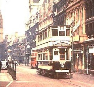
Birmingham Corporation Tramways operated a network of tramways in Birmingham from 1904 until 1953. It was the largest narrow-gauge tramway network in the UK, and was built to a gauge of 3 ft 6 in. It was the fourth largest tramway network in the UK behind London, Glasgow and Manchester.

King's Norton and Northfield Urban District was a local government administrative district in north Worcestershire, England, from 1898 until 1911. Much of its area was afterwards absorbed into the neighbouring Borough of Birmingham, under the Greater Birmingham Scheme, and now constitutes most of the city's southern and southwestern suburban environs.

The Ridgacre Branch is a canal branch of the Wednesbury Old Canal, part of the Birmingham Canal Navigations, in the West Midlands, England. It opened in 1828, to serve collieries and iron works, and was disused by the 1960s. Except for its branches and a small section at the eastern end, which have been filled in, most of it is still in water, but it is not navigable as a low-level bridge carrying the Black Country New Road spans the entrance.

Warstock is a district within the city of Birmingham, UK, in the southernmost suburbs roughly 1 km east of the A435 and within the ward of Highter's Heath. The area lies within the B14 postcode and is contiguous with Yardley Wood to the north-east, Solihull Lodge to the south-east and Highter's Heath to the south-west. Kings Heath lies to the north-west.

Central Jamia Mosque Ghamkol Sharif is a Sunni mosque in Small Heath area of Birmingham, England.
Little Bromwich is a small area in central-east Birmingham, England. It borders with Bordesley Green and Small Heath and there is a road named after it. It is also quite close to Yardley, and often confused with part of Bordesley Green.

Brandwood End is a locality in Birmingham, England, and makes up the central part of the Brandwood electoral ward. It lies within the B14 postcode and is a sub-area of Kings Heath. The area is centred on Brandwood End Cemetery.
Walker's Heath is a small area spanning the southern border of the city of Birmingham, England and the Bromsgrove District of Worcestershire. It is located to the immediate south-east of the Birmingham suburb of Kings Norton.

Gib Heath is a small area of Birmingham, England. It is an inner-city area generally considered to be a part of Handsworth.
Highter's Heath is a district and ward lying on the southern boundary of the city of Birmingham, UK. The district of Highter's Heath lies immediately east of the Maypole. The first recorded use of the name dates from 1495 as Heyters Heath, however today the name is not one that is particularly in widespread use, indeed only three signposted references to the name exist, when entering the city along Maypole Lane, when entering the city from the bottom of Highters Heath Lane and in Major's Green.

Bordesley Hall was an 18th century manor house near Bordesley, Birmingham, which stood in a 15 hectare park south of the Coventry Road in an area between what is now Small Heath and Sparkbrook. The Georgian house was the successor to an earlier medieval moated manor.
King Edward VI Sheldon Heath Academy is a mixed secondary school and sixth form located in the Sheldon area of Birmingham, in the West Midlands of England.
Saltley Academy is a mixed secondary school located in the Bordesley Green area of Birmingham, in the West Midlands of England.
52°31′54″N1°51′29″W / 52.5317°N 1.8581°W
| | This West Midlands location article is a stub. You can help Wikipedia by expanding it. |