Bareilly is a metropolitan city in Bareilly district in the Indian state of Uttar Pradesh. It is among the largest metropolises in Western Uttar Pradesh and is the centre of the Bareilly division as well as the historical region of Rohilkhand. The city lies in the Indo-Gangetic Plains, about 252 kilometres (157 mi) north west of the state capital, Lucknow, and 250 kilometres (155 mi) east of the national capital, New Delhi. With a population of 898,167 in 2011, it is the eighth most populous city in the state, seventeenth in northern India and fifty-fourth in India. It is located on the bank of Ramganga River and is the site of the Ramganga Barrage built for canal irrigation.

Harit Pradesh is a proposed new state of India comprising the western parts of Uttar Pradesh state. Harit means Green which signifies the agricultural prosperity of the region and Pradesh means state.

Haldwani is the third most populous city and largest commercial market in the Indian state of Uttarakhand. It is also the largest city of the Kumaon region. Haldwani is said to be the financial capital of Uttarakhand, having the most commercial, economic and industrial activities of the state. Haldwani is located in the Nainital District, and is one of its eight Subdivisions. The Haldwani Urban agglomeration has 232,060 people as of 2011, and is the fourth most populous UA in Uttarakhand, after Dehradun, Haridwar and Roorkee. Being situated in the immediate foothills of Kumaon Himalayas, the Kathgodam neighbourhood of Haldwani is known as the "Gateway to Kumaon".

Etah district is one of the districts of Uttar Pradesh, India, since 1854. Etah City is the district headquarters. Etah district is a part of Aligarh Division.

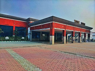
Izzatnagar is a locality in Bareilly in the Indian state of Uttar Pradesh. The railway station it houses is one of the Divisional Headquarters of North Eastern Railways. Izzatnagar is also the location of the Indian Veterinary Research Institute (IVRI), Central Avian Research Institute (CARI), Railway Mechanical Workshop [Established in year 1913], Diesel Loco Shed and Hartmann College.
Bisalpur is a City and a municipal board situated in the Pilibhit district of the state of Uttar Pradesh, India. The town is known for its sugar factory as well as its annual Ram Leela and Dushera festival. Bisalpur is in between the two rivers, in West Doha river and in East katna river. Before formation of new District Pilibhit, Bisalpur was under the District Bareilly. In 1913 AD after formation of new District Pilibhit, Bisalpur has come under District Pilibhit Administration. this city is well connected with 03 major cities. Bisalpur is just 290 km away from National capital New Delhi and 250 km from the state capital Lucknow. Bisalpur is famous for Annual Ramleela Fest, Dubey Taalab, Guleshwarnath Temple and Nagaich Market.It is also famous for SHIVAY TRADERS, a complete paint shop that is situated on the station road. Another important place is its railway station which has been modified for the broadgauge .This will really help to get well connected with different cities of india.
Deoranian is a town and a nagar panchayat in Bareilly district in the state of Uttar Pradesh, India.
Gola Gokaran Nath or Gola is the largest city/town, municipal board, thana and tehsil in Lakhimpur Kheri district in the Indian state of Uttar Pradesh.
Rithora is a town and a nagar panchayat in Bareilly Tehsil of Bareilly district in the Indian state of Uttar Pradesh.
The Old Allahabad City, at the south of Prayagraj Junction Railway Station, consists of neighborhoods like Chowk, Johnstongunj, Dariyabad, Khuldabad etc. and was in existence from the time of Akbar. Some magnificent structures erected in this era consist of the Khusro Bagh and the Allahabad Fort. In the north of Railway Station, the New Allahabad City consists of neighborhoods like Lukergunj, Civil Lines, Georgetown, Tagoretown, Bharadwaj Puram, Ashok Nagar, Mumfordgunj etc., which are relatively new and were built during the British rule. These neighborhoods reflect British architecture like the All Saints Cathedral, Alfred Park and Allahabad High Court. Newer residential areas include neighborhoods like Kareli and suburbs like Naini Jhunsi and Manauri bajar.
Ramganga is a tributary of the river Ganges, originating in Uttarakhand state, India.

Nawabganj is a Nagar palika and an administrative subdivision of Bareilly district in the Indian state of Uttar Pradesh. A Sub Divisional Magistrate, also called Sub Divisional Officer, or pargana-adhikari is the head official.
Uttar Pradesh State Highway 37 or SH 37 is a State Highway in the state of Uttar Pradesh, India that connects Bareilly to Kichha, running through Baheri.
The Bareilly Metro is a rapid transit system planned in the Indian city of Bareilly, Uttar Pradesh. The complete system will consist of 6 Metro Rail lines running throughout the metropolitan area of the city and connecting it with nearby satellite towns.

Moradabad railway station is located in Moradabad district in the Indian state of Uttar Pradesh and serves Moradabad which is namesake for its brassware industries. Moradabad is major railway station of Western Uttar Pradesh and located just 157 kilometres (98 mi) from national capital New Delhi, Moradabad also has the divisional headquarters of Northern Railway. Rajdhani, Shatabdi, Garib Rath Express, Double Decker Express and many Superfast Express trains pass through and stop at Moradabad Junction.
National Public School is a co-educational CBSE school in Bareilly, Uttar Pradesh situated at Nainital Road, Bareilly and run by the trust "National Public School Society".
Bareilly Vidhan Sabha Constituency is one of the 403 constituencies of the Uttar Pradesh Legislative Assembly, India. It is a part of the Bareilly district and one of the five assembly constituencies in the Bareilly. First election in this assembly constituency was held in 2012 after the "Delimitation of Parliamentary and Assembly Constituencies Order, 2008" was passed and the constituency was formed in 2008. The constituency is assigned identification number 124. And Baheri town is the largest Tahseel of zila Bareilly, settled with Muslim Majority. Meena Bazar is a famous place in Baheri and known around the other places as a great hub for Ladies' shopping. VVPAT facility with EVMs will be here in the 2017 U.P assembly polls.

Bareilly Cantonment is a cantonment town located in the Bareilly district of the north Indian state of Uttar Pradesh.
National Highway 530B, commonly referred to as NH 530B is a national highway in India. It is a secondary route of National Highway 30. NH-530B runs completely in the state of Uttar Pradesh in India. The Highway was Notified on 06 Mar 2018, prior to which, it was a part of UP State Highway 33.


