Atta Muhammad Nur (also spelled Ata Mohammed Noor,, served as the Governor of Balkh Province in Afghanistan from 2004 to January 25, 2018. An ethnic Tajik, he worked to educate the Mujahideen after the 1979 Soviet invasion of Afghanistan, gaining the nickname "The Teacher." He then became a mujahideen resistance commander for the Jamiat-e Islami against the Soviets.
The Balkh River or Balkhab, also known in its upper reaches as the Band-e Amir River, is a river in northern Afghanistan.

The Afghanistan–Uzbekistan Friendship Bridge is a road and rail bridge across the river Amu Darya, connecting the town of Hairatan in the northern Balkh province of Afghanistan with Termez in the Surxondaryo Region of Uzbekistan. The bridge was built by the Soviet Union and opened in 1982 to supply its troops in Afghanistan.

Charkint, or Chahar Kint, is a district in Balkh Province, Afghanistan. It has a population of 32,306. The district administration is located in Shar Shar area of Charkint district, which means "four clusters/towns" - from Persian chahār, "four", and Sogdian kand, "town". The area of the district is 1,357 square kilometres (524 sq mi).

The Qadis District is located in the southern part of Badghis province, Afghanistan, between the districts Jawand in the East, Qala i Naw in the west, Muqur and Murghab in the North. In the South is the Herat province. The capital is Qadis.
Chārbōlak district is located in the western part of Balkh Province. Its capital is the village of Charbolak, 40 km northwest of Mazari Sharif. The majority of the population is Pashtun.
Chimtal District also Chemtal or Chamtal is located in the western part of Balkh province, Afghanistan. The estimated population of Chimtal in 2004 was around 81,311, with Pashtuns being predominant. The capital is Chimtal.
Nahri Shahi or Nahr-e-Shahi is a large district of Balkh Province, Afghanistan around the capital district Mazari Sharif.
Shortepa also Shor Tappeh is one of the 15 districts of Balkh province. Shortepa, a small district in Balkh Province, Afghanistan. It is situated along the Amu Darya river, across the border with Termez, Uzbekistan, and to the east Kaldar. The main village is Shor Tappeh, A at 274 m altitude.
Dawlat Abad is a district in Faryab Province, Afghanistan. The population of the district was estimated 39,000 in 2002.

Balkh University is a public university located in Mazar-i-Sharif, capital of Balkh Province in northern Afghanistan. Established in 1986, the university has about 5,500 students and is the third-largest in Afghanistan after Kabul University and Nangarhar University. Faculties include medicine, engineering, economics, journalism, literature, law and science.
Shurab or Shur Ab may refer to:

Hairatan is a border town and a port in the north of Balkh province, Afghanistan. It sits along the Amu Darya river in the Kaldar district of Balkh province. The river forms the border with neighboring Uzbekistan, and the two nations are connected by the Afghanistan–Uzbekistan Friendship Bridge. The city of Termez in Uzbekistan is close to Hairatan. The altitude of Hairatan is 300m. Hairatan became one of the major transporting, shipping, and receiving location for Afghanistan.
Fatehabad is a village in Surkh Rod District, Nangarhar Province, Afghanistan.
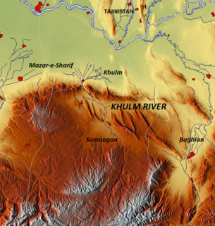
The Khulm River is a river of northern-central Afghanistan. In its upper course, it passes through Khulm and Haybak, today in Balkh Province. The Khulm is a tributary to the Oxus basin. Its source is located to the north of the city of Khulm. Further downstream, it passes through the city of Samangan and Samangan Province. The Khulm River forms the western border of Kunduz Province.
Provincial Reconstruction Team Mazar-i-Sharif is a Provincial Reconstruction Team in Afghanistan, and was part of the NATO International Security Assistance Force (ISAF) mission. Mazar-i-Sharif is a city in Balkh province which fell under the control of Regional Command North. Since 2006 the PRT's unit commanders have been Swedish military officers, on loan to ISAF. It has ISAF-soldiers that are citizens of Sweden or Finland.

On 21 April 2017, at least ten Taliban fighters attacked Camp Shaheen, headquarters of the 209 Corps of the Afghan National Army (ANA), near Mazar-i-Sharif, Balkh Province. The death toll was unclear—official Afghan government statements said about 140 people were killed and 160 injured, while media reports said as many as 256 were dead. The attack was the deadliest on an Afghan military base since the beginning of the war.


