
Shutta is a northern suburb of Looe, Cornwall, England, United Kingdom. [1]
Shutta is a northern suburb of Looe, Cornwall, England, United Kingdom. [1]
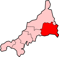
Caradon was a local government district in Cornwall, United Kingdom. It contained five towns: Callington, Liskeard, Looe, Saltash and Torpoint, and over 80 villages and hamlets within 41 civil parishes. Its District Council was based in Liskeard 50.453°N 4.465°W.

North Cornwall is an area of Cornwall, England, United Kingdom. It is also the name of a former local government district, which was administered from Bodmin and Wadebridge 50.516°N 4.835°W. Other towns in the area are Launceston, Bude, Padstow, and Camelford.

The Gover Stream is an approximately 3 kilometres (1.9 mi) long stream located in mid south Cornwall, England, United Kingdom.

The River Hayle is a small river in West Cornwall, England, United Kingdom which issues into St Ives Bay at Hayle on Cornwall's Atlantic coast.
There are seventeen disused railway stations on the Cornish Main Line between Plymouth in Devon and Penzance in Cornwall, England. The remains of nine of these can be seen from passing trains. While a number of these were closed following the so-called "Beeching Axe" in the 1960s, many of them had been closed much earlier, the traffic for which they had been built failing to materialise.

The Par River, also known as the Luxulyan River is a river draining the area north of St Blazey in Cornwall, in the United Kingdom.

The River Inny is a small river in east Cornwall, United Kingdom. It is a tributary of the River Tamar and is about twenty miles (32 km) long from its source near Davidstow on the eastern flank of Bodmin Moor to its confluence with the Tamar at Inny Foot near Dunterton.

The River Menalhyl is a river in Cornwall, England, that flows through the civil parishes of St Columb Major and Mawgan-in-Pydar. Its length is about 12 miles and it flows in a generally north-west direction. The name comes from the Cornish words melyn meaning mill and heyl meaning estuary - estuary mills. The name was recorded as Mellynheyl in the 19th century, but it had been known as Glyvion.

SS James Eagan Layne was a liberty ship. She was beached and sunk during the Second World War off Whitsand Bay, Cornwall, United Kingdom.
SS Rosehill – also known as SS Penhill – was a 2,788-tonne steel-hulled collier built in 1911 by S.P. Austin and Son of Sunderland under the name Minster. She was torpedoed by the Imperial German Navy submarine UB-40 in the English Channel off Fowey, Cornwall, England, on 23 September 1917 while en route from Cardiff, Wales, to Devonport. She was taken under tow but sank in Whitsand Bay at 18:05. Her wreck lies in 28 metres of water at 50°19.793′N4°18.520′W with her bow to the north.
SS Eastfield was a 2,150-ton armed steamship which was torpedoed by the German U-boat SM UB-57 on 27 November 1917. The wreck sits intact at 50°14.255′N4°42.262′W at a depth of 50 metres (160 ft) off Mevagissey, Cornwall. The cargo of coal can be found scattered on the sea bed nearby.
The Cornish Way is a cycle route which is part of the National Cycle Network that links Bude to Land's End. The route is via Padstow or St Austell and is 180 miles in length.
Dobwalls and Trewidland is a civil parish in south-east Cornwall, England, United Kingdom.

The River Allen in north Cornwall is one of two rivers in Cornwall which share this name. In this case the name is the result of a mistake made in 1888 by Ordnance Survey, replacing the name Layne with Allen which is the old name for the lower reaches of the Camel. The other River Allen runs through Truro.

The River Ottery is a small river in northeast Cornwall, United Kingdom. The river is about twenty miles (32 km) long from its source southeast of Otterham to its confluence with the River Tamar at Nether Bridge, two miles (3.2 km) northeast of Launceston.

The De Lank River is a small river in north Cornwall, England. It is a tributary of the River Camel and is approximately nine miles (14.5 km) long from its source on Bodmin Moor to its confluence with the Camel two miles (3 km) south of St Breward.

The St Austell River properly known as the River Vinnick, but historically called The White River, is a 12 kilometres (7.5 mi) long river located in south Cornwall, England, United Kingdom. 50.337°N 4.793°W. The river has also been known as the "red river" due to tin streaming and mining activity upstream.

The River Kensey is a river in east Cornwall, England, UK which is a tributary of the River Tamar.

The River Seaton is a river in east Cornwall, England, UK which flows southwards for 11 miles (17 km) into the English Channel.

The River Lerryn is a river in east Cornwall, England, UK, a tributary of the River Fowey. The Lerryn is the largest of the tributaries which enter the estuary of the Fowey. The river is tidal up to the village of Lerryn. The landscape of the Lerryn catchment is rural and includes heathland, moorland and rough pasture in the upper reaches and broadleaf, coniferous and mixed plantation woodland in the lower. This catchment includes four SSSIs, including Redlake Meadows & Hoggs Moor. The Lerryn rises at Fairy Cross on the southern slopes of Bodmin Moor and flows south-southwest until it enters the Fowey estuary.
Coordinates: 50°21′37″N4°27′13″W / 50.3603126°N 4.4534926°W
| This Cornwall location article is a stub. You can help Wikipedia by expanding it. |