
The Adirondack Mountains form a massif in northeastern Upstate New York, which is part of the United States. Its boundaries correspond roughly to the boundaries of Adirondack Park. They cover about 5,000 square miles (13,000 km2). The mountains form a roughly circular dome, about 160 miles (260 km) in diameter and about 1 mile (1,600 m) high. The current relief owes much to glaciation. There are more than 200 lakes around the mountains, including Lake George, Lake Placid, and Lake Tear of the Clouds, which is the source of the Hudson River. The Adirondack Region is also home to hundreds of mountain summits, with some reaching heights of 5,000 feet or more.

Indian Lake is a town in Hamilton County, New York, United States. The population was 1,352 at the 2010 census. The name is from a lake of the same name that is largely inside the town. There are no permanent stop lights in the town. Law enforcement is provided by New York State Troopers and Hamilton County Sheriff's Office.

The Adirondack Park is a part of New York's Forest Preserve in northeastern New York, United States. The park was established in 1892 for “the free use of all the people for their health and pleasure”, and for watershed protection. The park's boundary roughly corresponds with the Adirondack Mountains. Unlike most state parks, about 52 percent of the land is privately owned inholdings. State lands within the park are known as Forest Preserve. Land use on public and private lands in the park is regulated by the Adirondack Park Agency. This area contains 102 towns and villages, as well as numerous farms, businesses and an active timber-harvesting industry. The year-round population is 132,000, with 200,000 seasonal residents. The inclusion of human communities makes the park one of the great experiments in conservation in the industrialized world. The Forest Preserve was designated a National Historic Landmark in 1963.

The Oswegatchie River is a 137-mile-long (220 km) river in northern New York that flows from the Adirondack Mountains north to the Saint Lawrence River. The Oswegatchie River begins at Partlow Lake in Hamilton County, New York. The river continues through Cranberry Lake which was 'doubled in size' through construction of a dam in the late 1860s. The river continues from the dam to Gouverneur, to near Talcville in St. Lawrence County, where it joins the West Branch. Much of it is within Adirondack State Park. The city of Ogdensburg developed at the mouth of the river at its confluence with the St. Lawrence.

Cranberry Lake is a lake on the east branch of the Oswegatchie River in the Adirondack Park in New York in the United States. It is the third largest lake in the Adirondack Park. About 75 percent of the shoreline is owned by State of New York; the 118,000-acre (480 km2) Five Ponds Wilderness Area abuts its south shore, and the Cranberry Lake Wild Forest covers much of its remaining shoreline.
The Blue Ridge Wilderness Area, a unit of New York's Forest Preserve in the Adirondack Park, is located in the towns of Arietta, Lake Pleasant and Indian Lake in Hamilton County. It is roughly bounded on the north by NY 28; on the east by Route 28 and private lands immediately west of this route; on the south by private lands immediately north and west of Cedar River Flow; and on the west by the Lake Kora and Sagamore Lake properties and the South Inlet of Raquette Lake. It contains 19 bodies of water covering 275 acres and features 15 miles of foot trails and three lean-tos.

The Dix Mountain Wilderness Area is the name previously given to an area of New York's Forest Preserve in the Adirondack Park, and is located in the towns of Elizabethtown, Keene and North Hudson, Essex County. It is roughly bounded on the north by NY 73, on the east by the Adirondack Northway (Interstate 87), on the south by Blue Ridge Road and on the west by Elk Lake Club and Ausable Club lands.
The Five Ponds Wilderness Area, an Adirondack Park unit of New York's Forest Preserve, is located in the towns of Fine and Clifton in St. Lawrence County, the town of Webb in Herkimer County and the town of Long Lake in Hamilton County. It includes 1,064 acres (4.3 km2) of private inholdings, 99 bodies of water covering 1,964 acres (7.9 km2), 57.9 miles (93.2 km) of trails, and 14 lean-tos.
The Giant Mountain Wilderness Area, an Adirondack Park unit of New York's Forest Preserve, lies in Essex County, New York, in the towns of Elizabethtown and Keene. It is roughly bounded by NY 9N on the north, NY 73 on the west and south and US 9 on the east. It includes two bodies of water covering 5 acres, 12.5 miles (20 km) of trails, and a single lean-to.
The High Peaks Wilderness Area, the largest Forest Preserve unit in the U.S. state of New York, is located in three counties and six towns in the Adirondack Park: Harrietstown in Franklin County, North Elba, Keene, North Hudson and Newcomb in Essex County and Long Lake in Hamilton County.
The McKenzie Mountain Wilderness Area, an Adirondack Park unit of the Forest Preserve, lies in western Essex County in the towns of St. Armand, North Elba and Wilmington. In general, the Saranac River and Franklin Falls Pond border on the north; the Wilmington-Franklin Falls road, the Whiteface Mountain Memorial Highway and the west branch of the Ausable River form the eastern boundary; the Saranac Lake-Lake Placid Road, NY 86, forms the southern boundary; and the Saranac River forms the western boundary.
The Pepperbox Wilderness Area, an Adirondack Park unit of the New York Forest Preserve, lies entirely within the town of Webb in Herkimer County. Stillwater Reservoir and the Beaver River Primitive Area form the southern boundary, while the north bank of the West Branch of the Oswegatchie River generally forms the northern boundary. The western boundary is the county line, and the eastern boundary is the Raven Lake Road and the Five Ponds Wilderness Area.
The Pharaoh Lake Wilderness Area, an Adirondack Park unit of New York's Forest Preserve, straddles the Essex County-Warren County line in the towns of Ticonderoga, Hague, Horicon and Schroon. The county road along the east shore of Schroon Lake forms the western boundary; to the north, private land and NY 74 form the boundary. The state land boundary forms most of the remaining perimeter except for a stretch of NY 8 on the south.
The Sentinel Range Wilderness Area, an Adirondack Park unit of New York's Forest Preserve, is located in the towns of Wilmington, North Elba and Keene, Essex County. It is bounded by NY 86 on the north, NY 73 on the south, and private lands on the east and west.
The Silver Lake Wilderness Area, an Adirondack Park unit of the Forest Preserve, is located in the towns of Lake Pleasant, Benson, Wells and Arietta in Hamilton County and is roughly bounded on the north by NY 8 and private lands near Piseco Lake, Oxbow Lake, Hamilton Lake, Sand Lake and Lake Pleasant; on the east by NY 30; on the south generally by the Hamilton County line; and on the west by NY 10, the West Branch of the Sacandaga River and the Piseco Outlet.
The West Canada Lake Wilderness Area is an Adirondack Park Forest Preserve management unit in the State of New York, USA.
The William C. Whitney Wilderness Area, an Adirondack Park unit of New York's Forest Preserve, is located in the town of Long Lake, Hamilton County. It is bounded on the east by Hamilton County Route 10, on the south by lands of Whitney Industries, on the west by private lands owned by The Nature Conservancy and the Brandreth Park Association, on the northwest by the Remsen to Lake Placid Railroad right-of-way, and on the north by other private land holdings. The area contains 12 bodies of water covering 4,286 acres (17.1 km2) and 20 miles (32 km) of foot trails. The area is named for William C. Whitney, who was an American political leader and financier.

The Moose River Plains Wild Forest is a 64,322-acre tract in the Adirondack Park in Hamilton and Herkimer counties in the state of New York in the United States of America; it is designated as Wild Forest by the New York State Department of Environmental Conservation.

Ampersand Mountain is a 3,352 ft (1,021.7 m) mountain in Franklin County in the High Peaks Wilderness Area of the northeastern Adirondacks, west of the High Peaks proper in New York State. The trail up the mountain begins on New York State Route 3 8.1 miles (13.0 km) southwest of the village of Saranac Lake, near Middle Saranac Lake; it is a popular day hike. The mountain takes its name from nearby Ampersand Creek, so named because it twists and turns like the ampersand symbol. The summit is bare rock, with extensive views of the High Peaks to the east and the Saranac Lakes to the west. Stony Creek Mountain is located west-southwest of Ampersand Mountain. The mountain is notable as the land surrounding its hiking trail's initial ascent is generally acknowledged as unlogged old growth forest.
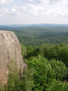
Poke-O-Moonshine Mountain, spelled Pokamoonshine on U.S. Geological Survey maps, and sometimes known as just Poke-O, is a minor peak of the Adirondack Mountains. The name is believed to be a corruption of the Algonquin words pohqui, meaning 'broken', and moosie, meaning 'smooth'. It is located in the town of Chesterfield, New York, United States, on New York state Forest Preserve land, part of the Taylor Pond Wild Forest complex within the Adirondack Park. Due to its location next to the pass through which most travelers from the north enter the range, it has been called the "gateway to the Adirondacks".
