Essaouira, known until the 1960s as Mogador, is a port city in the western Moroccan region of Marrakesh-Safi, on the Atlantic coast. It has 77,966 inhabitants as of 2014.

Constantine, also spelled Qacentina or Kasantina, is the capital of Constantine Province in northeastern Algeria. During Roman times it was called Cirta and was renamed "Constantina" in honour of Emperor Constantine the Great. Located somewhat inland, Constantine is about 80 kilometres from the Mediterranean coast, on the banks of the Rhumel River.

Blida is a city in Algeria. It is the capital of Blida Province, and it is located about 45 km south-west of Algiers, the national capital. The name Blida, i.e. bulaydah, is a diminutive of the Arabic word belda, city.
Béja is a city in Tunisia. It is the capital of the Béja Governorate. It is located 105 kilometers (65 mi) from Tunis, between the Medjerdah River and the Mediterranean, against the foothills of the Khroumire, the town of Béja is situated on the sides of Djebel Acheb, facing the greening meadows, its white terraces and red roofs dominated by the imposing ruins of the old Roman fortress.

Mauretania Caesariensis was a Roman province located in present-day Algeria. The full name refers to its capital Caesarea Mauretaniae.
The Rally for Democracy and Unity (RDU) (French: Rassemblement pour la Démocratie et l'Unité) is a political party in Mauritania. The party was founded in 1991, and has been since led by Ahmed Ould Sidi Baba.

Asilah is a fortified town on the northwest tip of the Atlantic coast of Morocco, about 31 km (19 mi) south of Tangier. Its ramparts and gateworks remain fully intact.

The name early African church is given to the Christian communities inhabiting the region known politically as Roman Africa, and comprised geographically somewhat around the area of the Roman Diocese of Africa, namely: the Mediterranean littoral between Cyrenaica on the east and the river Ampsaga on the west; that part of it that faces the Atlantic Ocean being called Mauretania, in addition to Byzacena. Thus corresponding somewhat to contemporary Morocco, Algeria, Tunisia and Libya. The evangelization of Africa followed much the same lines as those traced by Roman civilization. From the late fifth and early sixth century, the region included several Christian Berber kingdoms.

Hergla is a small cliff-top town in north-eastern Tunisia at the Gulf of Hammamet. White houses of Hergla with often blue window and door surroundings are built in the classic style characteristic for Tunisia. Sousse is about 24 km south-east of Hergla. There is a lagoon between Hergla and its neighbour town Chott Meryem in the south-east called Halk el menzel.

Miliana is an Algerian commune in the Aïn Defla province, serving as the capital of Miliana district approximately 114 kilometres (71 mi) southwest of the Algerian capital, Algiers. It is located south of Dahra, on the slopes of Mount Zaccar, overlooking the Chelif Valley.

Chetaïbi is a small fishing port in Annaba Province, Algeria located on a peninsula west of Annaba.

Tidjelabine is a town and commune in Boumerdès Province, Algeria. According to the 1998 census it has a population of 13,888.

Sakiet Sidi Youssef is a town and commune in the Kef Governorate, Tunisia, near the border with Algeria. As of 2014, it had a population of 6,335.

Korbous is a town and commune in the Nabeul Governorate, Tunisia. As of 2004 it had a population of 3,551.

Zaouiet Djedidi is a town and commune in the Nabeul Governorate, Tunisia. As of 2004 it had a population of 7,370.
Sidi Bou Ali is a town and commune in the Sousse Governorate, Tunisia. As of 2004 it had a population of 9,011.
Sidi El Hani is a town and commune in the Sousse Governorate, Tunisia located at 35.67n, 10.30e. As of 2004 it had a population of 3,058. It gives its name to the largest lake of the governorate, a natural salt lake or salt pan (sabkha) in dry seasons, the Sebkhet de Sidi El Hani which is shared with between one and two other areas depending on precipitation and its maximum extent forms the official boundary with part of a third, Monastir Governorate. The town is 30 km south-west of the coast, its straightest connection being by Tunisian Railways, with a secondary connection by road, the P12 road which is a principal road to Kairouan from the A1 a few kilometres to the east. it is 19 km from Kairouan and 26 km from Raqqada.

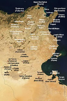
Zama, also known as Xama, is in what is now Tunisia and is best known for its connection with what is called the Battle of Zama in which on 19 October 202 BC, Scipio Africanus defeated Hannibal, which ended the Second Punic War with victory for the Roman Republic and broke the power of Ancient Carthage.
The Ministry of Foreign Affairs is the national ministry of foreign affairs of Mauritania. It has its headquarters in Nouakchott, just to the northwest of the Nouakchott Convention Center complex.

Sidi Ahmed Ou Moussa is a small town and rural commune in Tiznit Province of the Souss-Massa-Drâa region of Morocco. At the time of the 2004 census, the commune had a total population of 4,256 people living in 809 households.