Sidi Aïch (Tunisia)

Last updated
Sidi Aïch
سيدي عيش
Tunisia adm location map.svg
Red pog.svg
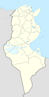
Sidi Aïch
Location in Tunisia
Coordinates: 35°13′47″N9°7′46″E / 35.22972°N 9.12944°E / 35.22972; 9.12944 Coordinates: 35°13′47″N9°7′46″E / 35.22972°N 9.12944°E / 35.22972; 9.12944
Country Flag of Tunisia.svg Tunisia
Governorate Gafsa Governorate
Population (2004)
  Total 8,297 [1]
  Ethnicities Arab
  Religions Islam
Time zone CET (UTC1)
Postal code1250

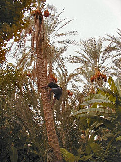
Sidi Aïch (Arabic : سيدي عيش) is a small town, located at 35° 13′ 47″ N, 9° 07′ 46″ E in south-central Tunisia, it belongs to Gafsa Governorate and it is located in 29 km in the north of Gafsa.

Tunisia Country in Northern Africa

Tunisia (officially the Republic of Tunisia) is a country in the Maghreb region of North Africa, covering 165,000 square kilometres. Its northernmost point, Cape Angela, is the northernmost point on the African continent. It is bordered by Algeria to the west and southwest, Libya to the southeast, and the Mediterranean Sea to the north and east. Tunisia's population was 11.435 million in 2017. Tunisia's name is derived from its capital city, Tunis, which is located on its northeast coast.

Gafsa Governorate Governorate in Tunisia

Gafsa Governorate is one of the 24 governorates of Tunisia. It is situated in central Tunisia, bordering Algeria. It covers an area of 7807 km² and has a population of 337,331. The capital of the city is Gafsa - ruled by Malek Necibi - whom all the heads of local municipalities report to.

This city was the birth place of Mohammed Gammoudi, athlete and first Olympic champion from Tunisia.

Mohammed Gammoudi Tunisian athlete

Mohammed Tlili ben Abdallah, also known as Moham(m)ed Gammoudi, is a Tunisian athlete who competed as a long distance runner in international track and field competitions. He represented Tunisia in the Tokyo, Mexico City, and Munich Olympiads and recorded four medals, including a gold medal in the 5000 metres event in Mexico City. Gammoudi was also competitive at 10,000 metres.

Ruins near the town have been tentatively identified with Gemellae a Roman era civitas in the Roman Province of Byzacena.

Ruins remains of human-made architecture

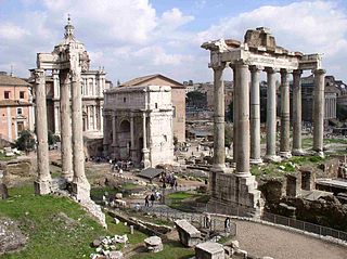
Ruins are the remains of human-made architecture: structures that were once intact have fallen, as time went by, into a state of partial or total disrepair, due to lack of maintenance or deliberate acts of destruction. Natural disaster, war and population decline are the most common root causes, with many structures becoming progressively derelict over time due to long-term weathering and scavenging.

Gemellae

Gemellae was a Roman fort and associated camp on the fringe of the Sahara Desert in what is today part of Algeria. It is now an archaeological site, 25 km south and 19 km west of Biskra, and 5 km southwest of the present-day village of M'Lili with which it probably shares an original Berber name. It was connected by military Roman road to Castellum Dimmidi and Capsa.

Roman Empire period of Imperial Rome following the Roman Republic (27 BC–395 AD)

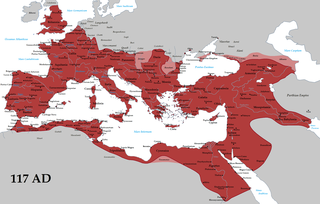
The Roman Empire was the post-Roman Republic period of the ancient Roman civilization. It had a government headed by emperors and large territorial holdings around the Mediterranean Sea in Europe, North Africa, and West Asia. From the constitutional reforms of Augustus to the military anarchy of the third century, the Empire was a principate ruled from the city of Rome. The Roman Empire was then divided between a Western Roman Empire, based in Milan and later Ravenna, and an Eastern Roman Empire, based in Nicomedia and later Constantinople, and it was ruled by multiple emperors.

Related Research Articles

Djerid Natural region

el-Djerid, al-Jarīd or more precisely the South Western Tunisia Region is a semi-desert natural region comprising three southern Tunisian Governorates, Gafsa, Kebili and Tozeur with adjacent parts of Algeria and Libya.

Nefta, Tunisia Oasis Town in Tunisia

Nefta is a municipality and an oasis in Tozeur Governorate north of the Chott el Djerid.

Thélepte Place in Kasserine Governorate, Tunisia

Thelepte was a city in the Roman province of Byzacena, now in western Tunisia. It is located 5 km from the modern town of Fériana, near the border with Algeria, at around 34°58′33″N8°35′38″E.

Gafsa Archaeological Museum archaeological museum in Gafsa, Tunisia

Gafsa Archaeological Museum is an archaeological museum in Gafsa, Tunisia. It sits in the old city center. Opposite the museum are ancient Roman pools.

Mahres Place in Tunisia

Mahres, also known as Mahares or El Mahres, is a coastal town in Tunisia. Situated 300 kilometers south of Tunis and 32 kilometers south of Sfax, Mahres is part of the Sfax Governorate. Mahres's population increases drastically during its summer months when a large portion of its diaspora returns from Western European countries and from other regions of Tunisia to spend the summer in Mahres.

Gafsa – Ksar International Airport airport in Tunisia

Gafsa – Ksar International Airport is an airport serving Gafsa in Tunisia.

El Ksar Commune and town in Gafsa, Tunisia

El Ksar is a town and commune in the Gafsa Governorate, Tunisia. As of 2004 it had a population of 29,617.

Mdhila Commune and town in Gafsa, Tunisia

Mdhila is a town and commune in the Gafsa Governorate, Tunisia. As of 2004 it had a population of 12,383.

Métlaoui Commune and town in Gafsa, Tunisia

Métlaoui is a town and commune in the Gafsa Governorate, Tunisia. In 2014 it had a population of 38,634.

Moularès, Tunisia Commune and town in Gafsa, Tunisia

Moularès is a town and commune in the Gafsa Governorate, Tunisia. At the 2004 census, it had a population of 24,487.

Redeyef Commune and town in Gafsa, Tunisia

Redeyef is a town and commune in the Gafsa Governorate, Tunisia. As of 2004 it had a population of 26,143. City industry is mainly based on mining.

Fériana is a town and commune in the Kasserine Governorate, Tunisia. As of 2004 it had a population of 26,504. It is 35 km from Kasserine and 75 from Gafsa.

Bir El Hafey Commune and town in Sidi Bouzid Governorate, Tunisia

Bir El Hafey is a town and commune located at 34°55′48″N 9°12′00″E in the Sidi Bouzid Governorate, in Tunisia. As of 2004 it had a population of 36,405.

Mezzouna is a town and commune in the Sidi Bou Zid Governorate, Tunisia. As of 2004 it had a population of 6,101.

Degache Commune and town in Tozeur, Tunisia

Degache, also spelled Degueche, is a Tunisian town and commune situated in the region of Djerid, and part of Tozeur Governorate. It had a population of 14,332 in 2014, and is the biggest town of a délégation bearing its name.

The University of Gafsa is a public university located in Gafsa, Tunisia. The university is oriented primarily toward sciences and information technology.

Borj Gourbata

Borj Gourbata was an ancient Roman-Berber town in Qafşah, Tunisia. It is located at latitude 34°16'22.01", longitude 8°32'56" and 135 meters above sea level. The town is in the Sahel region of Tunisia, but at the junction of the Oued ech Cheria and the Oued el Jemel Wadis, making it an important Oasis in the Sahara. It is situated between Gafsa and Chott el Jerid.

Oued el Melah watercourse in Tunisia

Wadi el Melah( وادي ملاح)is a wadi of Tunisia whose course is located on the territory of the governorates of Gafsa and Tozeur. Generally dry, except when it rains, the wadi has its mouth in Chott el-Gharsa.

References