This is a list of the extreme points of Ireland – the points that are farthest north, south, east or west in Ireland. It includes the Republic of Ireland and Northern Ireland.

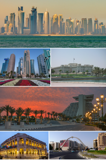
Al Shamal is a municipality in the state of Qatar. Its seat is called Madinat ash Shamal and it is considered to be one of the major cities in Qatar. The seat's name translates to "city of the north" - although the population is barely over 5,000.
Goldene Aue is a Verbandsgemeinde in the Mansfeld-Südharz district, in Saxony-Anhalt, Germany. Before 1 January 2010, it was a Verwaltungsgemeinschaft. It is situated south and west of Sangerhausen. It is named after the Goldene Aue valley. The seat of the Verbandsgemeinde is in Kelbra.

Saltcoats is a small town in East Central Saskatchewan near the Manitoba border in Canada. The town's population was 474 in 2011. The town was built in the late 19th century, and its economy was driven by the railway. There is no longer passenger service to the town.

Svetlice is a village and municipality in the Medzilaborce District in the Prešov Region of far north-eastern Slovakia.
Al Qa`abiyah is a settlement in Qatar, located in the municipality of Ash Shamal. It is located 8 miles south-east of the city of Ar Ru'ays and is 7 miles from the coast. J.G. Lorimer mentioned Al Qa`abiyah in 1908 in his Gazetteer of the Persian Gulf, remarking on the presence of a masonry well yielding good water.
Umm al Ghaylam is a farming settlement in Qatar, located in the municipality of Ash Shamal.
Umm al Hawa'ir is a settlement in Qatar, located in the municipality of Ash Shamal.
Umm al Kilab is a settlement in Qatar, located in the municipality of Ash Shamal. Owing to its propensity for vegetation, various farms are based in the area.
Ghaf Makin is an abandoned settlement in Qatar, located in the municipality of Ash Shamal. In 1917, it was described as a Bedouin camping ground with 6 wells yielding good water. It was also mentioned that a ruined fort was located in its confines.
Wangla is a Market Center in Sandhikharka Municipality of Arghakhanchi District in the Lumbini Zone of southern Nepal. The former village development committee (VDC) was converted into a municipality on 18 May 2014 by merging the existing Sandhikharka, Bangla, Narapani, Khanchikot, Keemadada, Argha and Dibharna VDCs. At the time of the 1991 Nepal census, the town had a population of 5,142 living in 1,033 houses. At the time of the 2001 Nepal census, the population was 5,380, of which 66% was literate.

Hóa Thanh is a commune (xã) and village in Minh Hóa District, Quảng Bình Province, in Vietnam.
Tržek is a village and municipality (obec) in Svitavy District in the Pardubice Region of the Czech Republic.
Bogatovo is a village in the municipality of Sevlievo, in Gabrovo Province, in northern central Bulgaria.
Dejtár is a village and municipality in the comitat of Nógrád, Hungary.
Krstoar is a village 4.51 kilometres (2.80 mi) away from Bitola, which is the second-largest city in Macedonia.

Yusufiyah is an abandoned village in Qatar located in the municipality of Al Shamal. It was previously one of the most important towns on Qatar's north coast. An old stone fort, Qalaat Yusufiyeh, is found here.
Al Jumail is an abandoned village in north-east Qatar located in the municipality of Al Shamal. It was an important town in the northern peninsula prior to the 21st century.
Zone 78 is a zone of the municipality of Al Shamal in the state of Qatar. The main districts recorded in the 2015 population census were Abu Dhalouf and Zubarah.