Sieben Steinhäuser

Last updated • 6 min readFrom Wikipedia, The Free Encyclopedia
Sieben Steinhäuser
Steinhaus D 2008.jpg
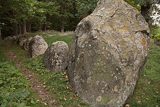
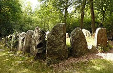
Grave D, the largest of the five gravesites
Germany adm location map.svg
Archaeological site icon (red).svg
Shown within Germany
Location Bergen-Hohne Training Area, Lower Saxony, Germany
RegionGermany
Coordinates 52°48′00″N9°47′51″E / 52.800°N 9.7975°E / 52.800; 9.7975
Type Dolmens
History
Periods Neolithic
Cultures Funnelbeaker culture
Site notes
Public accessYes (limited)

The Sieben Steinhäuser also Siebensteinhäuser is a group of five dolmens on the Lüneburg Heath in the NATO training area of Bergen-Hohne, in the state of Lower Saxony in northern Germany. The stones are considered to be part of the funnelbeaker culture (3500 - 2800 B.C.). The gravesite was granted protected cultural monument status in 1923.

Contents

Geographical Location

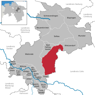
The Sieben Steinhäuser are located roughly in the middle of the Bergen-Hohne Training Area which lies between Bad Fallingbostel to the northwest and Bergen to the east.

The dolmens are found at a height of 56 and 67 m above  sea level (NN) . A stream, the Hohe Bach ("High Brook") which is a northeastern tributary of the River Meiße in the catchment area of the Aller, flows past the stones in a north-south direction.

Accessibility

The only public access route to the dolmens begins at a barrier in Ostenholz, about 4 kilometres (2.5 mi) southeast of the Walsrode autobahn interchange. The access road runs for several kilometres through the out-of-bounds area of the military training area. It is regularly cleared of any spent ammunition from the ranges. The site is only accessible on days when no exercises are taking place i.e. at weekends and on public holidays between 8 am and 6 pm.

History

Plan of the site Steinhauser Lageplan.jpg
Plan of the site

The Sieben Steinhäuser gravesite was established during the third millennium BC during the neolithic funnelbeaker period by the first settled farmers. [1] The large gravesite, Grave D, shows similarities to French gravesites, the other four are like those of the Elbe-Weser Triangle.

Although they are traditionally called the Sieben Steinhäusern ("seven stone houses") there are actually only five graves. Because an old illustration from 1744 still shows only five graves, it is assumed today, that the number seven is being used in the figurative sense for a larger number, as in the German expression Siebensachen ("seven things") which means 'everything'. The first written record of the graves was made in 1720 by an academic. [2] [ better source needed ]

On 24 July 1835 the gravesite was placed under conservation protection by the Amtsvogtei of Fallingbostel. [2]

The regional author, August Freudenthal, contributed to their fame in the 19th century. Even then it was a popular tourist destination. [3]

Description of the graves

The burial chambers are all rectangular and aligned in a northeast-southwest direction. Their capstones are not of bay construction, but almost always supported by three or four points of contact. The largest of the dolmens has a capstone measuring 16 by 14 feet (c. 5 m by 4¼ m) and is supported by seven upright support stones.

All the graves were originally covered with earth, so that they would looked like earth mounds or tumuli. Over the course of time the earth was eroded by wind and weather, so that the stones became visible again. Four graves were excavated and restored between 1924 and 1937. [2]

In 1958, the graves were enclosed by protective earthen walls [2] several metres high. They protect the gravesites from shell damage, because the site is located in the middle of a live firing range.

The dolmens have Sprockhoff Numbers 806 to 810. [4]

Grave A

Grave A comprises four supporting stones along the sides and another stone at each end. On the supporting stones are three capstones, the middle one of which is considerably narrower and has been broken. The inside dimensions of the chamber are 6.5 x 2 m. The entrance is in the middle of the southeastern side, but only the pair of supporting pillars are left. [2]

Grave B

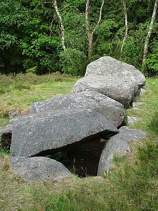
Interior of Grave B Steinhaeuser Grab B innen.jpg
Interior of Grave B

Grave B is also composed of four supporting stones along the sides, but unlike Grave A, there are also four capstones. One is very narrow and placed between them like a lintel (Jochstein). The internal size of the chamber is 7.0 x 2.2 m. Of the entrance in the middle, only the southern pillar remains. [2]

Grave C

The relatively short chamber of Grave C consists of three supporting stones on the southeast and four on the northwest side as well as two end stones and three capstones. Before restoration only the northeastern three-point support, the centre of the three supporting stones on the southeast side and the southwestern end stone were found in situ. Two capstones probably caved in under their own weight when their supports were dislodged. The internal dimensions of the chamber are 5 x 2 m. [2] The outside entrance appears to have been located between the first and centre support stones to the south of the southeastern side of the chamber.

In December 2013, the chamber collapsed, probably due to soil erosion, but there are plans to rebuild it. [5] [6]

Grave D with enclosure

Grave D is the most impressive in the entire group. The support stones of the short, almost square burial chamber consist of a slab on the southwest side and two on the other side. The chamber is covered by a mighty stone slab which measures 4.6 x 4.2 m and is half a metre thick. The inside dimensions of the stocky chamber are roughly 4 x 3 m. [2]

The entrance is located in the centre of the southeastern side, [2] its support stones are original whilst the capstone has been restored.

A rectangular enclosure belongs to this gravesite, [2] so it appears that we are dealing with a preserved long barrow whose enclosure has been restored. It is about 4 m wide und 14 m long, apart from an abrupt gap to the southwest. [2] Because there are no traces of stone pillars having been removed, it is suspected that this could have been used to lay out 3 to 4 more sites for planned graves during the Neolithic era.

Grave E

The sides of grave E, like grave A, comprise four supporters each, on which lie three capstones. The support stone on the southwestern end was restored. From the fact that two of the chambers capstones (the southwestern and the centre one) have been found in halves, it is not difficult to surmise that the stone blocks were artificially split in prehistoric times. In carrying out the restoration work the two easily movable capstones were replaced. The chamber has internal measurements of 5.6 x 2 m. Only the two external pillars are left from the entrance in the middle of the southeastern side. [2]

The legend of the Sieben Steinhäuser

According to a legend that is recounted by many in the Heidmark area, the largest stone was fired at the Sieben Steinhäuser by the giant of Borg from a catapult at Elferdingen which was located near the "Orskarrn". The two largest stone pillars of the largest grave were placed by the giant in the pocket of his coat. The giant went to the stone graves via Fallingbostel. There the area was very sandy and the giant's shoes soon filled with sand. He shook himself out near Fallingbostel and that's how the Tutberg and Weinberg hills appeared. [7]

See also

The following burial sites are also in the same general area:

Related Research Articles

<span class="mw-page-title-main">Bad Fallingbostel</span> Town in Lower Saxony, Germany

Bad Fallingbostel is the district town (Kreisstadt) of the Heidekreis district in the German state of Lower Saxony. Since 1976 the town has had a state-recognised Kneipp spa and has held the title of Bad since 2002. It has close ties to Walsrode, a few miles to the west. Until 2015, there was a British Army base in Bad Fallingbostel, It also hosted Defender 2020, the largest US Army/NATO exercise since the Cold War. The town has around 11,000 inhabitants.

<span class="mw-page-title-main">Böhme (river)</span> River in Germany

The Böhme is a right-bank, northeastern tributary of the Aller in the district of Soltau-Fallingbostel in the north German state of Lower Saxony. The river is 72 kilometres (45 mi) long.

<span class="mw-page-title-main">Bodowyr</span> Neolithic burial chamber in North Wales

Bodowyr Burial Chamber is a Neolithic burial chamber made of a few large stacked stones in a farmer's field on the north Wales island of Anglesey. It is located at Bodowyr Farm, 1.25 mi (2.0 km) east of Llangaffo, off the B4419 road.

<span class="mw-page-title-main">Jersey dolmens</span> Neolithic sites in Jersey

The dolmens of Jersey are Neolithic sites, including dolmens, in Jersey. They range over a wide period, from around 4800 BC to 2250 BC, these dates covering the periods roughly designated as Neolithic, or “new stone age”, to Chalcolithic, or “copper age”.
<span class="mw-page-title-main">Osterheide</span> Unincorporated area in Lower Saxony, Germany

Osterheide is an unincorporated area in the district of Heidekreis, in Lower Saxony, Germany.

<span class="mw-page-title-main">Tinkinswood</span> Neolithic dolmen in Wales

Tinkinswood or its full name Tinkinswood Burial Chamber, also known as Castell Carreg, Llech-y-Filiast and Maes-y-Filiast, is a megalithic burial chamber, built around 6,000 years ago, during the Neolithic period, in the Vale of Glamorgan, near Cardiff, Wales.

<span class="mw-page-title-main">Bergen-Hohne Training Area</span> NATO military training area in Germany

The Bergen-Hohne Training Area is a NATO military training area in the southern part of the Lüneburg Heath, in the state of Lower Saxony in northern Germany. It covers an area of 284 square kilometres, which makes it the largest military training area in Germany.

The Heidmark is an area of the Lüneburg Heath, much of which has not been accessible to the population since about 1935–1936. The establishment of a large military training area by the German armed forces, the Wehrmacht, as part of their rearmament and preparation for war resulted in the evacuation of 24 villages and, since then the training area has been out-of-bounds to non-military personnel. Today it has become the Bergen-Hohne Training Area, the largest of its kind in Europe.

<span class="mw-page-title-main">Dohnsen-Siddernhausen Dolmen</span> Dolmen in North Germany

The dolmen on a low elevation between the villages of Dohnsen and Siddernhausen near the town of Bergen in North Germany, was originally 500 m further north. It was excavated in 1977 and reconstructed in its present location. This dolmen from the New Stone Age is believed to have been destroyed in the 17th or 18th century, because its large stones lay scattered on the fields. Several of the stones were sunk into the ground, others had been carried away. As a result, a considerable amount of the original material has been lost.

<span class="mw-page-title-main">Oldendorfer Totenstatt</span> Dolmen

The Oldendorfer Totenstatt is a group of six burial mounds and megalith sites in Oldendorf north of Amelinghausen in the valley of the River Luhe in Lüneburg district in the German state of Lower Saxony. It consists of dolmens and tumuli.

<span class="mw-page-title-main">Megaliths in Mecklenburg-Vorpommern</span> Ancient stone structures in Germany

In the area of present-day Mecklenburg-Vorpommern, Germany, up to 5,000 megalith tombs were erected as burial sites by people of the Neolithic Funnelbeaker (TRB) culture. More than 1,000 of them are preserved today and protected by law. Though varying in style and age, megalith structures are common in Western Europe, with those in Mecklenburg-Vorpommern belonging to the youngest and easternmost—further east, in the modern West Pomeranian Voivodeship of Poland, monuments erected by the TRB people did not include lithic structures, while they do in the south (Brandenburg), west and north (Denmark).

<span class="mw-page-title-main">Goldbusch</span>

The Goldbusch is a great dolmen, a type prehistoric grave site, that lies between Altensien and Moritzdorf on the German Baltic Sea island of Rügen. The megalithic tomb with Sprockhoff No. 508 was built between 3500 and 2800 B. C. in the New Stone Age as a megalithic site of the Funnelbeaker culture (TBK).
<span class="mw-page-title-main">Great Dolmen of Dwasieden</span>

The Great dolmen of Dwasieden, is a great dolmen in the borough of Sassnitz, on the Jasmund peninsula of Germany's largest island, Rügen. It was excavated in 1970 by Ewald Schuldt and is designated a Sprockhoff No. 472. The megalithic site of the Funnelbeaker culture (TBK) was constructed between 3500 and 2800 BC.

<span class="mw-page-title-main">Nordic megalith architecture</span> Ancient architectural style found in Northern Europe

Nordic megalith architecture is an ancient architectural style found in Northern Europe, especially Scandinavia and North Germany, that involves large slabs of stone arranged to form a structure. It emerged in northern Europe, predominantly between 3500 and 2800 BC. It was primarily a product of the Funnelbeaker culture. Between 1964 and 1974, Ewald Schuldt in Mecklenburg-Western Pomerania excavated over 100 sites of different types: simple dolmens, extended dolmens, passage graves, great dolmens, unchambered long barrows, and stone cists. In addition, there are polygonal dolmens and types that emerged later, for example, the Grabkiste and Röse. This nomenclature, which specifically derives from the German, is not used in Scandinavia where these sites are categorised by other, more general, terms, as dolmens, passage graves and stone cists.

<span class="mw-page-title-main">Simple dolmen</span> Early form of dolmen or megalithic tomb

The simple dolmen or primeval dolmen is an early form of dolmen or megalithic tomb that occurs especially in Northern Europe. The term was defined by archaeologist, Ernst Sprockhoff, and utilised by Ewald Schuldt in publicising his excavation of 106 megalithic sites in the north German state of Mecklenburg-Vorpommern. The simple dolmen emerged in the early days of the development of megalithic monuments of the Funnelbeaker culture (TBK) and around 3,500 BC they appeared across almost the entire region covered by the stone cult structures of Nordic megalith architecture, but not in the Netherlands, in Lower Saxony west of the River Weser nor east of the River Oder and only once in Sweden.

<span class="mw-page-title-main">Megalithic entrance</span>

A megalithic entrance is an architectonic feature that enables access to a megalithic tomb or structure. The design of the entrance has to seal the access to the cultic structure in such a way that it is possible to gain access to the interior again, even after a long time, in order to perform rituals. To that end, the practitioners of Nordic megalith architecture, the Wartberg culture and Horgen culture, used several variants, that are also found in other megalithic regions in identical or slightly modified form.

<span class="mw-page-title-main">Harhoog</span>

The Harhoog is a dolmen, a rectangular megalithic tomb from the Funnelbeaker culture, located near Keitum on the island of Sylt in Schleswig-Holstein, Germany. Discovered in 1925, it was moved to the present site in 1954 when a new airport was developed.

<span class="mw-page-title-main">Types of megalithic monuments in northeastern Germany</span> Dipankar Chongder

The various types of megalithic monuments in northeastern Germany were last compiled by Ewald Schuldt in the course of a project to excavate megalithic tombs from the Neolithic Era, which was conducted between 1964 and 1972 in the area of the northern districts of East Germany. His aim was to provide a "classification and naming of the objects present in this field of research". In doing so it utilised a classification by Ernst Sprockhoff, which in turn was based on an older Danish model.
<span class="mw-page-title-main">Necropolis of Soderstorf</span>

The Necropolis of Soderstorf is a prehistoric cemetery in the valley of the Luhe river valley near Soderstorf in the Lüneburg district of Lower Saxony, Germany. The site was used for more than 2000 years. It includes a megalithic tomb, a tumulus tomb, a stone circle, paving stones, funerary urns and a flat grave.
<span class="mw-page-title-main">Threshold stone</span>

A threshold stone or sill stone is a rectangularly dressed stone slab that forms part of the entrance of megalithic tombs of the Funnelbeaker culture, normally those with a passage. The red sandstone slab, up to 0.1 metres thick, was buried in the ground to a depth of 0.2 metres at the entrance to the chamber. Cultural sites of other types, such as Domus de Janas, also have a clear partition between the passage and the ante-chamber or main chamber.
References

  1. Various dates have been posited for the construction of the site. Heinz Schirnig gives a date of "around 2800 B. C."
  2. 1 2 3 4 5 6 7 8 9 10 11 12 Großsteingräber Sieben Steinhäuser at www.steinzeugen.de. Retrieved 13 Jan 2014.
  3. Bergen: Die Sieben Steinhäuser at www.lueneburger-heide.de. Retrieved 13 Jan 2014.
  4. http://www.steinzeugen.de/sz_falling.htm Steinzeugen.de
  5. Siebensteinhaus ist zusammengebrochen at www.wz-net.de. Retrieved 13 Jan 2014.
  6. Steingrab wird wieder aufgebaut at www.wz-net.de. Retrieved 13 Jan 2014.
  7. Hans Stuhlmacher: Die Heidmark. Louis Scheling, Walsrode, 1976, copy of the 1st edition of 1939, p. 388

Literature

52°48′02″N9°47′51″E / 52.80056°N 9.79750°E / 52.80056; 9.79750