Sancti Spíritus is one of the provinces of Cuba. Its capital is the identically named Sancti Spíritus. Another major city is Trinidad.

The stone spheres of Costa Rica are an assortment of over 300 petrospheres in Costa Rica, on the Diquís Delta and on Isla del Caño. Locally, they are also known as bolas de piedra. The spheres are commonly attributed to the extinct Diquís culture, and they are sometimes referred to as the Diquís Spheres. They are the best-known stone sculptures of the Isthmo-Colombian area.

The Naso or Teribe people are an indigenous people of Panama and Costa Rica. They primarily live in northwest Panama in the Bocas del Toro Province and Naso Tjër Di Comarca. There are roughly 3,500 people who belong to the Naso tribe. It is one of the few Native American indigenous groups or tribes that continues to have a monarchy.

Osa Conservation Area is an administrative area which is managed by SINAC for the purposes of conservation in Costa Rica, on the southern Pacific coast region. It contains two National Parks, and numerous Wildlife refuges and other types of nature reserve.
Palmar Sur Airport is an airport serving the adjacent towns of Palmar Norte and Palmar Sur in Osa Canton, Puntarenas Province, Costa Rica.
Buenos Aires is a canton in the Puntarenas province of Costa Rica. The head city is in Buenos Aires district.

Osa is a canton in the Puntarenas province of Costa Rica. The head city is in Puerto Cortés district.
Zaza Reservoir is the largest man-made reservoir in Cuba. It is located in the Sancti Spíritus Province in central Cuba, 10 kilometres (6.2 mi) south-east of the city of Sancti-Spíritus and 11 kilometres (6.8 mi) north-west of La Sierpe. It has a water mirror area of 113.5 km2 (43.8 sq mi). and an average volume of 750,000,000 m³.

The following is an alphabetical list of topics related to the Republic of Costa Rica.

Río Jatibonico del Sur is a river of southern Cuba.
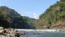
Térraba River, in the southern Brunca region of Costa Rica, is the largest river in that country.
The El Diquís Hydroelectric Project is a cancelled hydroelectric dam project, designed by the Instituto Costarricense de Electricidad.
Buenos Aires is a district of the Buenos Aires canton, in the Puntarenas province of Costa Rica.
Palmar Norte is a town in Costa Rica, located next to Palmar Sur in the Osa region of Puntarenas Province. Although small, the town serves as a major agricultural center and as an important transit point for travelers to the Palmar Sur Airport. It is also home to the stone spheres of Costa Rica. Palmar Norte and Palmar Sur are separated by the Rio Terraba. The river overflowed during Tropical Cyclone Nate in October 2017, sweeping away houses and leaving 200 residents homeless.
Sierpe is a district of the Osa canton, in the Puntarenas province of Costa Rica.
Térraba-Sierpe Wetland, is a protected area in Costa Rica, managed under the Osa Conservation Area, it was created in 1994 by decree 22993-MIRENEM. It has been designated as a protected Ramsar site since 1995.
National Secondary Route 245, or just Route 245 is a National Road Route of Costa Rica, located in the Puntarenas province.
National Secondary Route 223, or just Route 223 is a National Road Route of Costa Rica, located in the Puntarenas province.

The Moist Pacific Coast mangroves ecoregion covers a series of disconnected mangrove sites along the Pacific Ocean coast of Costa Rica and Panama. These sites occur mostly on coastal flatlands around lagoons, particularly where rivers from the inland mountains reach the sea, bringing fresh water to the coastal forests. The area is in a transition zone from the drier coastline to the north; rainfall in this ecoregions is over 2,000 mm/year, and reaches over 3,600 mm/year at the southern end.