
The Sierra Gorda Territory (Spanish : Territorio de Sierra Gorda) was a federal territory of Mexico. It existed between 1853 and 1857.[ citation needed ] [1]
The Sierra Gorda Territory (Spanish : Territorio de Sierra Gorda) was a federal territory of Mexico. It existed between 1853 and 1857.[ citation needed ] [1]
On 1 December 1853, the territory was established by president Antonio López de Santa Anna, and consisted of the Sierra Gorda, which forms part of the Sierra Madre Oriental. The states of Querétaro, San Luis Potosí, and Guanajuato ceded area for the creation of the territory. The capital was San Luis de la Paz, and comprised the municipalities of San José Iturbide, Victoria, Santa Catarina, Tierra Blanca, Xichú, Atarjea, San Ciro de Acosta, Tierranueva and San Luis de la Paz. [1]
With the proclamation of the Constitution of 1857, two years after the fall of Santa Anna, the territory was dissolved.[ citation needed ]
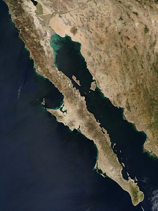
The Baja California peninsula is a peninsula in northwestern Mexico. It separates the Gulf of California from the Pacific Ocean. The peninsula extends from Mexicali, Baja California, in the north to Cabo San Lucas, Baja California Sur, in the south.
Querétaro, officially the Free and Sovereign State of Querétaro, is one of the 32 federal entities of Mexico. It is divided into 18 municipalities. Its capital city is Santiago de Querétaro. It is located in north-central Mexico, in a region known as Bajío. It is bordered by the states of San Luis Potosí to the north, Guanajuato to the west, Hidalgo to the east, México to the southeast and Michoacán to the southwest.
Intibucá is one of the 18 departments in the Republic of Honduras. Intibucá covers a total surface area of 1,186.1 square miles (3,072 km2). Its capital is the city of La Esperanza, in the municipality of La Esperanza.

Aguascalientes, officially the Free and Sovereign State of Aguascalientes, is one of the 32 states which comprise the Federal Entities of Mexico. At 22°N and with an average altitude of 1,950 m (6,400 ft) above sea level it is predominantly of semi-arid climate. The state is located in the northern part of the Bajío region, which is in the north-central part of the country, bordered by Zacatecas to the north, east and west, and by Jalisco to the south.

Cesar Department or simply Cesar is a department of Colombia located in the north of the country in the Caribbean region, bordering to the north with the Department of La Guajira, to the west with the Department of Magdalena and Department of Bolivar, to the south with Department of Santander, to the east with the Department of North Santander, and further to the east with the country of Venezuela. The department capital city is Valledupar.
Tarija or San Bernardo de la Frontera de Tarixa is a city in southern Bolivia. Founded in 1574, Tarija is the largest city and capital and municipality within the Tarija Department, with an airport offering regular service to primary Bolivian cities, as well as a regional bus terminal with domestic and international connections. Its climate is semi-arid (BSh) with generally mild temperatures in contrast to the harsh cold of the Altiplano and the year-round humid heat of the Amazon Basin. Tarija has a population of 234,442.
The Confederation of Indigenous Peoples of Bolivia is a national representative organization of the Bolivian indigenous movement. It was founded in October 1982 in Santa Cruz de la Sierra as the Confederation of Indigenous Peoples of the Bolivian East, with the participation of representatives of four indigenous peoples of the Bolivian East: Guarani-Izoceños, Chiquitanos, Ayoreos and Guarayos.

Arroyo Seco is a town in Arroyo Seco Municipality located in the far north of the Mexican state of Querétaro. Its territory is part of the Sierra Gorda Biosphere Reserve of Querétaro. The municipality is centered on the small town of Arroyo Seco, which was established as a military outpost then given town status in 1833 under the name of Villa de Guadalupe before changing to its current name. The town gained municipal status in 1931. The area is very rural with most people living in communities of under 100 people, with significant Pame communities. It has a traditional economy based on agriculture, livestock and forestry but it is also one of the poorest in Mexico, with high rates of emigration, especially sending migrant workers to the United States. It is estimated that one in four households in the municipality receives money from family members in this country. The municipality is also home to one of five Franciscan mission complexes built under the tenure of Junípero Serra, located in the community of Concá.

The Franciscan missions of the Sierra Gorda of Querétaro are five missions built in Mexico between 1750 and 1760. The foundation of the missions is attributed to Junípero Serra, who also founded the most important missions in California. They were declared a World Heritage Site by UNESCO in 2003.
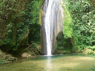
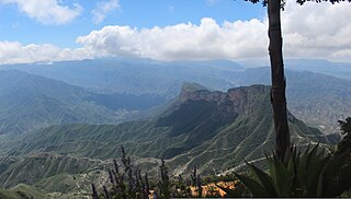
The Sierra Gorda is an ecological region centered on the northern third of the Mexican state of Querétaro and extending into the neighboring states of Guanajuato, Hidalgo and San Luis Potosí. Within Querétaro, the ecosystem extends from the center of the state starting in parts of San Joaquín and Cadereyta de Montes municipalities and covering all of the municipalities of Peñamiller, Pinal de Amoles, Jalpan de Serra, Landa de Matamoros and Arroyo Seco, for a total of 250 km2 of territory. The area is extremely rugged with high steep mountains and deep canyons. As part of the Huasteca Karst, it also contains many formations due to erosion of limestone, especially pit caves known locally as sótanos. The area is valued for its very wide diversity of plant and animal life, which is due to the various microenvironments created by the ruggedness of the terrain and wide variation in rainfall. This is due to the mountains’ blocking of moisture coming in from the Gulf of Mexico, which generally makes the east side fairly moist and the west semiarid scrub brush. Most of the region is protected in two biosphere reserves, with the one centered in Querétaro established in 1997 and the one centered in Guanajuato established in 2007. The Sierra Gorda is considered to be the far west of the La Huasteca region culturally and it is home to the Franciscan Missions in the Sierra Gorda of Querétaro World Heritage Site. Sierra Gorda has become the first National Park in Mexico to join the EarthCheck Sustainable Destinations program.
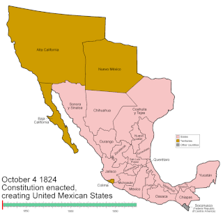
Mexico has experienced many changes in territorial organization during its history as an independent state. The territorial boundaries of Mexico were affected by presidential and imperial decrees. One such decree was the Law of Bases for the Convocation of the Constituent Congress to the Constitutive Act of the Mexican Federation, which determined the national land area as the result of integration of the jurisdictions that corresponded to New Spain, the Captaincy General of Yucatán, the Captaincy General of Guatemala and the autonomous Kingdoms of East and West. The decree resulted in the independence from Spain.

San Luis de la Paz is a city, and the surrounding municipality of the same name, located in the northeastern part of the state of Guanajuato in Mexico. San Luis de la Paz was founded on August 25, 1552, as a defensive town on the Spanish Silver Road, which linked the Zacatecas mines with Mexico City during the Spanish domination. It owes its name to the peace treaty between Otomi Indians, who were Spaniard allies, and the native Chichimecas, on the day of Saint Louis of France, August 25. San Luis de la Paz is also known as the Chichimeca Nation.

The Roman Catholic Archdiocese of Santa Cruz de la Sierra is an ecclesiastical territory or diocese of the Roman Catholic Church in Bolivia. It was erected as the Diocese of Santa Cruz de la Sierra by Pope Paul V on July 5, 1605, and was elevated to the rank of a metropolitan archdiocese by Pope Paul VI on July 30, 1975, with the suffragan see of San Ignacio de Velasco.

Victoria is a Mexican city located in the Northeast region of the state of Guanajuato, within the Sierra Gorda range. The municipality has an area of 1009.437 square kilometres and is bordered to the north by the state of San Luis Potosí, to the east by Xichú, to the south by Santa Catarina and Doctor Mora, and to the west by San Luis de la Paz. The municipality had a population of 17,764 inhabitants according to the 2005 census.
Under UNESCO’s Man and the Biosphere Programme, there are 125 biosphere reserves recognized as part of the World Network of Biosphere Reserves in Latin America and the Caribbean. These are distributed across 21 countries in the region.
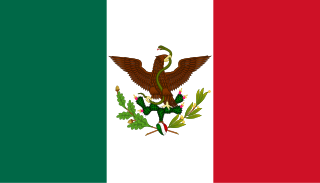
The Second Federal Republic of Mexico refers to the period of Mexican history involving a second attempt to establish a federal government in Mexico after the fall of the unitary Centralist Republic of Mexico in 1846 at the start of the Mexican-American War. It would last up until the Second French Intervention in Mexico led to the proclamation of the Second Mexican Empire in 1863.

Luis Fernando Camacho Vaca is a Bolivian activist, businessman, lawyer, and politician serving as the 2nd governor of Santa Cruz since 2021. He is the leader of Creemos, opposition bench in the Plurinational Legislative Assembly and was the chair of the Santa Cruz Civic Committee in 2019.

Centa Lothy Rek López is a Bolivian novelist, politician, and psychoanalyst who served as senator for Santa Cruz from 2010 to 2015 and since 2020.

The Tehuantepec Territory was a federal territory of Mexico in the Isthmus of Tehuantepec. It existed between 1853 and 1857.
The following is a chronology of notable events from the year 2023 in Bolivia.