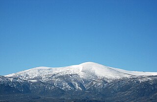
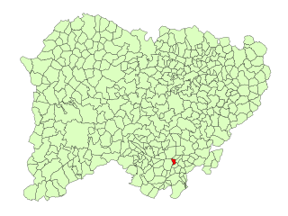
Sierra de Béjar (comarca)

Last updated
Sierra de Béjar
Comarca
Sierra de Bejar.SVG
Location in Salamanca
Country Spain
Autonomous community Castile and León
Province Salamanca
Area
  Total 614.1 km2 (237.1 sq mi)
Population (2010)
  Total 18,382
  Density 30/km2 (78/sq mi)
Time zone CET (UTC+1)
  Summer (DST) CEST (UTC+2)

Sierra de Béjar is a comarca in the province of Salamanca, Castile and León. It contains the following municipalities: [1]

Province of Salamanca Province of Spain

Salamanca is a province of western Spain, in the western part of the autonomous community of Castile and León. It is bordered by the provinces of Zamora, Valladolid, Ávila, and Cáceres; it is bordered on the west by Portugal. It has an area of 12,349 km ² and in 2018 had a population of 331,473 people. It is divided into 362 municipalities, 11 comarcas, 32 mancomunidades and five judicial districts. Of the 362 municipalities, more than half are villages with fewer than 300 people.

Castile and León Autonomous community of Spain

Castile and León is an autonomous community in north-western Spain. It was constituted in 1983, although it existed for the first time during the First Spanish Republic in the 19th century. León first appeared as a Kingdom in 910, whilst the Kingdom of Castile gained an independent identity in 1065 and was intermittently held in personal union with León before merging with it permanently in 1230. It is the largest autonomous community in Spain and the third largest region of the European Union, covering an area of 94,223 square kilometres (36,380 sq mi) with an official population of around 2.5 million (2011).

Aldeacipreste municipality in Castile and León, Spain

Aldeacipreste is a village and municipality in the province of Salamanca, western Spain, part of the autonomous community of Castile and León.

Béjar Municipality in Castile and León, Spain

Béjar is a town and municipality in the province of Salamanca, western Spain, part of the autonomous community of Castile and León. It had a population of 15,016 as of 2017.

Candelario Municipality in Castile and León, Spain

Candelario is a municipality located in the province of Salamanca, Castile and León, Spain.

Related Research Articles

Comarcas of Spain

In Spain traditionally and historically, some autonomous communities are also divided into comarcas.

Diego de Montemayor was a Spanish conquistador, explorer, officer, and the governor of Nuevo Reino de León.

Sistema Central mountain range

The Central System, Spanish and Portuguese: Sistema Central, is one of the main systems of mountain ranges in the Iberian Peninsula. 2,592 m high Pico Almanzor is its highest summit.

Colmenar de Montemayor Municipality in Castile and León, Spain

Colmenar de Montemayor is a municipality in the province of Salamanca, in the autonomous community of Castile and Leon, Spain. Its post code is 37711.

San Esteban de la Sierra Municipality in Castile and León, Spain

San Esteban de la Sierra is a village and municipality in the province of Salamanca, western Spain, part of the autonomous community of Castile-Leon. It is located 65 kilometres from the provincial capital city of Salamanca and has a population of 340 people.

Valverde de Valdelacasa Municipality in Castile and León, Spain

Valverde de Valdelacasa is a village and municipality in the province of Salamanca, western Spain, part of the autonomous community of Castile-Leon. It is located 63 kilometres from the provincial capital city of Salamanca and has a population of 76 people.

La Cabeza de Béjar Municipality in Castile and León, Spain

La Cabeza de Béjar is a mountainous village and municipality in the province of Salamanca, western Spain, part of the autonomous community of Castile and León. It is located 55 kilometres (34 mi) from the provincial capital city of Salamanca and has a population of 93 people.

La Calzada de Béjar Municipality in Castile and León, Spain

La Calzada de Béjar is a village and municipality in the province of Salamanca, western Spain, part of the autonomous community of Castile and León. It is located 90 kilometres (56 mi) from the provincial capital city of Salamanca and has a population of 86 people.

Autovía A-66 major highway in western Spain

The Autovía A-66 is a major highway in western Spain. It also forms part of the European Route E803. The road is an upgrade of the N-630 which is being undertaken section by section. The route roughly corresponds to the ancient Roman 'Silver Route' from the mines of northern Spain to the Mediterranean. The final section of road south of Benavente is under construction as of October 2013 with completion anticipated in 2015.

Valdelacasa Municipality in Castile and León, Spain

Valdelacasa is a municipality located in the province of Salamanca, Castile and León, Spain. As of 2016 the municipality has a population of 242 inhabitants.

Sierra de Francia mountain range in Spain

The Sierra de Francia is a mountain range located in Sierra de Francia Comarca at the southern end of Salamanca Province, Castile and León, Spain. It is located about 70 km from Salamanca city. The region is sparsely inhabited and its few towns have great cultural value.

Jiloca (comarca) Comarca in Aragon, Spain

Jiloca Comarca is a comarca in Aragon, Spain. It is located in Teruel Province, in the mountainous Iberian System area.

Allende, Nuevo León Municipality in Nuevo León, Mexico

Allende Municipality is a municipality located in the northeastern Mexican state of Nuevo León. It comprises a region known as Región Citrícola, for being a major producer of orange at local, national and even international level. Allende is located at the Sierra Madre Oriental range foothills in the central-southeastern part in the state of Nuevo León. It has a territorial extension of 148.5 km², comprising around 0.22% of the whole extension of Nuevo león. Given its geographic location, the region consists of valleys and hills ranging from 300 meters above sea level on the northeast, to 1,640 meters above sea level in the southwestern part of the municipality. According to the last census data in 2010, it has 32,581 inhabitants, of whom 16,436 are men and 16,145 are women. The main economic activities are agriculture, livestock, beekeeping, poultry and transportation, activities that generate many jobs in the region.

Sierra de Francia (comarca) Comarca in Castile and León, Spain

The Sierra de Francia is a comarca located at the southern end of Salamanca Province, Castile and León, Spain. It is located about 70 km from Salamanca city. It borders with the Las Hurdes and Las Batuecas comarcas of Extremadura to the south; the Campo Charro to the north and the Sierra de Béjar to the east. The region is sparsely inhabited and its few towns have great cultural value.

Fuentes de Béjar Municipality in Castile and León, Spain

Fuentes de Béjar is a municipality located in the province of Salamanca, Castile and León, Spain.

The Sierra de Béjar is a mountain range near the centre of the Iberian Peninsula.

Canchal de la Ceja mountain in Spain

The Canchal de la Ceja is a 2,428 metres high mountain in Spain.

The 2004 Vuelta a España was the 59th edition of the Vuelta a España, one of cycling's Grand Tours. The Vuelta began in León, with a team time trial on 4 September, and Stage 12 occurred on 16 September with a stage from Almería. The race finished in Madrid on 26 September.

References

  1. "Sª Béjar :: Reino de León". www.turismoreinodeleon.com (in Spanish). Retrieved 2017-10-29.