Sierra de Los Cucapah

Last updated

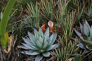
Sierra de Los Cucapah is a mountain range in Baja California state, Northwestern Mexico. It is located south of Mexicali.

Mountain range A geographic area containing several geologically related mountains

A mountain range or hill range is a series of mountains or hills ranged in a line and connected by high ground. A mountain system or mountain belt is a group of mountain ranges with similarity in form, structure, and alignment that have arisen from the same cause, usually an orogeny. Mountain ranges are formed by a variety of geological processes, but most of the significant ones on Earth are the result of plate tectonics. Mountain ranges are also found on many planetary mass objects in the Solar System and are likely a feature of most terrestrial planets.

Baja California Federal entity in Mexico

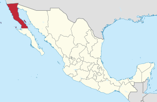
Baja California, officially the Free and Sovereign State of Baja California, is a state in Mexico. It is the northernmost and westernmost of the 32 Federal Entities of Mexico. Before becoming a state in 1952, the area was known as the North Territory of Baja California. It has an area of 70,113 km2 (27,071 sq mi), or 3.57% of the land mass of Mexico and comprises the northern half of the Baja California Peninsula, north of the 28th parallel, plus oceanic Guadalupe Island. The mainland portion of the state is bordered on the west by the Pacific Ocean, on the east by Sonora, the U.S. state of Arizona, and the Gulf of California, and on the south by Baja California Sur. Its northern limit is the U.S. state of California.

Mexicali Place in Baja California, Mexico

Mexicali is the capital city of the Mexican state of Baja California and seat of the Municipality of Mexicali. The City of Mexicali has a population of 689,775, according to the 2010 census, while the population of the entire metropolitan area reaches 996,826; making the city and metropolitan area the second most populous in Baja California.

The Sierra de los Cucapah are north-south trending mountains of the Peninsular Ranges between the Laguna Salada basin to the west and the Cerro Prieto Volcano and Cerro Prieto Geothermal Power Station to the east.

Peninsular Ranges

The Peninsular Ranges are a group of mountain ranges that stretch 1,500 km (930 mi) from Southern California to the southern tip of the Baja California Peninsula; they are part of the North American Coast Ranges, which run along the Pacific Coast from Alaska to Mexico. Elevations range from 500 to 10,834 feet.

Laguna Salada (Mexico) lake in Mexico

Laguna Salada is a vast dry lake some 10 meters below sea level in the Sonoran Desert of Baja California, 30 km (19 mi) southwest of Mexicali. The lake's shape vaguely resembles a rhombus. When dry, the flatness of the exposed lake bed sediments makes it a favoured location for recreational driving. It is also notorious for its dust storms, usually the result of monsoonal thunderstorms during the summer. During times of significant rain the lagoon can fill completely with water, leaving the unpaved road along its west bank as the only means of traversing the area. Flanked by the Sierra de Los Cucapah and the Sierra de Juárez mountain ranges, the lake is approximately 60 km (37 mi) long and 17 km (11 mi) at its widest point.

Cerro Prieto volcano in Mexico

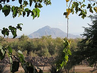
Cerro Prieto is a volcano located approximately 29 km (18 mi) SSE of Mexicali in the Mexican state of Baja California. The volcano lies astride a spreading center associated with the East Pacific Rise. This spreading center is also responsible for a large geothermal field which has been harnessed to generate electric power by the Cerro Prieto Geothermal Power Station.

The geothermal field is 40 kilometres (25 mi) south of Mexicali. [1]

Geothermal power electricity generated from geothermal energy

Geothermal power is power generated by geothermal energy. Technologies in use include dry steam power stations, flash steam power stations and binary cycle power stations. Geothermal electricity generation is currently used in 24 countries, while geothermal heating is in use in 70 countries.

Related Research Articles

Baja California Peninsula peninsula of North America on the Pacific Coast of Mexico

The Baja California Peninsula is a peninsula in Northwestern Mexico. It separates the Pacific Ocean from the Gulf of California. The peninsula extends 1,247 km from Mexicali, Baja California in the north to Cabo San Lucas, Baja California Sur in the south. It ranges from 40 km at its narrowest to 320 km at its widest point and has approximately 3,000 km of coastline and approximately 65 islands. The total area of the Baja California Peninsula is 143,390 km2 (55,360 sq mi).

Sierra de San Pedro Mártir mountain range

Sierra de San Pedro Mártir is a mountain range located within southern Ensenada Municipality and southern Baja California state, of northwestern Mexico.

Sierra Morena mountain range in Spain

The Sierra Morena is one of the main systems of mountain ranges in Spain. It stretches for 450 kilometres from east to west across the south of the Iberian Peninsula, forming the southern border of the Meseta Central plateau and providing the watershed between the valleys of the Guadiana to the north and the west, and the Guadalquivir to the south.

Mexicali Municipality Municipality in Baja California, Mexico

Mexicali Municipality is a municipality in the Mexican state of Baja California. Its municipal seat is located in the city of Mexicali. As of 2010, the municipality had a total population of 936,826, and according to the 2000 census, it had 764,602 inhabitants. The municipality has an area of 13,700 km² This includes many smaller outlying communities as well as the city of Mexicali. Also, the islands of Baja California located in the Gulf of California are part of the municipality, among them the mudflat islands at the mouth of the Colorado River, Isla Ángel de la Guarda and the islands of the San Lorenzo Marine Archipelago National Park. Mexicali is the northernmost municipality of Latin America.

Estadio Nido de los Aguilas, officially known due to sponsorship as Estadio B'Air, is a stadium in Mexicali, Mexico. It is primarily used for baseball and has a capacity of over 17,000 spectators.

Sierra Madre de Oaxaca

The Sierra Madre de Oaxaca is a mountain range in southern Mexico. It is primarily in the state of Oaxaca, and extends north into the states of Puebla and Veracruz.

Federal Highway 5 is a free part of the federal highways corridors, and follows the northeast length of the state of Baja California from the US-Mexico border in Mexicali at the northern point at San Felipe in the south. The highway is entirely inside the Mexicali Municipality. However, a state highway from San Felipe to Puertecitos is usually considered part of Fed. 5. From San Felipe to the south, the road follows the seacoast of the Gulf of California. It has a total length of 400 km. but only 370 km from Mexicali to San Luis Gonzanga are paved. The 30 km beyond San luis Gonzanga to Chapal is to be paved.

The Hardy River is a 26-kilometer (16 mi)-long Mexican river formed by residual agricultural waters from the Mexicali Valley and running into the Colorado River. The river is believed to have been an ancient channel of the Colorado. In the 19th century, a sea captain explored the Colorado River Delta, and noted that the main channel of the Colorado followed this course. Later in the 1880s, sea captains noted that the main channel of the Colorado had moved east, and this old channel became known as Hardy's Colorado.

Cerro Prieto Geothermal Power Station

The Cerro Prieto Geothermal Power Station is the largest complex of geothermal power stations by size not by output, with an installed capacity of 820 MW The facility is located just south of Mexicali, Baja California, in Mexico, and is built in five individual units, namely CP1, CP2, CP3, CP4 and CP5.

2010 Baja California earthquake earthquake

The 2010 Baja California earthquake occurred on April 4 with a moment magnitude of 7.2 and a maximum Mercalli intensity of VII. The shock originated at 15:40:41 local time south of Guadalupe Victoria, Baja California, Mexico.

Brawley Seismic Zone

The Brawley Seismic Zone (BSZ), also known as the Brawley fault zone, is a predominantly extensional tectonic zone that connects the southern terminus of the San Andreas Fault with the Imperial Fault in Southern California. The BSZ is named for the nearby town of Brawley in Imperial County, California, and the seismicity there is characterized by earthquake swarms.

Cerro Prieto Fault

The Cerro Prieto Fault is a transform fault located in far northern Baja California. It runs between the Cerro Prieto spreading center located southwest of Mexicali, and the Wagner Basin, another spreading center which lies under the Gulf of California. These spreading centers are part of the East Pacific Rise, the northern leg of which has formed the Gulf of California by steadily rifting the Baja California Peninsula away from the mainland of Mexico.

Calexico–Mexicali Metropolitan area

Calexico–Mexicali is an international metropolitan area in southeastern California and northwestern Baja California with its center being the border between the sister cities of Calexico and Mexicali. The metropolitan area lies in the south of Salton Valley where the valley is divided into the Imperial Valley and Mexicali Valley.

Distribution of <i>Heliamphora</i>

The natural range of the carnivorous plant genus Heliamphora is restricted to the southern Venezuelan states of Amazonas and Bolívar, and to adjacent portions of northern Brazil and western Guyana, an area corresponding to the western part of the Guayana Shield. These plants are largely confined to the summits and foothills of the sandstone table-top mountains of the region, known as tepuis.

El Centinela (Baja California)

Mount Signal is a mountain 20 km (12 mi) west of Mexicali, Baja California, Mexico, on Mexican Federal Highway 2. The peak is also known as "Weeishpa" by the native community Kumiai or "Cerro del Centinela" or simply: El Centinela by the Mexicans. The northern slope of the mountain begins at the border between Mexico and the United States, the south side is bordered by Federal Highway 2. It has an elevation of about 781 meter and is the northernmost peak of the Cocopah mountain range or sierra cucapá.

The Pachuca Range is a mountain range in the Sierra Madre Oriental of central Mexico, in the state of Hidalgo. The highest point is Cerro de las Navajas at 3212 meters.

Salton Buttes active volcanoes in Southern California

The Salton Buttes are a group of volcanoes in the Niland Field. The buttes are found in California, on the Salton Sea. They consist of a 7 kilometres (4.3 mi)-long row of five lava domes, named Mullet Island, North Red Hill, Obsidian Butte, Rock Hill and South Red Hill. They are closely associated with a fumarolic field and a geothermal field, and there is evidence of buried volcanoes underground. In pre-modern times Obsidian Butte was an important regional source of obsidian.

References

Coordinates: 32°23′59″N115°30′02″W / 32.39968°N 115.50064°W / 32.39968; -115.50064

Geographic coordinate system Coordinate system

A geographic coordinate system is a coordinate system that enables every location on Earth to be specified by a set of numbers, letters or symbols. The coordinates are often chosen such that one of the numbers represents a vertical position and two or three of the numbers represent a horizontal position; alternatively, a geographic position may be expressed in a combined three-dimensional Cartesian vector. A common choice of coordinates is latitude, longitude and elevation. To specify a location on a plane requires a map projection.