
Geothermal energy is thermal energy extracted from the Earth's crust. It combines energy from the formation of the planet and from radioactive decay. Geothermal energy has been exploited as a source of heat and/or electric power for millennia.

Geothermal power is electrical power generated from geothermal energy. Technologies in use include dry steam power stations, flash steam power stations and binary cycle power stations. Geothermal electricity generation is currently used in 26 countries, while geothermal heating is in use in 70 countries.

Energy in Mexico describes energy, fuel, and electricity production, consumption and import in Mexico.

Kenya Electricity Generating Company PLC abbreviated to KenGen, is a government enterprise in the Republic of Kenya charged with the production of electricity for the country. KenGen is the largest electric power producer in Kenya, generating over 60% of the electricity consumed in the country.
The Olkaria II Geothermal Power Station also known as Olkaria II Geothermal Power Plant is a geothermal power plant in Kenya, with installed electric generating capacity of 105 megawatts (141,000 hp)
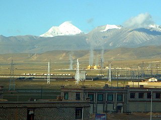
Geothermal exploration began in China in the 1970s. It was initially handled by national bodies with public investments, and productive wells were transferred free of charge to the final user. Since the mid-1990s, under the framework of privatization and liberalization of the economy, national investment in exploration has been reduced. No new plants have been commissioned in the period 2000–2005. The only electricity-producing fields are located in Tibet. According to the "2005 Chinese Geothermal Environment Bulletin" by China's Ministry of Land and Resources, the direct utilization of geothermal energy in China will reach 13.76 cubic metres (486 cu ft) per second, and the geothermal energy will reach 10,769 megawatts, ranking first in the world.

The Riverside Generating Station is a 261 MW electric generating station operated by Exelon that is located at 4000 Broening Highway in Dundalk, Maryland. The station is on Sollers Point on the Patapsco River.
Sierra de Los Cucapah is a mountain range in Baja California state, Northwestern Mexico. It is located south of Mexicali. The range is named after the Cocopah who arrived in the area around 700 b.c and still live in the area.

The Olkaria III Geothermal Power Station, is a large geothermal power plant in Kenya, having an installed electricity generating capacity of 150 megawatts (200,000 hp).
Cerro Prieto is a volcano located approximately 29 km (18 mi) SSE of Mexicali in the Mexican state of Baja California. The volcano lies astride a spreading center associated with the East Pacific Rise. This spreading center is also responsible for a large geothermal field, which has been harnessed to generate electric power by the Cerro Prieto Geothermal Power Station.

Stave Falls Dam is a dual-dam power complex on the Stave River in Stave Falls, British Columbia, Canada. The dam was completed in 1912 for the primary purpose of hydroelectric power production. To increase the capacity of Stave Lake, the dam was raised in 1925 and the Blind Slough Dam constructed in an adjacent watercourse 500 m (1,600 ft) to the north, which was the site of the eponymous Stave Falls. In 2000, the dam's powerhouse was replaced after a four-year upgrade. The original Stave Falls powerhouse was once British Columbia's largest hydroelectric power source, and is a National Historic Site of Canada.
Renewable energy in Chile is classified as Conventional and Non Conventional Renewable Energy (NCRE), and includes biomass, hydro-power, geothermal, wind and solar among other energy sources. Usually, when referring to Renewable Energy in Chile, it will be the Non Conventional kind.
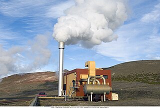
The Bjarnarflag Geothermal Station is the smallest geothermal station operated by Landsvirkjun, the Icelandic national power company. It is located in the north of Iceland near Námafjall Mountain in the geothermal area of Mývatn. It lies just a few kilometres from the Ring road, around 100 km from Akureyri, and approximately 400 km from the capital city of Reykjavík. It was officially launched on 5 March 1969.

The Olkaria V Geothermal Power Station, also known as the Olkaria V Geothermal Power Plant is a power station in Kenya, with an electric capacity of 158 megawatts (212,000 hp).
The Salton Buttes are a group of volcanoes in Southern California, on the Salton Sea. They consist of a 7-kilometer (4.3 mi)-long row of five lava domes, named Mullet Island, North Red Hill, Obsidian Butte, Rock Hill and South Red Hill. They are closely associated with a fumarolic field and a geothermal field, and there is evidence of buried volcanoes underground. In pre-modern times Obsidian Butte was an important regional source of obsidian.
