
Cestica is a village and municipality in Croatia in the Varaždin County. According to the 2001 census, there are 5,678 inhabitants, the majority of whom are Croats.
Nouvelles is a village near the Belgian town of Mons in the province of Hainaut.

Dąb Wielki is a village in the administrative district of Gmina Włocławek, within Włocławek County, Kuyavian-Pomeranian Voivodeship, in north-central Poland. It lies approximately 23 kilometres (14 mi) east of Włocławek and 69 km (43 mi) south-east of Toruń.
Võilaid is a small, uninhabited island in the Baltic Sea belonging to the country of Estonia. Its coordinates are 58°30′56″N23°22′12″E.

Narınclar is a village in the Kalbajar Rayon of Azerbaijan.
Cılfır is a village in the Qubadli Rayon of Azerbaijan. Cılfır is the Azeri village in Qubadli
Ruda Strawczyńska is a village in the administrative district of Gmina Strawczyn, within Kielce County, Świętokrzyskie Voivodeship, in south-central Poland. It lies approximately 4 kilometres (2 mi) west of Strawczyn and 19 km (12 mi) west of the regional capital Kielce.

Zakrzówek is a village in the administrative district of Gmina Kazanów, within Zwoleń County, Masovian Voivodeship, in east-central Poland. It lies approximately 17 kilometres (11 mi) south-west of Zwoleń and 106 km (66 mi) south of Warsaw.
Ignaców is a village in the administrative district of Gmina Przyłęk, within Zwoleń County, Masovian Voivodeship, in east-central Poland.
Zelenyi Bir is a small village in the Kiev Oblast of central Ukraine. It has 794 inhabitants.
Koziegłowy is a village in the administrative district of Gmina Kleczew, within Konin County, Greater Poland Voivodeship, in west-central Poland.
Śliwno is a village in the administrative district of Gmina Kuślin, within Nowy Tomyśl County, Greater Poland Voivodeship, in west-central Poland. It lies approximately 20 kilometres (12 mi) north-east of Nowy Tomyśl and 37 km (23 mi) west of the regional capital Poznań.

Nau, also Nov, is a town and jamoat in Tajikistan located in Sughd Province south-west of Khujand at 40°8′59″N69°22′12″E. It is the administrative capital of Spitamen district with population of 14,300
Windykajmy is a village in the administrative district of Gmina Kętrzyn, within Kętrzyn County, Warmian-Masurian Voivodeship, in northern Poland.

Inovo is a village in the municipality of Knjaževac, Serbia. According to the 2002 census, the village has a population of 100 people.

Markova Sušica is a village in the Studeničani Municipality, near Skopje, North Macedonia. The village is home to Marko's Monastery.

Kovačići is a village in the municipality of Nevesinje, Republika Srpska, Bosnia and Herzegovina.
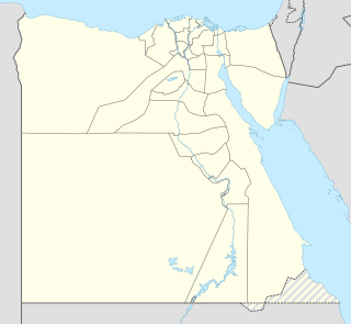
The Monastery of Saint Matthew the Potter, also known as the Monastery of Saint Matthew the Poor, is a Coptic Orthodox monastery in Upper Egypt. It was founded by a Coptic monk of the same name. It is located in Luxor Governorate near the town of Naq 'al-Zinaiqa, about seven kilometers northwest of the village of Asfun al-Matana near Esna. The monastery is built at the edge of the desert. It was uninhabited for a period of time, but in 1975, Coptic Orthodox monks reestablished a presence there. Excavations done by French archeologists between the Monastery of Saint Matthew the Poor and the Monastery of the Martyrs have revealed much about the history of Coptic monasticism in this region.

Clyst Hydon is a village and civil parish in the county of Devon, England. It was in the Cliston Hundred and has a church dedicated to St Andrew. The parish is surrounded, clockwise from the north, by the parishes of Cullompton, Plymtree, Payhembury, Talaton, Whimple, Clyst St Lawrence and Broad Clyst.
Tarasivtsi is a village in Ukraine in the Novoselytsia Raion, Chernivtsi Oblast. The population of the village is more than 5000 people, of which 95% are ethnic Romanians and Moldovans.


