Silesia is a historical region of Central Europe that lies mostly within Poland, with small parts in the Czech Republic and Germany. Its area is approximately 40,000 km2 (15,400 sq mi), and the population is estimated at around 8,000,000. Silesia is split into two main subregions, Lower Silesia in the west and Upper Silesia in the east. Silesia has a diverse culture, including architecture, costumes, cuisine, traditions, and the Silesian language. The largest city of the region is Wrocław.

Upper Silesia is the southeastern part of the historical and geographical region of Silesia, located today mostly in Poland, with small parts in the Czech Republic. The area is predominantly known for its heavy industry.

The Province of Silesia was a province of Prussia from 1815 to 1919. The Silesia region was part of the Prussian realm since 1742 and established as an official province in 1815, then became part of the German Empire in 1871. In 1919, as part of the Free State of Prussia within Weimar Germany, Silesia was divided into the provinces of Upper Silesia and Lower Silesia. Silesia was reunified briefly from 1 April 1938 to 27 January 1941 as a province of Nazi Germany before being divided back into Upper Silesia and Lower Silesia.

Nowa Sól is a city on the Oder River in Lubusz Voivodeship, western Poland. It is the capital of Nowa Sól County and had a population of 38,763 (2019).

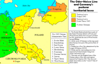
The former eastern territories of Germany refer in present-day Germany to those territories east of the current eastern border of Germany, i.e., the Oder–Neisse line, which historically had been considered German and which were annexed by Poland and the Soviet Union after World War II in Europe. In most of these territories, Germans used to be the dominant or sole ethnicity. In contrast to the lands awarded to the restored Polish state by the Treaty of Versailles after World War I, the German territories lost with the Potsdam Agreement after World War II in Europe on 2 August 1945 were either almost exclusively inhabited by Germans before 1945, mixed German-Polish with a German majority, or mixed German-Czech with a German majority (Glatz). Virtually the entire German population of the territories that did not flee voluntarily in the face of the Red Army advance of 1945, was expelled to Germany, with their possessions being expropriated.

Cieszyn Silesia, Těšín Silesia or Teschen Silesia is a historical region in south-eastern Silesia, centered on the towns of Cieszyn and Český Těšín and bisected by the Olza River. Since 1920 it has been divided between Poland and Czechoslovakia, and later the Czech Republic. It covers an area of about 2,280 square kilometres (880 sq mi) and has about 810,000 inhabitants, of which 1,002 square kilometres (387 sq mi) (44%) is in Poland, while 1,280 square kilometres (494 sq mi) (56%) is in the Czech Republic.

The Province of Upper Silesia was a province of the Free State of Prussia from 1919 to 1945. It comprised much of the region of Upper Silesia and was eventually divided into two government regions called Kattowitz (1939–1945), and Oppeln (1819–1945). The provincial capital was Oppeln (1919–1938) and Kattowitz (1941–1945), while other major towns included Beuthen, Gleiwitz, Hindenburg O.S., Neiße, Ratibor and Auschwitz, added in 1941. Between 1938 and 1941 it was reunited with Lower Silesia as the Province of Silesia.

In the second half of the 2nd millennium B.C., Silesia belonged to the Lusatian culture. About 500 BC Scyths arrived, and later Celts in the South and Southwest. During the 1st century BC Silingi and other Germanic people settled in Silesia. For this period we have written reports of antique authors who included the area. Slavs arrived in this territory around the 6th century. The first known states in Silesia were those of Greater Moravia and Bohemia. In the 10th century, Mieszko I incorporated Silesia into Civitas Schinesghe, a Polish state. It remained part of Poland until the Fragmentation of Poland. Afterwards it was divided between Piast dukes, descendants of Władysław II the Exile, High Duke of Poland.

Czech Silesia is the part of the historical region of Silesia now in the Czech Republic. Czech Silesia is, together with Bohemia and Moravia, one of the three historical Czech lands.

The Duchy of Silesia with its capital at Wrocław was a medieval duchy located in the historic Silesian region of Poland. Soon after it was formed under the Piast dynasty in 1138, it fragmented into various Silesian duchies. In 1327, the remaining Duchy of Wrocław as well as most other duchies ruled by the Silesian Piasts passed to the Kingdom of Bohemia as Duchies of Silesia. The acquisition was completed when King Casimir III the Great of Poland renounced his rights to Silesia in the 1335 Treaty of Trentschin.

Austrian Silesia, officially the Duchy of Upper and Lower Silesia, was an autonomous region of the Kingdom of Bohemia and the Habsburg monarchy. It is largely coterminous with the present-day region of Czech Silesia and was, historically, part of the larger Silesia region.

Głubczyce is a town in Opole Voivodeship in southern Poland, near the border with the Czech Republic. It is the administrative seat of Głubczyce County and Gmina Głubczyce.

Lower Silesia is a historical and geographical region mostly located in Poland with small portions in the Czech Republic and Germany. It is the western part of the region of Silesia.
Silesian as an adjective can mean anything from or related to Silesia. As a noun, it refers to an article, item, or person of or from Silesia.

Stonava is a municipality and village in Karviná District in the Moravian-Silesian Region of the Czech Republic. It has about 1,800 inhabitants. The municipality has a significant Polish minority.

is a municipality and village in Frýdek-Místek District in the Moravian-Silesian Region of the Czech Republic. It has about 1,700 inhabitants. The municipality has a significant Polish minority.

is a village in Karviná District, Moravian-Silesian Region, Czech Republic. It was a separate municipality but became administratively a part of Petrovice u Karviné in 1952. Petrůvka River flows through the village.
East Upper Silesia is the easternmost extremity of Silesia, the eastern part of the Upper Silesian region around the city of Katowice. The term is used primarily to denote those areas that became part of the Second Polish Republic on 20 June 1922, as a consequence of the post-World War I Treaty of Versailles. Prior to World War II, the Second Polish Republic administered the area as Autonomous Silesian Voivodeship. East Upper Silesia was also known as Polish (Upper) Silesia, and the German (Upper) Silesia was known as West Upper Silesia.

The coat of arms of Lower Silesia, and simultaneously of Silesia, shows a black eagle with silver crescent with cross in the middle on its chest on a golden background. It has been assumed in the tradition that the coat of arms and colors of Lower Silesia are simultaneously used as symbols of Silesia as a whole.

The flag that serves as the symbol of the historical and geographical regions of the Silesia, and Lower Silesia, and as one of the symbols of the Silesian people, is divided horizontally into two stripes: white on the top and yellow on the bottom. It originated as the flag of the Province of Silesia, used from 1882 to 1919, that later used as the flag of the Province of Lower Silesia, from 1920 to 1935. Currently, the flag is recognized symbol of the Silesian people in the state of Saxony in Germany.


