Related Research Articles
Simpson most often refers to:

This is a list of the extreme points of North America: the points that are highest and lowest, and farther north, south, east or west than any other location on the continent. Some of these points are debatable, given the varying definitions of North America.

The Liard River of the North American boreal forest flows through Yukon, British Columbia and the Northwest Territories, Canada. Rising in the Saint Cyr Range of the Pelly Mountains in southeastern Yukon, it flows 1,115 km (693 mi) southeast through British Columbia, marking the northern end of the Rocky Mountains and then curving northeast back into Yukon and Northwest Territories, draining into the Mackenzie River at Fort Simpson, Northwest Territories. The river drains approximately 277,100 km2 (107,000 sq mi) of boreal forest and muskeg.

The Dease River flows through northwestern British Columbia, Canada and is a tributary of the Liard River. The river descends from Dease Lake, though its ultimate origin is in the headwaters of Little Dease Creek at Snow Peak, approximately 50 kilometres (31 mi) west of the lake. The river flows 265 kilometres (165 mi) generally north-eastward, draining into the Liard River near Lower Post, British Columbia. Large sections of the river parallel the Cassiar Highway, helping to make it a popular destination for canoeists, kayakers, and rafters.
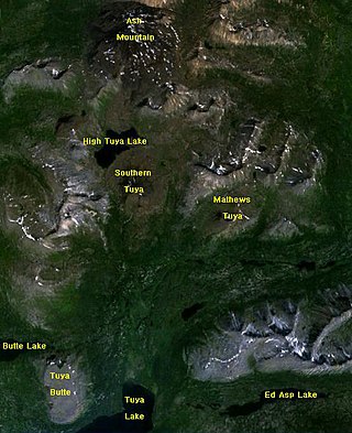
The Tuya volcanic field is a volcanic field of tuyas located in far northern British Columbia, Canada, near the border with the Yukon Territory and focused on the area of the Tuya Range, a subrange of the Stikine Ranges of the Cassiar Mountains, though some vents are in the Kawdy Plateau, the northernmost part of the Stikine Plateau. Several small shield volcanoes, and postglacial lapilli cones and lava flows have been reported in this area. The only nonglacial volcanoes in the field are Gabrielse Cone and the West Tuya lava field.
The Skeena Mountains, also known as the Skeenas, are a subrange of the Interior Mountains of northern British Columbia, Canada, essentially flanking the upper basin of the Skeena River. They lie just inland from the southern end of the Boundary Ranges of the Coast Mountains, and also of the northern end of the Kitimat Ranges. Their southern limit is described by the Bulkley River and the upper northwestern reaches of Babine and Takla Lakes, and on their northeast by the upper reaches of the Omineca River.

The Cassiar Mountains are the most northerly group of the Northern Interior Mountains in the Canadian province of British Columbia and also extend slightly into the southernmost Yukon Territory. They lie north and west of the Omineca Mountains, west of the northernmost Rockies and the Rocky Mountain Trench, north of the Hazelton Mountains and east of the Boundary Ranges. They form a section of the Continental Divide, that, in this region, separates water drainage between the Arctic and Pacific Oceans. Physiographically, they are a section of the larger Yukon-Tanana Uplands province, which in turn are part of the larger Intermontane Plateaus physiographic division.
The Stikine Ranges are a group of mountain ranges and mountainous plateaus in northwestern British Columbia, Canada. They are the northernmost subdivision of the Cassiar Mountains and among the least explored and most undeveloped parts of the province.
The Tuya Range is a mountain range in the Stikine Ranges of the Cassiar Mountains in the far north of the Canadian province of British Columbia, near its border with the Yukon Territory and to the southwest of Watson Lake, Yukon, which is the nearest major settlement.
Toozaza Peak is a tuya in the Stikine Ranges of the Cassiar Mountains in northern British Columbia, Canada, located in the Iverson Creek. Toozaza Peak is the summit of a north–south aligned ridge between the head of Toozaza Creek and the head of the Jennings River, just south of the Jennings' divide with the Little Rancheria River headwaters. The Little Rancheria and Toozaza Creek are part of the Liard, while the Jennings is part of the Yukon River drainage via Teslin Lake, and the peak therefore stands astride the line of the Continental Divide. It is part of the Tuya Volcanic Field, a volcanic field associated with the Stikine Volcanic Belt, part of the Northern Cordilleran Volcanic Province.

Esther Mountain is a mountain located in Essex County, New York. The mountain is the northernmost of the High Peaks of the Adirondack Mountains and its 28th highest peak. It was the only High Peak named for a woman until 2014, having been named in honor of Esther McComb, who made the first recorded climb to the summit in 1839, at age 15; at the time she was attempting to climb Whiteface Mountain from the north.
The Pemberton Icefield or Pemberton Icecap, is the southernmost of the series of very large icefields studding the Pacific Ranges of the southern Coast Mountains in British Columbia, Canada.

The Stikine Plateau is a plateau in northern British Columbia, Canada. It lies between the Boundary Ranges of the Coast Mountains on the west and southwest and the Cassiar Mountains along its northeast, and between the Skeena Mountains on its south and southeast and the Jennings and Nakina Rivers on the north.
The Swift River is a river that begins in Yukon Territory and flows southwest into British Columbia to its mouth at the east side of Teslin Lake on the Teslin River system. The river drains the uppermost portion of the Cassiar Mountains and in its lower reaches traverses the Nisutlin Plateau, which lies along the east side of Teslin Lake north of the mouth of the Jennings River, which is to the south of the Swift.
The Rancheria River is a tributary of the Liard River in the southern Yukon Territory, Canada, just north of the border with British Columbia. The river's main tributary is the Little Rancheria River, which begins in British Columbia. Both river basins are in the northernmost of extension of the Stikine Ranges of the Cassiar Mountains, which extend from the Finlay River north to the Liard and end just inside the Yukon, with the Rancheria River forming the northern end of the range.
The Jennings River is a river in far northern British Columbia, Canada. It is approximately 150 kilometres (93 mi) long. The river was named for William T. Jennings (1846-1906), a civil engineer who, in 1897, assessed various road and railroad routes from the Pacific Ocean to the Yukon.
The Cottonwood River is a tributary of the Dease River in the Cassiar Country of the Northern Interior of British Columbia, Canada. Rising in the northern Stikine Ranges just east of Toozaza Peak, and just south of the origins of the Jennings and Little Rancheria River near the border with Yukon, it flows south along the east flank of the Tuya Range to meet the Dease just north of that river's source at Dease Lake, between the north end of that lake and McDame Creek and the former mining centre and community of McDame Post.
The Red River is a tributary of the Kechika River in the far north of British Columbia, Canada, flowing east to meet the Kechika from headwaters in the Cassiar Mountains. In its middle reaches it forms the boundary between the Dease Plateau (N) and the Cassiar Mountains (S) and for its final stretch it crosses part of the Liard Plain. It is crossed by an unnamed road about 17.5 kilometres (10.9 mi) upstream from its confluence with the Kechika, and is just to the north of Aeroplane Lake.
The Cassiar Land District is a cadastral survey subdivision of the province of British Columbia, Canada, created with rest of those on Mainland British Columbia via the Lands Act of the Colony of British Columbia in 1860. The British Columbia government's BC Names system, a subdivision of GeoBC, defines a land district as "a territorial division with legally defined boundaries for administrative purposes". All land titles and surveys use the Land District system as the primary point of reference, and entries in BC Names for placenames and geographical objects are so listed.
References
59°43′24″N131°26′53″W / 59.72333°N 131.44806°W
| | This article related to a mountain in British Columbia, Canada is a stub. You can help Wikipedia by expanding it. |
| | This article about a location in the Interior of British Columbia, Canada is a stub. You can help Wikipedia by expanding it. |