The Iron Age is the final epoch of the three historical Metal Ages, after the Chalcolithic and Bronze Age. It has also been considered as the final age of the three-age division starting with prehistory and progressing to protohistory. In this usage, it is preceded by the Stone Age and Bronze Age. These concepts originated for describing Iron Age Europe and the Ancient Near East. In the Archaeology of the Americas, a five-period system is conventionally used instead; indigenous cultures there did not develop an iron smelting economy in the Pre-Columbian era, though some did work copper, bronze, unsmelted iron, and iron from East Asian shipwrecks. Indigenous metalworking arrived in Australia with European contact.
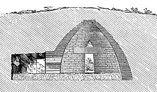
A beehive tomb, also known as a tholos tomb, is a burial structure characterized by its false dome created by corbelling, the superposition of successively smaller rings of mudbricks or, more often, stones. The resulting structure resembles a beehive, hence the traditional English name.

A kurgan is a type of tumulus constructed over a grave, often characterized by containing a single human body along with grave vessels, weapons, and horses. Originally in use on the Pontic–Caspian steppe, kurgans spread into much of Central Asia and Eastern, Southeast, Western, and Northern Europe during the third millennium BC.

The flag of Oman consists of a horizontal tricolor of white, red and green with a vertical red stripe on the left that contains the national emblem of Oman.

Ash-Sharqiyyah Region was the eastern minṭaqah (region) of the Sultanate of Oman. The capital of Ash-Sharqiyyah is Sur. On 28 October 2011 Ash Sharqiyah Region was split into Ash Sharqiyah North Governorate and Ash Sharqiyah South Governorate.

Muttrah, administratively a wilayah (province), is located in the Muscat Governorate of Oman. Before the discovery of oil in Oman, Muttrah was the center of commerce in Oman (Muscat). It is still a center of commerce as one of the largest seaports of the region is located there. Other landmarks include Souq Muttrah, a traditional bazaar and Sour Al-Lawatiah, a small community of houses surrounded by an old wall. To the south lies Muscat District.
Ibri is a city and Wilāyat (Province) in the Ad Dhahirah Governorate, in northwest Oman.
Izki is a town in the Ad Dakhiliyah region of northeastern Oman. It is located at c. 544 m (1,785 ft) altitude, and has a population of 35,173 (2003 census).

Alacahöyük or Alaca Höyük is the site of a Neolithic and Hittite settlement and is an important archaeological site. It is situated near the village of Alacahüyük in the Alaca District of Çorum Province, Turkey, northeast of Boğazkale, where the ancient capital city Hattusa of the Hittite Empire was situated. Its Hittite name is unknown: connections with Arinna, Tawiniya, and Zippalanda have all been suggested.

The present-day Sultanate of Oman lies in the south-eastern Arabian Peninsula. There are different definitions for Oman: traditional Oman includes the present-day United Arab Emirates (U.A.E.), though its prehistoric remains differ in some respects from the more specifically defined Oman proper, which corresponds roughly with the present-day central provinces of the Sultanate. In the north, the Oman Peninsula is more specific, and juts into the Strait of Hormuz. The archaeology of southern Oman Dhofar develops separately from that of central and northern Oman.
Umm Al Nar is a Bronze Age culture that existed around 2600-2000 BCE in the area of the modern-day United Arab Emirates and Northern Oman. The etymology derives from the island of the same name which lies adjacent to the city of Abu Dhabi, the capital of the UAE, which provided early evidence and finds that came to define the period.

The Archaeological Museum of Dion is a museum in Dion in the Pieria regional unit of Central Macedonia, Greece.
Al-Mudhaibi is the largest willaya in Ash Sharqiyah region of Oman. It has two niabas: Sinaw and Samad Ash Shan. Suq Sinaw is one of the most popular suqs in Oman. Dresses, khanjars and jewelry are sold there. It includes villages like Al Sudairah, Barzman, and Al Zahib.
The Tomb of Seuthes III is located near Kazanlak, Bulgaria. Seuthes III was the King of the Odrysian Kingdom of Thrace from c. 331 to c. 300 BC and founder of the nearby Thracian city of Seuthopolis.

The Royal Cemetery at Ur is an archaeological site in modern-day Dhi Qar Governorate in southern Iraq. The initial excavations at Ur took place between 1922 and 1934 under the direction of Leonard Woolley in association with the British Museum and the University of Pennsylvania Museum of Archaeology and Anthropology in Philadelphia, Pennsylvania, United States.
The Archaeological Museum of Chora is a museum in Chora, Messenia, in southern Greece, whose collections focus on the Mycenaean civilization, particularly from the excavations at the Palace of Nestor and other regions of Messenia. The museum was founded in 1969 by the Greek Archaeological Service under the auspices of the Ephorate of Antiquities of Olympia. At the time, the latter included in its jurisdiction the larger part of Messenia.

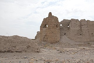
ʿUqdat al-Bakrah, also known incorrectly as Al-Saffah, is an archaeological site in Wadi Ḍank, in the Ad Dhahirah Governorate of northwestern Oman. It is a metal-working site dating to the Early Iron Age.
Archaeology of the United Arab Emirates, the area currently is known as the United Arab Emirates (UAE) was formerly populated by inhabitants of a number of coastal and inland settlements, with human remains pointing to a pattern of transmigration and settlement as far back as 125,000 years. Prehistoric settlement in the UAE spanned the Neolithic, with a number of distinctive eras of ancient settlement including the Stone Age Arabian Bifacial and Ubaid cultures from 5,000 to 3,100 BCE; the Hafit period with its distinctive beehive shaped tombs and Jemdet Nasr pottery, from 3,200 to 2,600 BCE; the Umm Al Nar period from 2,600 to 2,000 BCE; the Wadi Suq culture from 2,000 to 1,300 BCE and the three Iron Ages of the UAE.

Mezyad is a settlement in the Eastern Region of the Emirate of Abu Dhabi, to the south of the main part of Al Ain City, on the border of the U.A.E. and Oman. It is known for having a historical fort, and is part of a desert park, which also includes a necropolis and Mount Hafeet nearby. The park can be called either "Mezyad Desert Park" or "Jebel Hafeet Desert Park".

The Vakhsh culture is a Bronze Age culture which took place around 2500-1650 BC, as shown by radiocarbon dates, and flourished along the lower Vakhsh River in southern Tajikistan, earlier thought to be from ca. 1700 BC to 1500 BC.
Team, FictionX (March 6, 2018). Media Portal - Ministry of Information - Sultanate of Oman. Media Portal - Ministry of Information - Sultanate of Oman. View it on 2023-01-12.

