Singaita River

Last updated

Coordinates: 4°46′22″N33°35′03″E / 4.772644°N 33.584132°E / 4.772644; 33.584132 The Singaita River (also Khawr Thingaita, Khor Thingaita, Rigl Thimgaita, Singeitta) is a river in Eastern Equatoria state of South Sudan that flows through the town of Kapoeta.

Geographic coordinate system Coordinate system

A geographic coordinate system is a coordinate system that enables every location on Earth to be specified by a set of numbers, letters or symbols. The coordinates are often chosen such that one of the numbers represents a vertical position and two or three of the numbers represent a horizontal position; alternatively, a geographic position may be expressed in a combined three-dimensional Cartesian vector. A common choice of coordinates is latitude, longitude and elevation. To specify a location on a plane requires a map projection.

Eastern Equatoria state of South Sudan

Eastern Equatoria is one of the ten states of South Sudan. It has an area of 73,472 km². The capital is Torit.

South Sudan country in Africa

South Sudan, officially known as the Republic of South Sudan, is a landlocked country in East-Central Africa. The country gained its independence from the Republic of the Sudan in 2011, making it the newest country with widespread recognition. Its capital and largest city is Juba.

The Nathilani River, which starts from Nathilan hills in Loudo and flows through Loudo, is one of the Singaita's tributaries. The Murle people at one time lived in the Thingaita Valley, but were later displaced by the Toposa. [1] The Toposa people now live along both sides of the Singaita and Lokalyen rivers. [2]

The Murle are a Nilotic ethnic group inhabiting the Pibor County and Boma area in Jonglei State, South Sudan, as well as parts of southwestern Ethiopia. They have also been referred as Beir by the Dinka and as Jebe by the Luo and Nuer, among others. The Murle speak the Murle language, which is part of the Surmic branch of the Nilo-Saharan family. The language cluster includes some adjoining groups in Sudan, as well as some non-contiguous Nilotic populations in southwestern Ethiopia.

Toposa people ethnic group

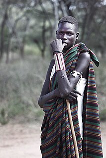
The Toposa are an ethnic group in South Sudan, living in the Greater Kapoeta region of the erstwhile Eastern Equatoria state. They have traditionally lived by herding cattle, sheep and goats, and in the past were involved in the ivory trade. They have a tradition of constant low-level warfare, usually cattle raids, against their neighbors.

The post at Kapoeta on the east bank of the river was established by Captain Knollys, who reached the river in January 1927. [3] Near Kapoeta the river is about 150 yards wide, and normally has a sandy dry bed, but heavy rainstorms in the Didinga Hills can turn it into a raging, impassable flood overnight. [4] A 125-meter drift was built to cross the Thingaita River at Kapoeta with USAID funding in 1983. [5]

Didinga Hills mountain in South Sudan

The Didinga Hills are an upland area in Namorunyang State of South Sudan, lying mainly within Budi County. Before the reorganisation of states, it was an part of Eastern Equatoria. They are named for the Didinga people who live in the region. The Didinga Hills have rich and fertile soil that is used for cultivation of tobacco, potatoes, maize, and Dura.

Related Research Articles

The Didinga (diDinga) occupy the Didinga Mountains region in Budi County, Eastern Equatoria State in South Sudan. They live in the valleys, on the plateaus and slopes, and on the adjacent plains of the region. Their neighbors include the Toposa, the Boya, Ketebo, Logir, Teuth and Dongotona peoples - groups with whom the Didinga have had frequent conflicts due to economic pressures.

Kapoeta Town in Namorunyang State, South Sudan

Kapoeta is a town in South Sudan. It is located in Kapoeta South County, in Namorunyang State, in southeastern South Sudan.

The Boya are an ethnic group numbering 20,000 to 25,000 people living in Budi County, part of the Greater Kapoeta region of the South Sudanese state of the erstwhile Eastern Equatoria.

Budi County in Namorunyang State, South Sudan

Budi County is an administrative area of Namorunyang State. Before the reorganisation of states in 2015, it was a part of Eastern Equatoria state in South Sudan, with headquarters in Chukudum.

Peter Lorot is a former officer who served with the Sudan People's Liberation Army (SPLA) during the Second Sudanese Civil War (1983-2005). He broke away from the SPLA in 1999 with a Didinga force based on Chukudum, in Budi County of Eastern Equatoria State in South Sudan. In the resulting conflict many people were displaced. As of April 2011 Lorot's forces were still not reconciled with the de facto SPLM government.

Greater Kapoeta

Greater Kapoeta is the name given to the eastern half of the erstwhile Eastern Equatoria State in South Sudan, at one time an administrative region with headquarters in the town of Kapoeta. Greater Kapoeta was divided between Kapoeta County and Budi County, named after the Buya and Didinga (BU-DI) people. Kapoeta County was later split into Kapoeta North, South and East counties.

Namorunyang village in Namorunyang State, South Sudan

Namorunyang is a village and Payam of Kapoeta South County in Namorunyang State, South Sudan.

Kapoeta South County in Namorunyang State, South Sudan

Kapoeta South County is an administrative region in Namorunyang State. Before reorganisation of states in 2015, it was a part of Eastern Equatoria state of South Sudan, with headquarters in Kapoeta town. The county logo is a ram with horns and slightly bent tail. The county includes the Kapoeta Town, Machi and Namorunyang Payams.

Narus, South Sudan Town in Kapoeta, South Sudan

Narus is a community in the Namorunyang State state of South Sudan. It is the headquarters of Kapoeta East County.

The Narus River originates in the east of the Didinga Hills in the erstwhile Eastern Equatoria State, South Sudan. It flows eastward and discharges into the swampy area northeast of Narus. The river floods during the rainy season, but ceases to flow at other times. Gold has reportedly been panned in the river bed, probably washed down from the Didinga Hills. During the rainy season, the river virtually cuts the town of Narus in two as the riverbed fills and sometimes floods. The small market area is also cut into two halves, one on each side of the riverbed.

Nadapal Place in Kapoeta East County, South Sudan

Nadapal is a community in the south west of Kapoeta East County, South Sudan near the border with the Rift Valley province of Kenya. The Nadapal belt is an area stretching 25 kilometres (16 mi) southward from the border with South Sudan to Lokichogio in Kenya.

The Loyuro River is a stream in Eastern Equatoria State of South Sudan. The river originates in the east of Didinga Hills, flowing eastward into Greater Kapoeta and discharging into the swampy area northeast of Narus. The river floods during the rainy season, but ceases to flow at other times. The Toposa people have a ritual center at Loyuro River. Lolimi is a permanent water hole on the river, on the road between Narus and Kapoeta.

Riwoto in Eastern Equatoria, South Sudan

Riwoto is a community in Eastern Equatoria state of South Sudan. It is a payam and village in Kapoeta North County.

Natinga is a refugee camp and a school that was established in 1993 in South Sudan for boys forced from their homes by the Second Sudanese Civil War. It is the center of a payam in Kapoeta East County of Eastern Equatoria.

Kapoeta East County County in Namorunyang State, South Sudan

Kapoeta East County is an administrative region of Namorunyang State. Before reorganisation of states in 2015, it was a part of Eastern Equatoria state in South Sudan, bordered by Kenya to the south, Ethiopia to the east and Jonglei state to the west. It is part of the Greater Kapoeta region of the state. The largest ethnic group is the Toposa people. The principal town is Narus. The county includes the disputed Ilemi triangle, controlled by Kenya. The emblem of the county is a horned bull, with big humps and a large tail.

Nanyangachor Village in Eastern Equatoria, South Sudan

Nanyangachor is a community in Eastern Equatoria state of South Sudan. It is in the Eastern Uplands of Kapoeta East County, near the border with Ethiopia.

Kapoeta North County County in Namorunyang State, South Sudan

Kapoeta North County is an administrative division of Namorunyang State. Before reorganisation of states in 2015, it was part of Eastern Equatoria state in South Sudan. The principal settlement is Riwoto and the largest ethnic group are the Toposa people. The county emblem is an elephant.

References

  1. Paul Makenzi (December 2005). "Natural Resource Management in the Didinga Hills - A Baseline Study from Budi County, South Sudan" (PDF). Drylands Conservation Group. Retrieved 2011-07-24.
  2. "SUDAN COUNTRY REPORT" (PDF). IMMIGRATION AND NATIONALITY DIRECTORATE HOME OFFICE, UNITED KINGDOM. October 2004. Retrieved 2011-07-24.
  3. Northeast African Studies, Volume 3. African Studies Center, Michigan State University. 1981. p. 84.
  4. Philosophical Society of the Sudan (1956). Sudan notes and records, Volumes 37-40. p. 13.
  5. "Southern Road Maintenance and Rehab" (PDF). USAID. 1983-07-31. Retrieved 2011-07-24.